Thormanby
Thormanby is a village and civil parish in Hambleton District of North Yorkshire, England. It lies on the A19 approximately halfway between Easingwold and Thirsk and about 14 miles (23 km) south east of the county town of Northallerton.
| Thormanby | |
|---|---|
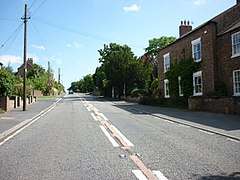
 A19 at Thormanby | |
 Thormanby Location within North Yorkshire | |
| Population | 138 (2011 census)[1] |
| OS grid reference | SE492749 |
| • London | 193 mi (311 km) south |
| District | |
| Shire county | |
| Region | |
| Country | England |
| Sovereign state | United Kingdom |
| Post town | York |
| Postcode district | YO61 |
| Police | North Yorkshire |
| Fire | North Yorkshire |
| Ambulance | Yorkshire |
| UK Parliament | |


History
Thormanby is derived from the Old Norse personal name of Thormothr / Þórmóðr (Tormod in modern Norwegian) and the suffix bi meaning "Thormothr's farm". The name Thormothr means "Thor's gift" (i.e. "mind" and "courage").[2][3][4]
The village is mentioned twice in the Domesday Book of 1086 as "Tormozbi" in the Yarlestre Hundred. Before the Norman Conquest most of the land in the parish belonged to the manor of Earl Morcar, with a small areas owned by Arkil and Gamel. Following Domesday the manor passed to the Crown and, along with the smaller areas of land, was granted to Robert Malet.[2][5] It eventually passed into the Nevill family, lords of the manors of Sheriff Hutton and Raskelf, who held it until the 15th century. It passed through several other families during the next 250 years until it came down to the Dawnay family in 1721. From that date it followed the descent of the manor of Sessay.[6][7] Most of the land in the village was owned by the Viscounts Downe of Wykeham, but much of this was sold in 1918 with the disposing of the Sessay Estate.[2]
William Page in his A History of the County of York North Riding states: "According to tradition there was once a castle here. It is also said that in the rebellion of the Earl of Northumberland in 1569, the royal forces encamped on Thormanby Carr on their way to Maiden Bower near Topcliffe."[8]
In 1870–72, John Marius Wilson's Imperial Gazetteer of England and Wales described Thormanby as:
a parish in Easingwold district, N. R. Yorkshire; 1¾ mile SW of Husthwaite Gate railway station, and 4¼ NNW of Easingwold. It has a post-office under Easingwold. Acres, 958. Real property, £1,042. Pop., 147. Houses, 24. The living is a rectory in the diocese of York. Value, £216.* Patron, alternately Viscount Downe and Sir G. Cayley, Bart. The church is good. Charities, £6.[9]
There were three inns throughout the 17th century and 18th century, but only the Black Bull Inn public house remained until recent years. In 1999 the landlord of the Black Bull, Robert Medd, intended to close the pub, saying "the pub is sometimes more like a morgue," and "sells just 16 pints a day." Residents opposed his application to convert the pub through a belief that the village needed a "focal point".[10]
Governance
The village lies within the Thirsk and Malton UK Parliament constituency. It is also within the Easingwold electoral division of North Yorkshire County Council and the Helperby ward of Hambleton District Council.[11]
Geography
The parish contains 1,002 acres (4.1 km2), of which 454 are arable land and 383 grass.[8] The nearest settlements are the hamlet of Birdforth 0.7 miles (1.1 km) to the north and the villages of Carlton Husthwaite, Hutton Sessay and Husthwaite, which are all within a radius of 1.6 miles (2.6 km). The village lies at and elevation between 148 feet (45 m) and 180 feet (55 m) and is the highest point within the parish. The nearest major city is York, 16 miles (26 km) to the south-east.[11] The Thirsk and Malton branch of the North Eastern Railway passes through the parish, but there is no station here.
Topography
The surface elevation is relatively consistent, varying in height from only 103 feet (31.4 m) to 175 feet (53.3 m) above the Ordnance Survey data. In the south there is an area of low-lying carr (landform) – Sun Beck, Birdforth Beck and Ings Beck, which are part of the tributary system of the River Swale, drain the land and separate Thormanby from Sessay, Birdforth and Carlton Husthwaite respectively.[11][8]
Demography
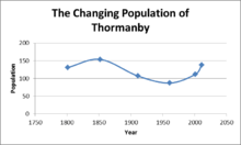
The first United Kingdom Census in 1801 recorded the population as 131. The highest recorded population in UK census returns was in 1852 when there were 154 people. By the time of the 1961 UK census, the population had fallen to 87.[12] The 2001 UK census recorded the population as 112 of which 52.7% were male and 47.3% were female. Of those, 88.4% stated their religion as Christian, with the rest not stating a religion. The ethnicity of the parish was virtually 100% white British. There were 44 dwellings in the Parish. The 2011 UK census recorded the population as 138, an increase of 39.4% on the previous figures, of which 51.4% were male and 48.6% were female. Of those, 70.3% stated their religion as Christian, with the rest not stating a religion. The ethnicity of the Parish was virtually 100% white British.[13]
Occupation history
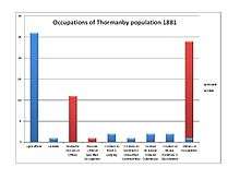
The stacked column chart represents a simplified version of the 1881 occupational data, using the 24 'Orders' used in the published reports for 1881, plus an 'Unknown' category. Many of these categories combine 'Workers and Dealers' in different commodities, so it is impossible to distinguish workers in manufacturing and services. The graph shows that women had no significant occupation apart from domestic service, showing at approximately 31.5% of females. The most common occupation for males in the parish was agriculture, with approximately 74.2% of males being employed in this sector.[14]
Landmarks

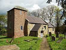
The village church is dedicated to St Mary Magdalene and is a Grade II* listed building.[15] It was built in the 12th century and has been subject to frequent changes up to 1955. The church stands a short distance east of the village on Church Lane. The village rectory is just south-west from the church. The Old Rectory is a Grade II Listed 18th-century Georgian residence, built in 1737 with a later addition of a schoolroom in 1786, and further alterations in 1837.[16] It is now a bed and breakfast.
Near the Rectory is a small redundant Wesleyan chapel, built in 1875, which has now been converted into a private house.[6][7] West of the village, on Birdforth Beck, is Thormanby Mill. A red-brick 19th-century barn at Thormanby Mill is Grade II listed.[17] At the north of the village, on the A19 near Birdforth Bridge, stands a Grade II-listed late 19th-century triangular cast iron mile post.[18]
Notable people
Thomas Whytehead (1815–1843), was a Thormanby-born missionary and poet. He was the fourth son of Henry Robert Whytehead, curate of Thormanby.[19]
Harry Pasley Higginson (1838-1900) was born in Thormanby. He was the son of Revd John (1811–1895) and Mary Maria Hester Higginson (1815–1893). Higginson, who trained in Manchester, was involved in the discovery of dodo bones on Mauritius in 1865.[20] He eventually settled in New Zealand where he became a prominent railway engineer and is commemorated in stained glass at the Wellington Cathedral of St. Paul, Wellington, New Zealand.
References
- UK Census (2011). "Local Area Report – Thormanby Parish (1170216942)". Nomis. Office for National Statistics. Retrieved 13 June 2018.
- "Thormanby Village Information". Visit Easinglwold. 2007. Retrieved 10 April 2013.
- Watts, Victor, ed. (2011). Cambridge Dictionary of English Place-names. Cambridge University Press. p. 609. ISBN 978-0521168557.
- Mills, A.D. (1998). Dictionary of English Place-Names. Oxford Paperbacks. p. 458. ISBN 978-0192800749.
- Thormanby in the Domesday Book. Retrieved 15 February 2013.
- "Parish History". Retrieved 15 February 2013.
- Bulmer's Topography, History and Directory (Private and Commercial) of North Yorkshire 1890. S&N Publishing. 1890. pp. 831–832. ISBN 1-86150-299-0.
- Page, William, ed. (1923). "Parishes: Thormanby". A History of the County of York North Riding: Volume 2. Institute of Historical Research. Retrieved 10 April 2013.
- "Excerpt from Wilson's Imperial Gazetteer 1870–72". GB Historical GIS. University of Portsmouth. Retrieved 7 April 2013.
- Daily Mail (14 July 1999). "UK Crunch time for peace". BBC News. Retrieved 10 April 2013.
- Ordnance Survey Open Viewer
- "Historical census records". Retrieved 15 February 2013.
- "2001 UK Census". Neighbourhood Statistics. Office for National Statistics. Retrieved 29 December 2012.
- "Thormanby CP/AP through time, Industry Statistics and Occupation data classified into the 24 1881 Orders plus sex". A Vision of Britain through Time: GB Historical GIS. University of Portsmouth.
- Historic England. "Church of St Mary Magdalene, Thormanby (1191364)". National Heritage List for England. Retrieved 11 April 2013.
- Historic England. "The Old Rectory, Thormanby (1257990)". National Heritage List for England. Retrieved 11 April 2013.
- Historic England. "Barn at Thormanby Mill, Thormanby (1315212)". National Heritage List for England. Retrieved 11 April 2013.
- Historic England. "Mile Post on Birdforth Bridge, Thormanby (1191361)". National Heritage List for England. Retrieved 11 April 2013.
- Edward Irving Carlyle (1901). Dictionary of National Biography, 1885–1900, Volume 61. Oxford Press. pp. 172–172.
- Hume, J.P.; Cheke, A.S.; McOran-Campbell, A. (2009). "How Owen 'stole' the Dodo: academic rivalry and disputed rights to a newly-discovered subfossil deposit in nineteenth century Mauritius". Historical Biology. 21 (1–2): 33–49. doi:10.1080/08912960903101868.
External links
![]()