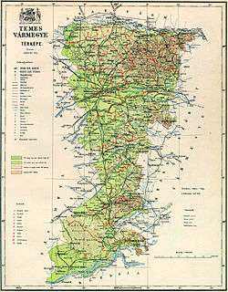
Temes County
County of Temes (Hungarian: Temes, Romanian: Timiș, Serbian: Тамиш or Tamiš, German: Temes or Temesch) was an administrative county (comitatus) of the Kingdom of Hungary, Austria-Hungary. Its territory is now in southwestern Romania and northeastern Serbia. The capital of the county was Temesvár (Romanian: Timișoara, Serbian: Темишвар or Temišvar, German: Temeswar or Temeschwar), which also served as the kingdom's capital between 1315–1323.
| Temes County | |
|---|---|
| County of the Kingdom of Hungary (11th century-1552, 1778-1920) | |
 Coat of arms
| |
 | |
| Capital | Temesvár |
| Area | |
| • Coordinates | 45°45′N 21°14′E |
• 1910 | 7,433 km2 (2,870 sq mi) |
| Population | |
• 1910 | 500835 |
| History | |
• Established | 11th century |
• Ottoman conquest | 26 July 1552 |
• County recreated | June 1778 |
• Treaty of Trianon | 4 June 1920 |
| Today part of | (5,552 km2) (1,881 km2) |
| Timișoara is the current name of the capital. | |
Geography
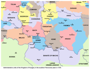
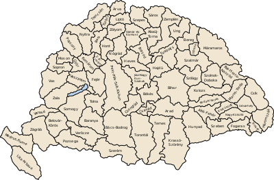
Temes county was located in the Banat region. It shared borders with the Kingdom of Serbia and the Hungarian counties of Torontál, Arad and Krassó-Szörény. The river Danube formed its southern border, and the river Maros its northern border. The river Temes flowed through the county. Its area in 1910 was 7,433 km².
History
Temes County was formed in the 11th century, after the establishment of Hungarian rule in the region. It was named after the local Temes river. Principal center of the County was named Temesvár in Hungarian language, meaning literally: Temes Castle. The area was taken by the Ottoman Empire in 1552 century and the county was abolished. This territory was then included into the Ottoman Temeşvar Eyalet.
After the region was captured by the Habsburgs in 1716, the area was included into the so-called Banat of Temeswar, a Habsburg province with administrative center in Temeswar. This province was abolished in 1778 and the county of Temes was restored. It was incorporated into Habsburg Kingdom of Hungary.
Between 1849 and 1860, the area of the county was part of Voivodeship of Serbia and Temes Banat, a separate Austrian crown land. During this time, the county did not exist since voivodeship was divided into districts. Temes County was re-established after 1860, when the area was again incorporated into the Habsburg Kingdom of Hungary.
In 1918, the county first became part of the newly proclaimed Banat Republic that lasted only few days. The region was taken by Serbian and French troops, and then divided in 1919 between Romania and the also newly formed Kingdom of Serbs, Croats and Slovenes, as both of the powers claimed the entire territory of the Banat. The border arrangements were set by the Paris Peace Conference. A majority of the county was assigned to Romania, while the south-western third was assigned to the Kingdom of Serbs, Croats and Slovenes (renamed to Yugoslavia in 1929).
The Yugoslav part of the pre-1920 Temes County (the southern Banat region) is part of the Serbian autonomous region of Vojvodina. The Romanian part is now part of Timiș County, except a 10 km wide strip along the Mureș River, which is in the Romanian Arad County.
Demographics
1900
In 1900, the county had a population of 476,242 people and was composed of the following linguistic communities:[1]
Total:
- German: 171,087 (35,9%)
- Romanian: 167,523 (35,2%)
- Serbian: 64,902 (13,6%)
- Hungarian: 58,153 (12,2%)
- Slovak: 2,977 (0,6%)
- Croatian: 387 (0,1%)
- Ruthenian: 79 (0,0%)
- Other or unknown: 11,134 (2,4%)
According to the census of 1900, the county was composed of the following religious communities:[2]
Total:
- Eastern Orthodox: 223,247 (46,9%)
- Roman Catholic: 209,690 (44,0%)
- Greek Catholic: 12,360 (2,6%)
- Lutheran: 11,993 (2,5%)
- Jewish: 9,745 (2,1%)
- Calvinist: 8,712 (1,8%)
- Unitarian: 111 (0,0%)
- Other or unknown: 384 (0,0%)
1910
In 1910, the county had a population of 500,835 people and was composed of the following linguistic communities:[3]
Total:
- Romanian: 169,030 (33,8%)
- German: 165,883 (33,1%)
- Hungarian: 79,960 (16,0%)
- Serbian: 69,905 (14,0%)
- Slovak: 3,080 (0,6%)
- Croatian: 350 (0,0%)
- Ruthenian: 30 (0,0%)
- Other or unknown: 12,597 (2,5%)
According to the census of 1910, the county was composed of the following religious communities:[4]
Total:
- Eastern Orthodox: 232,057 (46,3%)
- Roman Catholic: 221,175 (44,2%)
- Lutheran: 13,611 (2,7%)
- Greek Catholic: 12,381 (2,5%)
- Calvinist: 11,135 (2,2%)
- Jewish: 9,734 (1,9%)
- Unitarian: 160 (0,0%)
- Other or unknown: 582 (0,1%)
Subdivisions
In the early 20th century, the subdivisions of Temes county were:
| Districts (járás) | |
|---|---|
| District | Capital |
| Buziasfürdő | Buziasfürdő (Romanian: Buziaş) |
| Csák | Csák (Romanian: Ciacova) |
| Detta | Detta (Romanian: Deta) |
| Fehértemplom | Fehértemplom (Serbian: Bela Crkva) |
| Kevevára | Kevevára (Serbian: Kovin) |
| Központ | Temesvár (Romanian: Timișoara) |
| Lippa | Lippa (Romanian: Lipova) |
| Temesrékas | Temesrékas (Romanian: Recaș) |
| Újarad | Újarad (Romanian: Aradu Nou) |
| Versec | Versec (Serbian: Vršac) |
| Vinga | Vinga (Romanian: Vinga) |
| Urban counties (törvényhatósági jogú város) | |
| Temesvár (Romanian: Timișoara) | |
| Versec (Serbian: Vršac) | |
| Urban districts (rendezett tanácsú város) | |
| Fehértemplom (Serbian: Bela Crkva) | |
The towns of Vršac, Bela Crkva, and Kovin are now in Serbia; the other towns mentioned are now in Romania.
References
- "KlimoTheca :: Könyvtár". Kt.lib.pte.hu. Retrieved 26 June 2012.
- "KlimoTheca :: Könyvtár". Kt.lib.pte.hu. Retrieved 26 June 2012.
- "KlimoTheca :: Könyvtár". Kt.lib.pte.hu. Retrieved 26 June 2012.
- "KlimoTheca :: Könyvtár". Kt.lib.pte.hu. Retrieved 26 June 2012.
| Wikimedia Commons has media related to Temes County. |