Taketa, Ōita
Taketa (竹田市, Taketa-shi) is a city located in Ōita Prefecture, Japan. The city was founded on March 31, 1954. On April 1, 2005, the towns of Kujū, Naoiri and Ogi (all from Naoiri District) were also merged into Taketa.
Taketa 竹田市 | |
|---|---|
 | |
 Flag  Emblem | |
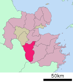 Location of Taketa in Ōita Prefecture | |
 Taketa Location in Japan | |
| Coordinates: 32°58′N 131°24′E | |
| Country | Japan |
| Region | Kyushu |
| Prefecture | Ōita Prefecture |
| Government | |
| • Mayor | Katsuji Syuto (since April 2009) |
| Area | |
| • Total | 477.59 km2 (184.40 sq mi) |
| Population (March 31, 2017) | |
| • Total | 22,661 |
| • Density | 47/km2 (120/sq mi) |
| Symbols | |
| • Tree | Maple Leaf |
| • Flower | Miyama Kirishima |
| • Bird | Cettia diphone |
| Time zone | UTC+9 (JST) |
| City hall address | Oji-Aiai 1650, Taketa City, Oita Prefecture (大分県竹田市大字会々1650番地) 878-8555 |
| Website | www |
As of March 31, 2017, the city has an estimated population of 22,661, with 10,393 households and a population density of 47 persons per km².[1] The total area is 477.59 km².
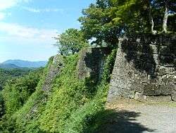
Oka Castle is a famous local historic site.
Notable people from Taketa
- Iwao Akiyama, former woodblock printmaker
- Korechika Anami, former general in the Imperial Japanese Army during World War II
- Kenji Anan, stage and film actor
- Takeo Hirose, former career officer in the Imperial Japanese Navy
- Otoya Kawano, voice actor
gollark: But you do need dates fairly often, and this makes it *consistent* between implementations.
gollark: For example, as well as the time-duration-type thing ("5y2mo3w" etc) it actually supports DD/MM/YYYY as well as some weird backward thing because it uses an external library for it too.
gollark: And even then it still has some weirdness.
gollark: Datetimes are very hard. AutoBotRobot has to do a bunch of stuff to make it do even roughly what people expect.
gollark: Although it does rely on JSON for encoding queries and sending results back, I guess.
References
- "Official website of Taketa city" (in Japanese). Japan: Taketa City. Retrieved 19 April 2017.
External links

- Official website (in Japanese)
Ōita (capital) | ||
| Core city |
| |
| Cities | ||
| Districts | ||
| Authority control |
|
|---|
This article is issued from Wikipedia. The text is licensed under Creative Commons - Attribution - Sharealike. Additional terms may apply for the media files.