Stupava (Uherské Hradiště District)
Stupava is a village and municipality (obec) in Uherské Hradiště District in the Zlín Region of the Czech Republic.
Stupava | |
|---|---|
Municipality | |
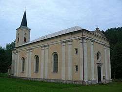 Saint Clement Church | |
 Flag  Coat of arms | |
 Stupava | |
| Coordinates: 49°7′11″N 17°15′18″E | |
| Country | |
| Region | Zlín |
| District | Uherské Hradiště |
| Area | |
| • Total | 7.1 km2 (2.7 sq mi) |
| Elevation | 345 m (1,132 ft) |
| Population (2008) | |
| • Total | 152 |
| • Density | 21/km2 (55/sq mi) |
| Postal code | 686 01 to 686 02 |
| Website | http://www.uh.cz/stupava/ |
The municipality covers an area of 7.1 square kilometres (2.7 sq mi), and has a population of 152 (as at 30 May 2008).
Stupava lies approximately 16 kilometres (10 mi) west of Uherské Hradiště, 33 km (21 mi) south-west of Zlín, and 231 km (144 mi) south-east of Prague.
This article is issued from Wikipedia. The text is licensed under Creative Commons - Attribution - Sharealike. Additional terms may apply for the media files.