Stanhope Gardens, New South Wales
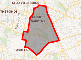
Stanhope Gardens is a suburb of Sydney, in the state of New South Wales, Australia. Stanhope Gardens is located 39 kilometres north-west of the Sydney central business district in the local government area of City of Blacktown. Stanhope Gardens is part of the Greater Western Sydney region, and is sometimes referred to as part of the Hills District.[2]
| Stanhope Gardens Sydney, New South Wales | |||||||||||||||
|---|---|---|---|---|---|---|---|---|---|---|---|---|---|---|---|
 Stanhope Village shopping centre | |||||||||||||||
| |||||||||||||||
| Population | 9,163 (2016 census)[1] | ||||||||||||||
| Established | 1996 | ||||||||||||||
| Postcode(s) | 2768 | ||||||||||||||
| Location | 31 km (19 mi) north-west of Sydney CBD | ||||||||||||||
| LGA(s) | Blacktown | ||||||||||||||
| State electorate(s) | Riverstone | ||||||||||||||
| Federal Division(s) | Greenway | ||||||||||||||
| |||||||||||||||
History
John Hillas (1768–1837) arrived in Australia in 1801 and received two land grants (in 1801 and 1804) on the Windsor Road. The second of these, of 150 acres, he named "Stanhope Farm". He established an inn, the Stanhope Arms on Windsor Road, to cater for the traffic between the Macquarie Towns and Parramatta.
By 1856 the Pearce family owned Stanhope Farm. In 1928 Jack Peel bought Stanhope Farm and called it Stanhope Park Dairy.
In 1973 the New South Wales Housing Commission compulsorily resumed Stanhope Park Dairy.
The suburb name reflects these early properties. Stanhope Gardens Estate opened in 1995 and was recognised as a suburb in 1996.[3]
When Stanhope Gardens was first being developed into what it is today, it was called Irish Town, Kellyville and Parklea. A petition was sent around with most people voting to keep Stanhope in the name, becoming Stanhope Gardens.
Newbury Estate - a master-planned estate - now occupies a large part of the suburb of Stanhope Gardens. Planned by Landcom, in 1999 Newbury Estate won the Royal Australian Planning Institute Award for Excellence in Plan Making - Urban Planning.[4] As a legacy site for Landcom no further support or investment is to be made. Leaving behind a mixed Community Title scheme with disconnected enclaves of Community and Neighbourhood Associations. Recently moves by the promoters of the North West Rail / Sydney Metro would see high rise development within the master planned estate.
Population
In the 2016 Census, there were 9,163 people in Stanhope Gardens. 53.9% of people were born in Australia. The next most common countries of birth were India 9.2%, Philippines 6.0%, England 2.5%, China 2.4% and New Zealand 1.9%. 55.6% of people spoke only English at home. Other languages spoken at home included Hindi 5.5%, Tagalog 3.2%, Mandarin 2.9%, Punjabi 2.6% and Filipino 2.0%. The most common responses for religion were Catholic 27.6%, No Religion 16.5%, Hinduism 11.8% and Anglican 10.9%. [1]
Commercial area
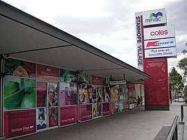
Stanhope Village is a sub-regional shopping centre anchored by a Coles supermarket, Liquorland and Kmart, ALDI supermarket and 40 other specialised retail, service, fashion and food outlets.[5] In March 2015 a redevelopment and extension of the centre was opened.
Transport
Public transport is provided by private bus operators Hillsbus and Busways, under contract from Transport for NSW. Services are available to Sydney CBD, Parramatta, Rouse Hill, Blacktown, Castle Hill, Pennant Hills and Epping.
The suburb is served by Riley Station on the Rouse Hill-Parramatta section of the North-West T-way, and Stanhope Station on the Blacktown- Parklea branch of the T-way.
The Sydney Metro Northwest provides high frequency services to Norwest Business Park, Castle Hill, Macquarie Park and Chatswood. Kellyville station is the closest to Stanhope Gardens.
Hillsbus routes 603 and 632 and Busways route 735 connect Stanhope Gardens with Kellyville station, whilst Busways route 745 connects to Bella Vista station. In addition Hillsbus route 663 and Busways route 731 connect to Rouse Hill station.
Eastbound services that serve Stanhope Gardens are (from 28 July 2019) :
From Riley T-way
- Route 651 to Epping via Kellyville, Castle Hill and Cherrybrook (Hillsbus)
- Route 665 to Parramatta via T-way. (Hillsbus)
- Route 735 to Blacktown via T-way. (Busways)
From Stanhope T-way
- Route 735 to Blacktown via T-way (Busways)
From Stanhope Village
- Route 616X, to Sydney CBD which goes via Glenwood, and the M2 Motorway. (Hillsbus)
- Route 663 to Parramatta via Glenwood and T-way (Hillsbus)
- Route 745 to Bella Vista via [[Glenwood, New South Wales|Glenwood] (Busways)
- Route 731 to Blacktown via Acacia Gardens and T-way (Busways)
- Route 734 to Blacktown via T-way
From Perfection Ave
- Route 603 to Parramatta via Kellyville station, Glenhaven, Castle Hill and Baulkham Hills (Hillsbus)
- Route 632 to Pennant Hills via Kellyville Station and Norwest Station (Hillsbus)
In the westbound direction:
From Riley T-way
- Route 651 to Rouse Hill Town Centre (Hillsbus)
- Route 665 to Rouse Hill Town Centre (Hillsbus)
- Route 735 to Rouse Hill and Riverstone. (Busways)
From Stanhope T-way
- Route 735 to Rouse Hill and Riverstone (Busways)
From Stanhope Village
- Route 616X serves Kellyville Ridge. (Hillsbus)
- Route 663 to Rouse Hill Town Centre via Kellyville Ridge (Hillsbus)
- Route 731 to Rouse Hill station (Busways)
- Route 745 to St Marys via Quakers Hill (Busways)
- Route 734 to Riverstone via The Ponds (Busways)
From Perfection Ave
- Route 603 to Rouse Hill Town Centre via Kellyville Ridge (Hillsbus)
- Route 632 to Rouse Hill Town Centre via Kellyville Ridge (Hillsbus)
Sport and recreation

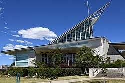
Blacktown Leisure Centre Stanhope, which is a fitness and swimming centre with wave pool and library. Located opposite the shopping centre, it is operated by the Blacktown City Council. This hosted the 2016 Women's Oceania Handball Championship in October 2016.
Places of worship
Stanhope Anglican Church meets in the function room of Blacktown Leisure Centre Stanhope on Sunday mornings.[6] The Catholic Parish of Blessed John XXIII holds services in the Church on Perfection Avenue, Stanhope Gardens. Attached to the Church is John 23rd Catholic Primary School (pre-school to Year 6), and St Marks Catholic Secondary College (years 7-12).
Politics
The suburb is in the Electoral district of Riverstone for the state of New South Wales. At Federal level, the suburb is located in the Division of Greenway.
References
- Australian Bureau of Statistics (27 June 2017). "Stanhope Gardens (State Suburb)". 2016 Census QuickStats. Retrieved 15 March 2018.

- Stanhope Gardens First National Real Estate North Western
- Blacktown City Council: Acacia Gardens, Glenwood, Parklea and Stanhope Gardens Timeline
- Newbury Estate
- Stanhope Village
- Stanhope Anglican Church
| Wikimedia Commons has media related to Stanhope Gardens, New South Wales. |