Sprout Creek
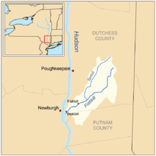
Sprout Creek is a 24.8-mile-long (39.9 km)[1] creek located entirely within Dutchess County, New York, United States.[2][3] It is the largest tributary of Fishkill Creek,[4] entering that creek some 11 miles (18 km) upstream from the Hudson River.[1][5] The creek is annually stocked with 6,000 brown trout, and maintains its own natural population of trout.

Course
Sprout Creek begins in Millbrook, at 755 feet (230 m) in elevation.[6] Paralleling Oak Summit Road, the creek flows generally southward towards New York State Route 82, where it passes through Verbank. The creek turns towards the west, though after reaching Verbank Village, it resumes its southwestern course. It turns around several small hills and mountains, and later intersects New York State Route 55. Shortly thereafter, Sprout Creek crosses the Taconic State Parkway;[7] it soon receives Jackson Creek.[2] The Jackson Creek watershed covers 5,524 acres (2,235 ha) of land, draining a large portion of Union Vale into Sprout Creek,[8] and has a small annual stocking of around 700 brown trout.[9] Sprout Creek continues generally towards the southwest, and later towards the south, before once again passing under Route 82. The bridge over the creek, located in the town of Fishkill, was built in 1934. At 85 ft (26 m) long, the bridge carried an AADT of 19,400 vehicles as of February 2006.[10] In 1772, Albanian engineer William Verplanck constructed a dam across the creek. He also built a grinding mill on the creek's banks; during the American Revolution, this mill ground a large quantity of grain for the soldiers stationed at Fishkill.[11] The creek ends at the Fishkill Creek, just north of New York State Route 52.[7] Sprout Creek also passes through Sprout Creek Farm, an educational farm, in the town of LaGrange within the city of Poughkeepsie.
Watershed
Comprising 24% of the overall Fishkill Creek watershed, the Sprout Creek subwatershed encompasses about 46 square miles (120 km2) of land—of which 17% was being used for agricultural purposes in 2000.[12] The creek's quality is described as "good" by the Fishkill Creek Watershed Committee, though agricultural operations, sewer treatment plants, and septic systems led to pollution at certain times during a study from 1973 to 2002.[13] It drains portions of La Grange, Union Vale, Wappinger, and East Fishkill.[4]
One of only three trout creeks in Dutchess County, the creek is annually stocked with 6,000 brown trout; wild trout are also present.[14][15] A group of local residents formed the Sprout Creek Association, after the operation of a nearby rock mine prompted concerns about the creek's environmental health.[15]
References
- U.S. Geological Survey. National Hydrography Dataset high-resolution flowline data. The National Map, accessed October 3, 2011
- Eric H. Newman (2002). Flyfisher's Guide to New York. Wilderness Adventures Press. p. 148. ISBN 1-885106-92-0.
- William Hubert Burr (1904). Report of the Commission on additional water supply for the city of New York. University of Wisconsin. p. 462.
- "Natural Resources Management Plan For The Fishkill Creek Watershed" (PDF). Fishkill Creek Watershed Committee. Archived from the original (PDF) on August 27, 2008. Retrieved 2009-04-09.
- Smith, Joseph Mather (1860). Report on the medical topography and epidemics of the state of New York. Collins. p. 122.
- "Fishkill Creek Watershed Education Program" (PDF). Fishkill Creek Watershed Committee. Retrieved 2009-04-09.
- Map of Sprout Creek (Map). Cartography by NAVTEQ. Google Maps. 2009. Retrieved 2009-04-09.
- "The Jackson Creek Streamwalk, 2007" (PDF). Fishkill Creek Watershed Committee. Archived from the original (PDF) on January 6, 2009. Retrieved 2009-04-09.
- Newman, Eric H. (2002). Flyfisher's Guide to New York. Wilderness Adventures Press. p. 148. ISBN 1-885106-92-0.
- Osman Hag-Elsafi and Jonathan Kunin (2006). "Load Testing For Bridge Rating: Route 82 Over Sprout Creek" (PDF). New York State Department of Transportation. Retrieved 2009-05-02.
- Mills, Malcolm J. (2006). East Fishkill. Arcadia Publishing. p. 109. ISBN 0-7385-4460-4.
- "Sprout Creek". Fishkill Creek Watershed Committee. Retrieved 2009-04-09.
- "Fishkill Creek Watershed Management Plan". Fishkill Creek Watershed Committee. Archived from the original on 2007-06-19. Retrieved 2009-04-09.
- "Public Fishing Rights Maps: Sprout Creek" (PDF). New York State Department of Environmental Conservation. Retrieved 2009-04-09.
- Staff Writer (2004). "LaGrange's mining experience holds lessons for Milan's future". The Register Herald. Retrieved 2009-05-02.
External links
| Wikimedia Commons has media related to Sprout Creek. |