Platter Kill
The Platter Kill's 11-square-mile (28 km2)[2] watershed accounts for about 1.2 percent of the Schoharie basin.
| Platter Kill | |
|---|---|
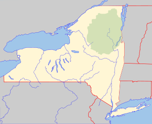
 Location of mouth within New York  Platter Kill (the United States) | |
| Location | |
| Country | United States |
| State | New York |
| County | Schoharie |
| Physical characteristics | |
| Source | |
| • coordinates | 42°27′52″N 74°23′18″W[1] |
| Mouth | Schoharie Creek |
• coordinates | 42°24′19″N 74°27′03″W[1] |
• elevation | 932 ft (284 m)[1] |
| Length | 24.8 mi (39.9 km) |
| Basin size | 11 sq mi (28 km2)[2] |
Platter Kill is a tributary of Schoharie Creek.
Hydrology

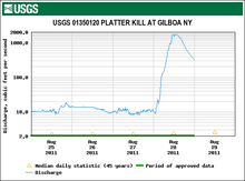
Graph from Gilboa USGS stream gauge showing rise in discharge after Tropical Storm Irene
The United States Geological Survey (USGS) has maintained one stream gauge along Platter Kill in operation since 1975. The station located 0.6 miles (0.97 km) northwest of Gilboa, had a maximum discharge of 1,750 cubic feet (50 m3) per second on August 28, 2011, as Hurricane Irene passed through the area, and a minimum discharge of 0.31 cubic feet (0.0088 m3) per second on March 11, 2015.[3]
gollark: Interesting. Very interesting.
gollark: What is big narf? Bees enabled.
gollark: But you can still access the main content, and osmarks internet radio™, and the random stuff API!
gollark: osmarks.tk now has a yggdrasil subdomain with its AAAA record pointed at my yggdrasil IP, so all zero people using that can now connect to a (HTTP-only, missing many backend services) osmarks.tk!
gollark: Anyway, so you can... peer with me? and access osmarks.tk.
References
- "Platter Kill". Geographic Names Information System. United States Geological Survey. Retrieved May 5, 2020.
- "Platter Kill at Mouth at Gilboa NY". usgs.gov. United States Geological Survey. Retrieved 5 May 2020.
- "USGS 01350120 PLATTER KILL AT GILBOA NY". United States Geological Survey. Retrieved 5 May 2020.
This article is issued from Wikipedia. The text is licensed under Creative Commons - Attribution - Sharealike. Additional terms may apply for the media files.