Simpsonville, Kentucky
Simpsonville is a home rule-class city[4] in Shelby County, Kentucky, in the United States. It is located 8 miles west of Shelbyville, Kentucky and 23 miles east of Louisville situated along U.S. 60.[5] The population was 2,484 during the 2010 U.S. Census.[6]
City of Simpsonville | |
|---|---|
City | |
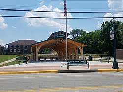
 Pavilion at Fred Wiche Park In Simpsonville, Kentucky | |
| Nickname(s): American Saddlebred Horse Capital of the World | |
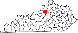
 Location of Simpsonville in Shelby County, Kentucky. | |
| Coordinates: 38°13′6″N 85°21′11″W | |
| Country | United States |
| State | Kentucky |
| County | Shelby |
| Incorporated | 1833[1] |
| Named for | John Simpson |
| Government | |
| • Type | City Commission |
| • Mayor | Cary T. Vowels |
| Area | |
| • Total | 2.38 sq mi (6.15 km2) |
| • Land | 2.35 sq mi (6.09 km2) |
| • Water | 0.02 sq mi (0.06 km2) |
| Elevation | 797 ft (243 m) |
| Population (2010) | |
| • Total | 2,484 |
| • Estimate (2019)[3] | 2,923 |
| • Density | 1,242.24/sq mi (479.72/km2) |
| Time zone | UTC−5 (Eastern (EST)) |
| • Summer (DST) | UTC−4 (EDT) |
| ZIP code | 40067 |
| Area code(s) | 502 |
| FIPS code | 21-70752 |
| GNIS feature ID | 0503542 |
| Interstates | |
| Website | www |
Early history

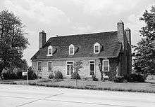
Simpsonville was first laid out in 1816, received its first post office in 1821,[7] and was incorporated in 1833. It was named in honor Captain John Simpson; a native Virginian who represented Shelby County in the Kentucky House of Representatives and died in the War of 1812. By 1825 it had become a stage coach town; one of the largest between Shelbyville and Louisville.[5] The Midland trail stagecoach would either swap out or rest their horses and travelers could stay at the Old Stone Inn. The second oldest stone building in the county which is still standing today.[8]
For most of its history Simpsonville was an agrarian community which dairy, tobacco, cattle, and hogs being the primary source of income for most residents.[5] This was due to its remarkably fertile soil based on limestone and red clay.[9] Later on it would be the genesis for the town's moniker 'American Saddlebred Horse Capital of the World'.[5]
Civil War
In January 1865 at least 80 members of Company E of the 5th United States Colored Cavalry were transporting 900 head of Federal cattle from Camp Nelson to a stock market in Louisville.[10] They set up camp in Simpsonville and on the morning of January 25 they were attacked by Confederate guerrillas believed to be led by Henry Magruder.[11] The guerrillas attacked from the rear killing 22 Union soldiers and injuring over 20 more, some of which were killed after trying to surrender.[12] The Union army camped in Louisville was indifferent to the ambush, not responding for three days and leaving the citizens of Simpsonville to care for the wounded.[13] The citizens of Simpsonville buried the dead in two mass graves that later became an African American cemetery,[12] one of which is now marked with a memorial along U.S. 60.
Geography
Simpsonville is located at 38°13′6″N 85°21′11″W (38.218373, -85.353058).[14] According to the United States Census Bureau, the city has a total area of 1.3 square miles (3.4 km2), of which 1.3 square miles (3.4 km2) is land and 0.04 square miles (0.10 km2) (1.50%) is water.
Education

Early in its history Simpsonville had several one-room schools[5] including Professor John W. Adams' school in the 1850s and Jordans Fairview Academy from 1868 to 1880.[15] By 1895 it had four private schools and its first public high school (Simpsonville High School) was built in 1912.[5] In the following decades the high school was merged with Todd's Point in 1940[16] and Finchville High School in 1950.[17] The high school closed its doors in 1958 when Shelby County decided to consolidate its school system and it became Simpsonville Elementary school.[5] Today Simpsonville is served by the Shelby County Public School system with its residents attending Martha Layne Collins High School in Shelbyville. There is also one private that serves all grades: Corpus Christi Academy.[18]
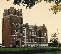
Following the Civil War all Kentucky schools were segregated. Simpsonville's African-American children attended Simpsonville School and Lincoln Model School.[19] Simpsonville was also the site of the Lincoln Institute; a boarding school for African American founded in 1912. It was built by Berea College in response to the Day Law which forced segregation of all public and private educational facilities. It offered both high school and vocational training until 1966 when declining enrollment caused by Brown v. Board of Education forced it to close. Today the grounds serve as the Whitney M. Young, Jr. Job Corps Training Center.[20]
Demographics
| Historical population | |||
|---|---|---|---|
| Census | Pop. | %± | |
| 1830 | 77 | — | |
| 1850 | 225 | — | |
| 1860 | 169 | −24.9% | |
| 1870 | 239 | 41.4% | |
| 1880 | 253 | 5.9% | |
| 1890 | 290 | 14.6% | |
| 1900 | 203 | −30.0% | |
| 1910 | 185 | −8.9% | |
| 1920 | 189 | 2.2% | |
| 1930 | 181 | −4.2% | |
| 1940 | 220 | 21.5% | |
| 1950 | 247 | 12.3% | |
| 1960 | 220 | −10.9% | |
| 1970 | 628 | 185.5% | |
| 1980 | 642 | 2.2% | |
| 1990 | 907 | 41.3% | |
| 2000 | 1,281 | 41.2% | |
| 2010 | 2,484 | 93.9% | |
| Est. 2019 | 2,923 | [3] | 17.7% |
| U.S. Decennial Census[21] | |||
As of the census[22] of 2010, there were 2,484 people, 935 households, and 672 families residing in the city. The population density was 980.9 people per square mile (377.6/km2). There were 935 housing units at an average density of 395.9 per square mile (152.4/km2). The racial makeup of the city was 89.89% White, 6.80% African American, 0.52% Native American, 2.09% Asian, 2.86% from other races, and 2.13% from two or more races. Hispanic or Latino of any race were 8.98% of the population.
There were 935 households, out of which 40.7% had children under the age of 18 living with them, 53.9% were married couples living together, 13.3% had a female householder with no husband present, and 28.1% were non-families. 24.0% of all households were made up of individuals, and 7.5% had someone living alone who was 65 years of age or older. The average household size was 2.66 and the average family size was 3.17.
In the city, the population was spread out, with 30.6% under the age of 18, 5.9% from 18 to 24, 32.3% from 25 to 44, 22.0% from 45 to 64, and 9.2% who were 65 years of age or older. The median age was 33.3 years. For every 100 females, there were 90.3 males. For every 100 females age 18 and over, there were 86.4 males.
The median income for a household in the city was $45,000, and the median income for a family was $52,560. Males had a median income of $34,688 versus $27,431 for females. The per capita income for the city was $17,443. About 7.7% of families and 6.5% of the population were below the poverty line, including 6.3% of those under age 18 and 7.2% of those age 65 or over.
References
- Commonwealth of Kentucky. Office of the Secretary of State. Land Office. "Simpsonville, Kentucky". Accessed 26 August 2013.
- "2019 U.S. Gazetteer Files". United States Census Bureau. Retrieved July 24, 2020.
- "Population and Housing Unit Estimates". United States Census Bureau. May 24, 2020. Retrieved May 27, 2020.
- "Summary and Reference Guide to House Bill 331 City Classification Reform" (PDF). Kentucky League of Cities. Retrieved December 30, 2014.
- Henninger, Hobie; Jelsma, Sherry (2003). "Chapter 2 Communities; Simpsonville". In Kleber, John (ed.). The New History of Shelby County, Kentucky. Harmony House Publishers. pp. 85–87. ISBN 978-1-564-69096-8.
- https://www.census.gov/geo/maps-data/data/docs/gazetteer/2010_place_list_21.txt
- Elbon, David C. (2018). "Simpsonville, Kentucky". www.kyatlas.com. Kentucky Atlas and Gazetteer. Retrieved August 13, 2018.
- Carpenter, George Ann (2003). "Chapter 8 Transportation; Taverns". In Kleber, John (ed.). The New History of Shelby County, Kentucky. Harmony House Publishers. p. 384. ISBN 978-1-564-69096-8.
- Van Stockum Sr., R. R. (2003). "Chapter 2 Communities; Shelby County". In Kleber, John (ed.). The New History of Shelby County, Kentucky. Harmony House Publishers. p. 74. ISBN 978-1-564-69096-8.
- Sanders. "Simpsonville Massacre". explorekyhistory.ky.gov/. ExploreKYHistory. Retrieved July 14, 2017.
- Bummer (February 22, 2013). "Civil War Bummer". www.civilwarbummer.com/. Retrieved July 14, 2017.
- West, Joyce (August 11, 2015). "Honoring a Forgotten Chapter in Kentucky's Civil War History". www.ket.org/. KET. Retrieved July 14, 2017.
- Glasser, Paul (February 3, 2009). "Simpsonville Civil War Massacre". www.armchairgeneral.com/. Retrieved July 14, 2017.
- "US Gazetteer files: 2010, 2000, and 1990". United States Census Bureau. 2011-02-12. Retrieved 2011-04-23.
- Willis, George Lee (1979) [First published 1929]. Willis, George Lee (ed.). The History of Shelby County. Utica, KY: Cook & McDowell Publications. p. 109. ISBN 0806346469. Retrieved February 16, 2018.
- Long, Charles T. (2003). "Chapter 2 Communities; Todd's Point". In Kleber, John (ed.). The New History of Shelby County, Kentucky. Harmony House Publishers. p. 89. ISBN 978-1-564-69096-8.
- Long, Charles T. (2003). "Chapter 2 Communities; Finchville". In Kleber, John (ed.). The New History of Shelby County, Kentucky. Harmony House Publishers. p. 66. ISBN 978-1-564-69096-8.
- "School History". www.corpuschristiclassical.com/. Corpus Christi Classical Academy. Retrieved July 14, 2017.
- Collins, Kevin (2003). "Chapter 6 Education and Schools; African-American education". In Kleber, John (ed.). The New History of Shelby County, Kentucky. Harmony House Publishers. pp. 279–284. ISBN 978-1-564-69096-8.
- Talbot, Tim. "Simpsonville Massacre". explorekyhistory.ky.gov/. ExploreKYHistory. Retrieved July 14, 2017.
- "Census of Population and Housing". Census.gov. Retrieved June 4, 2015.
- "U.S. Census website". United States Census Bureau. Retrieved 2017-07-06.
