San Giacomo Filippo
San Giacomo Filippo (Alpine Lombard: San Giacum) is a comune (municipality) in the Province of Sondrio in the Italian region Lombardy, located about 100 kilometres (62 mi) north of Milan and about 45 kilometres (28 mi) northwest of Sondrio, on the border with Switzerland. As of 31 December 2004, it had a population of 453 and an area of 62.1 square kilometres (24.0 sq mi).[3]
San Giacomo Filippo | |
|---|---|
| Comune di San Giacomo Filippo | |
Location of San Giacomo Filippo 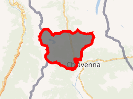
| |
 San Giacomo Filippo Location of San Giacomo Filippo in Italy 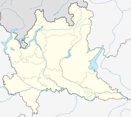 San Giacomo Filippo San Giacomo Filippo (Lombardy) | |
| Coordinates: 46°20′N 9°22′E | |
| Country | Italy |
| Region | Lombardy |
| Province | Province of Sondrio (SO) |
| Frazioni | San Bernardo ai Monti, Olmo, Sommarovina, Sant'Antonio di Albareda, Dalò, Uggia, Gallivaggio, Lirone, Cimaganda, Vho |
| Area | |
| • Total | 62.1 km2 (24.0 sq mi) |
| Elevation | 679 m (2,228 ft) |
| Population (Dec. 2004)[2] | |
| • Total | 453 |
| • Density | 7.3/km2 (19/sq mi) |
| Demonym(s) | Filippesi |
| Time zone | UTC+1 (CET) |
| • Summer (DST) | UTC+2 (CEST) |
| Postal code | 23020 |
| Dialing code | 0343 |
The municipality of San Giacomo Filippo contains the frazioni (subdivisions, mainly villages and hamlets) San Bernardo ai Monti, Olmo, Sommarovina, Sant'Antonio di Albareda, Dalò, Uggia, Gallivaggio, Lirone, Cimaganda, Vho.
San Giacomo Filippo borders the following municipalities: Campodolcino, Chiavenna, Menarola, Mese, Mesocco (Switzerland), Piuro, Soazza (Switzerland).
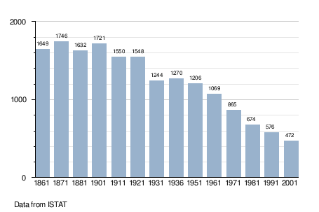
Demographic evolution
References
- "Superficie di Comuni Province e Regioni italiane al 9 ottobre 2011". Istat. Retrieved 16 March 2019.
- Istat, Wikidata Q214195
- All demographics and other statistics: Italian statistical institute Istat.