Hammond Parish, New Brunswick
Hammond is a civil parish[lower-alpha 1] in Kings County, New Brunswick, Canada.
Hammond | |
|---|---|
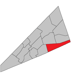 Location within Kings County, New Brunswick. | |
| Coordinates: 45.84°N 64.59°W | |
| Country | |
| Province | |
| County | Kings County |
| Established | 1786 |
| Area | |
| • Land | 244.45 km2 (94.38 sq mi) |
| Population (2016)[1] | |
| • Total | 251 |
| • Density | 1.0/km2 (3/sq mi) |
| • Change 2011-2016 | |
| • Dwellings | 153 |
| Time zone | UTC-4 (AST) |
| • Summer (DST) | UTC-3 (ADT) |
History
Hammond Parish formed in 1858 from part of Upham Parish. It was named for the Hammond River.
Delineation
Hammond Parish is defined in the Territorial Division Act[2] as being bounded:
- Northerly by Sussex and Waterford Parishes; south and east by the County lines, and west by Upham Parish.
Governance
The entire parish forms the local service district of the parish of Hammond, established in 1968 to assess for fire protection. First aid and ambulance services were added to the assessment in 1972. Recreational facilities were added to the assessment in 1994, with first aid and ambulance services being removed at the same time.
Communities
Parish population total does not include incorporated municipalities (in bold):
|
|
Bodies of water & Islands
This is a list of rivers, lakes, streams, creeks, marshes and Islands that are at least partially in this parish
Demographics
Access Routes
Highways and numbered routes that run through the parish, including external routes that start or finish at the parish limits:[5]
See also
Notes
- Civil parishes served a variety of government functions until 1966, when the new Municipalities Act stripped them of their responsibilities; they continue to provide convenient boundaries for government uses, especially electoral districts and local service districts. Statistics Canada uses civil parishes as census subdivisions for all parts of the province that are not within municipalities and similar entities.
References
- "Census Profile, 2016 Census: Hammond, Parish [Census subdivision], New Brunswick". Statistics Canada. Retrieved September 19, 2019.
- "Territorial Division Act (R.S.N.B. 1973, c. T-3)". Government of New Brunswick website. Retrieved 23 August 2016.
- Statistics Canada: 2001, 2006 census
- 2011 Statistics Canada Census Profile: Hammond Parish, New Brunswick
- Atlantic Canada Back Road Atlas ISBN 978-1-55368-618-7
Places adjacent to Hammond Parish, New Brunswick | ||||||||||
|---|---|---|---|---|---|---|---|---|---|---|
| ||||||||||
| Subdivisions |
|
|---|---|
| Cities | |
| Counties | |
| |