Saint Croix Parish, New Brunswick
Saint Croix is a civil parish in Charlotte County, New Brunswick, Canada,[3] straddling Route 1 to the north of Saint Andrews, New Brunswick. Its name comes from the Saint Croix River, which forms part of its western border.
Saint Croix St. Croix | |
|---|---|
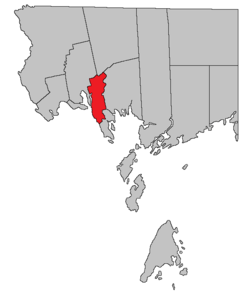 Location within Charlotte County. | |
| Country | |
| Province | |
| County | Charlotte County |
| Erected | 1874 |
| Named for | Saint Croix River |
| Area | |
| • Land | 78.67 km2 (30.37 sq mi) |
| Population (2016)[1] | |
| • Total | 657 |
| • Density | 8.4/km2 (22/sq mi) |
| • Pop 2011-2016 | |
| • Dwellings | 368 |
| Time zone | UTC-4 (AST) |
| • Summer (DST) | UTC-3 (ADT) |
| Highways | Route 1 / Route 127 / Route 170 / Route 760[2] |
For governance purposes it is divided into two local service districts.[4]
The Census subdivision of the same name[1] includes the entire parish, while the LSD of Bayside is used as a Designated place.[5]
History
Saint Croix Parish was created in 1874 from the northern part of Saint Andrews Parish.[6]
Boundaries
External Boundaries
Saint Croix has the most irregular boundaries in Charlotte County, taking in an area based on land grants along and near Route 127, Cathcart Road, and Waweig Road to the north of Route 1 and along Frye Road and Chamcook and Little Chamcook Lakes to the south.
Official Delineation
The entire parish can be found on New Brunswick Cadastral Map No. 161.[7]
Saint Croix Parish is defined in the Territorial Division Act[3] as being bounded:[lower-alpha 1]
- East and South[lower-alpha 2] by a line beginning at the most Northern angle of a four hundred and eighty-eight acre lot, granted to Daniel Hill, on Waweig River;
- thence Southeasterly, along the Northeastern limit of said lot, to the Western angle of Lot No. 3, granted to James McFarlane;
- thence Northeasterly, along the Northwestern limit of Lot No. 3, to the Northern angle of same;
- thence Southeasterly, along the Northeastern limit of Lots Numbered 3, 2, 1 and 12 and of Lot No. 13, granted to John H. Armstrong, to the Eastern angle of Lot No. 13;
- thence Southwesterly, along the Southeastern limit of Lot No. 13, to the Northeastern limit of the grant to William Reading;
- thence Southeasterly, along the Northeastern limit of the grant to William Reading to the Eastern angle of same;
- thence Southwesterly, along the Southeastern limit of the grant to William Reading, to the Northeastern limit of the grant to Rachael Mowat;
- thence Southeasterly, along said Northeastern limit to the Eastern angle of same;
- thence Southwesterly, along the Southeastern limit of lot granted to Rachael Mowat and of Lots Numbered 9, 8, 7, 6 and 5 to the Northeastern limit of Lot No. 4 granted to Maxwell Lawry;
- thence Southeasterly along said Northeastern limit of Lot No. 4, to the Eastern angle of same;
- thence Southwesterly along the Southeastern limit of Lots Numbered 4, 3 and 2 to the Southern angle of Lot 2, granted to Lauchlan Doon;
- thence Northwesterly along the Southwestern limit of Lot No. 2 to the Southeastern limit of Lot No. 28, granted to Moses J. Greenlaw;
- thence Southwesterly, along the Southeastern limit of Lot No. 28 to the Northeastern angle of Lot 29, granted to Jesse C. Bartlett;
- thence Southerly, along the Eastern limit of lot 29, to the Northwestern angle of Lot No. 45, granted to Jesse C. Bartlett;
- thence Easterly along the Northern limit of Lot 45 to the Northeastern angle of same;
- thence Southerly, along the Eastern limit of Lot 45, to the Northern limit of the hundred acre lot granted to Andrew Dougherty;
- thence Easterly, along the said Northern limit to the Western bank or shore of Bonaparte Lake;
- thence Southerly, along said bank or shore, to meet the Northerly prolongation of the Eastern limit of Lot No. 4 granted to Leonard Bartlett;
- thence Southerly along said prolongation and said limit to the Northern limit of Lot No. 3 granted to Thomas Sime;
- thence Westerly along said Northern limit to the Northwestern angle of Lot No. 3;
- thence Southerly, along the Western limit of Lots Numbered 3, 2 and 1 to the Southeastern angle of Lot No. 11 granted to James Greenlaw;
- thence Westerly, along the Southern limit of Lot No. 11, to the Eastern bank or shore of Little Chamcook Lake;
- thence Southerly along the Eastern bank or shore of Little Chamcook Lake and the Eastern bank or shore of Fry Mill Stream to the bank or shore of Chamcook Lake;
- thence Southerly, Westerly and Northerly along the Eastern, Southern and Western banks or shores of Chamcook Lake to the Northern limit of the five hundred acre lot granted to Colin Campbell, Thomas Wyer and William Gallop;
- thence Westerly, along said Northern limit, to the Eastern limit of lots fronting on the St. Croix River;
- thence Southerly along the Eastern limit of lots fronting on the St. Croix River to the Southeastern angle of Lot No. 38 granted to Daniel Grant;
- thence Westerly along the Southern limit of lot 38 to the St. Croix River;
- West by the St. Croix River and Saint David Parish, [From the Saint Croix starting point, it runs southwesterly, crosses the Board Road twice, then runs along Route 760 nearly to its intersection with Board Road before turning south to the Waweig River.][lower-alpha 3]
- North by Saint David Parish[lower-alpha 4]
- including Rickets Island in Waweig River.[lower-alpha 5]
Internal Boundaries
- Bayside (LSD) comprises all of the mainland south of Route 1 and assesses for Community & Recreation Services[8] in addition to basic LSD services.[lower-alpha 6]
- the parish of Saint Croix (LSD) comprises the mainland north of Route 1 plus Rickets Island; it assesses only for basic services.
Census data
Population
| Canada census – Saint Croix Parish, New Brunswick community profile | |||
|---|---|---|---|
| 2016 | 2011 | 2006 | |
| Population: | 657 (+6.7% from 2011) | 616 (-8.1% from 2006) | 670 (+5.7% from 2001) |
| Land area: | 78.67 km2 (30.37 sq mi) | 78.77 km2 (30.41 sq mi) | 78.67 km2 (30.37 sq mi) |
| Population density: | 8.4/km2 (22/sq mi) | 7.8/km2 (20/sq mi) | 8.5/km2 (22/sq mi) |
| Median age: | 48.1 (M: 49.5, F: 46.3) | 45.2 (M: 45.8, F: 45.0) | 43.0 (M: 43.4, F: 41.5) |
| Total private dwellings: | 368 | 322 | 353 |
| Median household income: | $55,040 | $45,812 | $38,485 |
| References: 2016[9] 2011[10] 2006[11] earlier[12] | |||
|
|
| ||||||||||||||||||||||||||||||
(A) adjustment due to boundary change. [13][1] | ||||||||||||||||||||||||||||||||
Language
| Canada Census Mother Tongue - Saint Croix Parish, New Brunswick[13] | ||||||||||||||||||
|---|---|---|---|---|---|---|---|---|---|---|---|---|---|---|---|---|---|---|
| Census | Total | English |
French |
English & French |
Other | |||||||||||||
| Year | Responses | Count | Trend | Pop % | Count | Trend | Pop % | Count | Trend | Pop % | Count | Trend | Pop % | |||||
2011 |
610 |
590 | 96.72% | 10 | 1.64% | 0 | 0.00% | 10 | 1.64% | |||||||||
2006 |
665 |
655 | 98.50% | 0 | 0.00% | 0 | 0.00% | 10 | 1.50% | |||||||||
2001 |
635 |
620 | 97.64% | 15 | 2.36% | 0 | 0.00% | 0 | 0.00% | |||||||||
1996 |
660 |
650 | n/a | 98.48% | 10 | n/a | 1.52% | 0 | n/a | 0.00% | 0 | n/a | 0.00% | |||||
Communities
Communities at least partly within the parish.[14] Names in italics appear on grant maps[7] but not on highway maps.
Bodies of water
Bodies of water at least partly within the parish.[14]
|
|
|
Islands
Islands at least partly within the parish.[14]
- Big Rock (in Chamcook Lake)
- Odell Island (in Chamcook Lake)
- Rickets Island (in Waweig River)
See also
Notes
- Description changed to bullet points for readability
- The wording could easily be misunderstood. The line starts at a northern corner of the parish and runs briefly easterly before turning south.
- "[...] commencing at the most northern angle of a four hundred and eighty-eight acre lot granted to Daniel Hill on Waweig River; thence southwesterly to the most western angle of the said lot; thence southeasterly to the northeast angle of lot number thirty, granted to W. Ross; thence westerly along the north line of the said last-mentioned grant and its western prolongation to the northeast angle of lot number eight, granted to James Garcelon; thence south to the southeast angle of lot number four, granted to James Christie; thence west to the southwest angle of the said last-mentioned lot; thence south along the eastern line of lots fronting on Oak Bay to Waweig River; thence down the channel of Waweig River [...]
- This clause is redundant, as the early clauses cover this part of the boundary.
- Lack of punctuation makes it appear Rickets Island is part of St. David Parish, but that parish's description explicitly excludes the island.
- Firefighting, policing, zoning, EMO, and dog control, along with administrative costs.
References
- "Census Profile, 2016 Census Saint Croix, Parish [Census subdivision], New Brunswick". Statistics Canada. Retrieved 30 August 2019.
- Atlantic Canada Back Road Atlas ISBN 978-1-55368-618-7 Pages 4, 12
- "Chapter T-3 Territorial Division Act". Government of New Brunswick. Retrieved 26 July 2020.
- "New Brunswick Regulation 84-168 under the Municipalities Act (O.C. 84-582)". Government of New Brunswick. Retrieved 26 July 2020.
- "Census Profile, 2016 Census". Statistics Canada. Retrieved 28 July 2020.
- Acts of the General Assembly of Her Majesty's Province of New Brunswick passed in the months of March & April 1874. Fredericton: G.E. Fenety, Printer to the Queen's Most Excellent Majesty. 1874. pp. 109–111. Book is available as free download from Google Books.
- "No. 161". Provincial Archives of New Brunswick. Government of New Brunswick. Retrieved 27 July 2020.
- "2019 Local Government Statistics for New Brunswick" (PDF). Department of Environment and Local Government. p. 59. Retrieved 28 July 2020.
- "2016 Community Profiles". 2016 Canadian Census. Statistics Canada. 21 February 2017. Retrieved 30 August 2019.
- "2011 Community Profiles". 2011 Canadian Census. Statistics Canada. 5 July 2013. Retrieved 16 March 2014.
- "2006 Community Profiles". 2006 Canadian Census. Statistics Canada. 30 March 2011. Retrieved 16 March 2014.
- "2001 Community Profiles". 2001 Canadian Census. Statistics Canada. 17 February 2012.
- Statistics Canada: 1996, 2001, 2006, 2011 census
- "479" (PDF). Province of New Brunswick. Retrieved 27 July 2020."489" (PDF). Province of New Brunswick. Retrieved 27 July 2020.
Places adjacent to Saint Croix Parish, New Brunswick | |
|---|---|
| Subdivisions |
|
|---|---|
| Cities | |
| Counties | |
| |