Saint-Léger-de-Peyre
Saint-Léger-de-Peyre (Occitan: Sent Latgièr de Peire) is a commune in the Lozère department in southern France.
Saint-Léger-de-Peyre | |
|---|---|
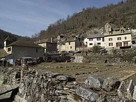 The village of St-Léger-de-Peyre in the Colagne valley, north of Marvejols | |
Location of Saint-Léger-de-Peyre 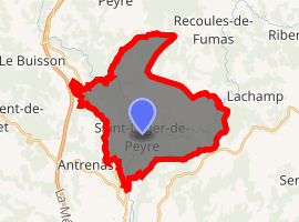
| |
 Saint-Léger-de-Peyre  Saint-Léger-de-Peyre | |
| Coordinates: 44°35′43″N 3°18′07″E | |
| Country | France |
| Region | Occitanie |
| Department | Lozère |
| Arrondissement | Mende |
| Canton | Marvejols |
| Intercommunality | Gévaudan |
| Government | |
| • Mayor (2008–2014) | Jean-Paul Itier |
| Area 1 | 27.35 km2 (10.56 sq mi) |
| Population (2017-01-01)[1] | 187 |
| • Density | 6.8/km2 (18/sq mi) |
| Time zone | UTC+01:00 (CET) |
| • Summer (DST) | UTC+02:00 (CEST) |
| INSEE/Postal code | 48168 /48100 |
| Elevation | 670–1,154 m (2,198–3,786 ft) (avg. 720 m or 2,360 ft) |
| 1 French Land Register data, which excludes lakes, ponds, glaciers > 1 km2 (0.386 sq mi or 247 acres) and river estuaries. | |
Geography
The Colagne flows southwestward through the southern part of the commune and crosses the village.
gollark: It relies on Switchcraft, which people seem fine with.
gollark: Er. Hmm.
gollark: So do modems!
gollark: It can be self-hosted, and the library quite easily allows switching servers.
gollark: Because it's cross-server, doesn't require modems, does away with legacy junk like replyChannel, and supports stringy channels.
See also
References
- "Populations légales 2017". INSEE. Retrieved 6 January 2020.
| Wikimedia Commons has media related to Saint-Léger-de-Peyre. |
| Authority control |
|
|---|
This article is issued from Wikipedia. The text is licensed under Creative Commons - Attribution - Sharealike. Additional terms may apply for the media files.