Saint-Étienne-la-Geneste
Saint-Étienne-la-Geneste is a commune in the Corrèze department in central France.
Saint-Étienne-la-Geneste | |
|---|---|
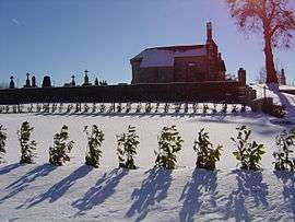 The church in Saint-Étienne-la-Geneste | |
.svg.png) Coat of arms | |
Location of Saint-Étienne-la-Geneste 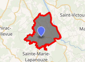
| |
 Saint-Étienne-la-Geneste  Saint-Étienne-la-Geneste | |
| Coordinates: 45°26′50″N 2°20′47″E | |
| Country | France |
| Region | Nouvelle-Aquitaine |
| Department | Corrèze |
| Arrondissement | Ussel |
| Canton | Haute-Dordogne |
| Intercommunality | Haute-Corrèze Communauté |
| Government | |
| • Mayor (2020–2026) | Christophe Tur |
| Area 1 | 5.01 km2 (1.93 sq mi) |
| Population (2017-01-01)[1] | 93 |
| • Density | 19/km2 (48/sq mi) |
| Time zone | UTC+01:00 (CET) |
| • Summer (DST) | UTC+02:00 (CEST) |
| INSEE/Postal code | 19200 /19160 |
| Elevation | 545–637 m (1,788–2,090 ft) (avg. 680 m or 2,230 ft) |
| 1 French Land Register data, which excludes lakes, ponds, glaciers > 1 km2 (0.386 sq mi or 247 acres) and river estuaries. | |
Geography
The river Diège forms all of the commune's eastern boundary.
Population
| Year | Pop. | ±% |
|---|---|---|
| 1962 | 71 | — |
| 1968 | 85 | +19.7% |
| 1975 | 58 | −31.8% |
| 1982 | 55 | −5.2% |
| 1990 | 62 | +12.7% |
| 1999 | 61 | −1.6% |
| 2008 | 80 | +31.1% |
gollark: HTTP/2 predates the encrypted SNI thing, and indeed the latter is not really implemented many places yet.
gollark: ```osmarks@fenrir ~/Downloads> curl -I https://osmarks.tk/HTTP/2 200 server: nginx/1.18.0date: Mon, 09 Nov 2020 21:50:42 GMTcontent-type: text/htmlcontent-length: 11144last-modified: Mon, 21 Sep 2020 17:33:13 GMTetag: "5f68e3d9-2b88"strict-transport-security: max-age=63072000; preload; includeSubDomainsreferrer-policy: strict-origin-when-cross-originaccept-ranges: bytes```
gollark: 1. It is set up and works2. Encrypted SNI is a separate (TLS) thing
gollark: WRONG!
gollark: You cannot actually change my domain config.
See also
References
- "Populations légales 2017". INSEE. Retrieved 6 January 2020.
| Wikimedia Commons has media related to Saint-Étienne-la-Geneste. |
| Authority control |
|
|---|
This article is issued from Wikipedia. The text is licensed under Creative Commons - Attribution - Sharealike. Additional terms may apply for the media files.