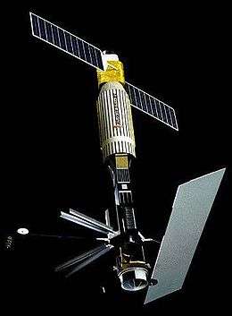
Seasat
Seasat[3] was the first Earth-orbiting satellite designed for remote sensing of the Earth's oceans and had on board the first spaceborne synthetic-aperture radar (SAR). The mission was designed to demonstrate the feasibility of global satellite monitoring of oceanographic phenomena and to help determine the requirements for an operational ocean remote sensing satellite system. Specific objectives were to collect data on sea-surface winds, sea-surface temperatures, wave heights, internal waves, atmospheric water, sea ice features and ocean topography. Seasat was managed by NASA's Jet Propulsion Laboratory and was launched on 27 June 1978 into a nearly circular 800 km (500 mi) orbit with an inclination of 108°.[2] Seasat operated until 10 October 1978 (UTC),[1] when a massive short circuit in the Agena-D bus electrical system ended the mission.[4]
 Seasat | |||||||||||||||
| Mission type | Oceanography | ||||||||||||||
|---|---|---|---|---|---|---|---|---|---|---|---|---|---|---|---|
| Operator | NASA / JPL / Caltech | ||||||||||||||
| COSPAR ID | 1978-064A | ||||||||||||||
| SATCAT no. | 10967 | ||||||||||||||
| Mission duration | 105 days | ||||||||||||||
| Spacecraft properties | |||||||||||||||
| Bus | Agena-D | ||||||||||||||
| Manufacturer | Lockheed Ball Aerospace JPL | ||||||||||||||
| Launch mass | 2,290 kg (5,050 lb)[1] | ||||||||||||||
| Power | 700 watts[1] | ||||||||||||||
| Start of mission | |||||||||||||||
| Launch date | 27 June 1978, 01:12 UTC | ||||||||||||||
| Rocket | Atlas E/F Agena-D | ||||||||||||||
| Launch site | Vandenberg SLC-3W | ||||||||||||||
| End of mission | |||||||||||||||
| Last contact | 10 October 1978 UTC[1] | ||||||||||||||
| Orbital parameters | |||||||||||||||
| Reference system | Geocentric | ||||||||||||||
| Regime | Sun-synchronous | ||||||||||||||
| Eccentricity | 0.00209 | ||||||||||||||
| Perigee altitude | 769 kilometers (478 mi) | ||||||||||||||
| Apogee altitude | 799 kilometers (496 mi) | ||||||||||||||
| Inclination | 108.0 degrees | ||||||||||||||
| Period | 100.7 minutes | ||||||||||||||
| Epoch | 26 June 1978, 21:12:00 UTC[2] | ||||||||||||||
| Instruments | |||||||||||||||
| |||||||||||||||
Instruments
Seasat carried five major instruments designed to return the maximum information from ocean surfaces:
- Radar altimeter to measure spacecraft height above the ocean surface
- Microwave scatterometer to measure wind speed and direction
- Scanning multichannel microwave radiometer to measure sea surface temperature
- Visible and infrared radiometer to identify cloud, land and water features
- Synthetic aperture radar (SAR) L-band, HH polarization, fixed look angle to monitor the global surface wave field and polar sea ice conditions {the antenna is the light parallelogram in the picture}. The SAR support structure was designed and manufactured by Northrop Grumman Astro Aerospace in Carpinteria, California. The structure deployed on orbit.
Many later remote sensing missions benefited from Seasat's legacy. These include imaging radars flown on NASA's Space Shuttle, altimeters on Earth-orbiting satellites such as TOPEX/Poseidon, and scatterometers on ADEOS I, QuikSCAT, and Jason-1.
2013 data release
On the 35th anniversary of Seasat's launch, the Alaska Satellite Facility released newly digitized Seasat synthetic aperture radar (SAR) imagery.[5] Until this release, Seasat SAR data were archived on magnetic tapes, and images processed from the tapes were available only as optical images of film strips or scanned digital images. Neither the tapes nor the film allow the quantitative analysis possible with the new digital archive.[6][7]
Conspiracy theory
Seasat is claimed to have been able to detect the wakes of submerged submarines. This supposed capability was unexpected.[8] The conspiracy theory holds that when this capability was discovered, the mission was ended for national security reasons, and the end of the mission was falsely blamed on catastrophic failure of the satellite's electric power system.[9][10] Subsequent Ocean-observing SAR satellites with higher resolutions and sensitivities have not exhibited this claimed capability.
See also
- Gladys West, project manager for Seasat
References
- "Satellite:SeaSat". Observing Systems Capability Analysis and Review Tool. World Meteorological Organization. 29 July 2015. Retrieved 3 June 2019.
- "Spacecraft - Telemetry Details". NASA Space Science Data Coordinated Archive. Retrieved 30 April 2018.
- "Seasat: Mission Summary". NASA Jet Propulsion Laboratory. Archived from the original on 20 July 2014. Retrieved 28 June 2013.
- "Report of the Seasat Failure Review Board" (PDF). Readings in Systems Engineering. NASA Scientific and Technical Information Program: 201–215. 1993. Bibcode:1993rse..nasa..201. NASA-SP-6102; N93-24678.
- Buis, Alan (27 June 2013). "Trailblazer Sea Satellite Marks Its Coral Anniversary". NASA Jet Propulsion Laboratory. Retrieved 28 June 2013.
- Rettig, Molly (22 June 2013). "Old satellite imagery offers new baseline data". Anchorage Daily News. Archived from the original on 29 June 2013.
- "Alaska Satellite Facility Celebrates Seasat 35th Anniversary". University of Alaska Fairbanks. Archived from the original on 8 July 2013. Retrieved 28 June 2013.
- Broad, William J. (11 May 1999). "U.S. Loses Hold on Submarine-Exposing Radar Technique". The New York Times. Retrieved 3 June 2019.
- Norris, Pat (2008). Spies in the Sky: Surveillance Satellites in War and Peace. Springer Praxis Books. Praxis. p. 172. doi:10.1007/978-0-387-71673-2. ISBN 978-0-387-71672-5.
- "Submarine detection from space". The Ship Model Forum. Retrieved 18 November 2008.
Further reading
- Born, G. H.; et al. (29 June 1979). "Seasat Mission Overview". Science. 204 (4400): 1405–1406. Bibcode:1979Sci...204.1405B. doi:10.1126/science.204.4400.1405. PMID 17814195.
- "Special Issue on the SeaSat-1 Sensors". IEEE Journal of Oceanic Engineering. OE-5 (2). April 1980.
- Elachi, C. (5 September 1980). "Spaceborne Imaging Radar: Geologic and Oceanographic Applications". Science. 209 (4461): 1073–1082. Bibcode:1980Sci...209.1073E. doi:10.1126/science.209.4461.1073. PMID 17841450.
- Fu, Lee-Lueng; Holt, Benjamin (15 February 1982). Seasat Views Oceans and Sea Ice with Synthetic-Aperture Radar (PDF) (Report). NASA/Jet Propulsion Laboratory. JPL Pub. 81-120. Archived from the original (PDF) on 25 January 2017.
- Case, K.; et al. (March 1984). Seasat Report (PDF) (Report). JASON. JSR-83-203.
- Case, K.; et al. (August 1984). Seasat III & IV (PDF) (Report). JASON. JSR-84-203.
External links
| Wikimedia Commons has media related to Seasat. |
- JPL Seasat webpage by the Jet Propulsion Laboratory
- Seasat portal by the Alaska Satellite Facility