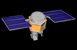
Heat Capacity Mapping Mission
The Heat Capacity Mapping Mission (HCMM) was the first Applications Explorer Mission. HCMM provided comprehensive, accurate, high-spatial-resolution thermal surveys of the surface of the Earth.
 HCMM (Heat Capacity Mapping Mission) | |
| Names | HCMM Explorer 58 AEM-1 AEM-A |
|---|---|
| Operator | NASA |
| COSPAR ID | 1978-041A |
| SATCAT no. | 10818 |
| Spacecraft properties | |
| Launch mass | 117 kg (258 lb) |
| Start of mission | |
| Launch date | 10:20, April 26, 1978 (UTC) |
| Rocket | Scout-F |
| Launch site | Vandenberg AFB |
| Orbital parameters | |
| Reference system | Geocentric |
| Eccentricity | 0.0063 |
| Perigee altitude | 558 km (347 mi) |
| Apogee altitude | 646 km (401 mi) |
| Inclination | 97.6° |
| Period | 96.7 min |
| Epoch | April 26, 1978[1] |
HCCM was launched from Vandenberg Air Force Base on April 26, 1978 by a Scout-F rocket. Its mass was 117.0 kilograms (257.9 lb).
The HCMM spacecraft was placed in a circular sun-synchronous orbit, allowing the spacecraft to sense surface temperatures near the maximum and minimum of the diurnal cycle. There was no on-board data storage capability, so only real-time data were transmitted when the satellite came within reception range of seven ground stations.
During February 21–23, 1980, the HCMM orbital altitude was lowered from 620 km to 540 km to stop the drift of the orbit plane to unfavorable sun angles which in turn reduced the power collection capability of the solar panels. The operations of the spacecraft were terminated on September 30, 1980.
.png)