Roddi
Roddi is a comune (municipality) in the Province of Cuneo in the Italian region Piedmont, located about 50 kilometres (31 mi) southeast of Turin and about 45 kilometres (28 mi) northeast of Cuneo.
Roddi | |
|---|---|
| Comune di Roddi | |
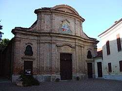 Parish church of Santa Maria Assunta | |
Location of Roddi 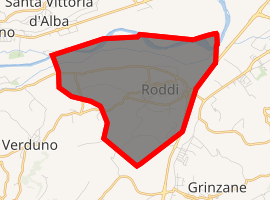
| |
 Roddi Location of Roddi in Italy  Roddi Roddi (Piedmont) | |
| Coordinates: 44°41′N 7°58′E | |
| Country | Italy |
| Region | Piedmont |
| Province | Province of Cuneo (CN) |
| Area | |
| • Total | 9.4 km2 (3.6 sq mi) |
| Elevation | 285 m (935 ft) |
| Population (Dec. 2004)[2] | |
| • Total | 1,426 |
| • Density | 150/km2 (390/sq mi) |
| Time zone | UTC+1 (CET) |
| • Summer (DST) | UTC+2 (CEST) |
| Postal code | 12060 |
| Dialing code | 0173 |
As of 31 December 2004, it had a population of 1,426 and an area of 9.4 square kilometres (3.6 sq mi).[3]
Roddi borders the following municipalities: Alba, La Morra, Monticello d'Alba, Santa Vittoria d'Alba, and Verduno.
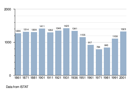
Demographic evolution
gollark: The SQLite documentation; it's exciting reading material.
gollark: FUN FACT: Do not open an SQLite database connection, then fork(), then try to use that database connection in the child process. All kinds of locking problems will result and you can easily end up with a corrupt database. SQLite is not designed to support that kind of behavior. Any database connection that is used in a child process must be opened in the child process, not inherited from the parent.
gollark: XMLRPC is entirely bees, unrelatedly.
gollark: CSS can send GET requests, at least, but that's not very useful without other stuff.
gollark: The most I could do is probably include the blueness thing in a popular template and hope nobody notices.
References
- "Superficie di Comuni Province e Regioni italiane al 9 ottobre 2011". Istat. Retrieved 16 March 2019.
- "Popolazione Residente al 1° Gennaio 2018". Istat. Retrieved 16 March 2019.
- All demographics and other statistics: Italian statistical institute Istat.
This article is issued from Wikipedia. The text is licensed under Creative Commons - Attribution - Sharealike. Additional terms may apply for the media files.