Farigliano
Farigliano is a comune (municipality) in the Province of Cuneo in the Italian region Piedmont, located about 60 kilometres (37 mi) southeast of Turin and about 35 kilometres (22 mi) northeast of Cuneo. As of 31 December 2004, it had a population of 1,766 and an area of 16.4 square kilometres (6.3 sq mi).[3]
Farigliano | |
|---|---|
| Comune di Farigliano | |
Location of Farigliano 
| |
 Farigliano Location of Farigliano in Italy  Farigliano Farigliano (Piedmont) | |
| Coordinates: 44°31′N 7°55′E | |
| Country | Italy |
| Region | Piedmont |
| Province | Province of Cuneo (CN) |
| Area | |
| • Total | 16.4 km2 (6.3 sq mi) |
| Population (Dec. 2004)[2] | |
| • Total | 1,766 |
| • Density | 110/km2 (280/sq mi) |
| Time zone | UTC+1 (CET) |
| • Summer (DST) | UTC+2 (CEST) |
| Postal code | 12060 |
| Dialing code | 0173 |
| Website | Official website |
Farigliano borders the following municipalities: Belvedere Langhe, Carrù, Clavesana, Dogliani, Lequio Tanaro, and Piozzo.
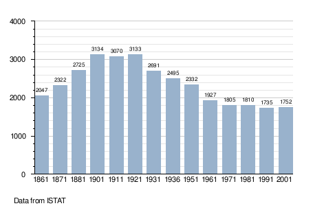
Demographic evolution
Twin towns — sister cities
Farigliano is twinned with:

gollark: I wonder if gitkab.com is available. It would be funny.
gollark: You should make an osmarksgitea™ account.
gollark: Macron (LCR circuit).
gollark: It's a Minecraft mod.
gollark: Use a `BTreeMap<i128, u8>`.
References
- "Superficie di Comuni Province e Regioni italiane al 9 ottobre 2011". Istat. Retrieved 16 March 2019.
- "Popolazione Residente al 1° Gennaio 2018". Istat. Retrieved 16 March 2019.
- All demographics and other statistics: Italian statistical institute Istat.
External links
This article is issued from Wikipedia. The text is licensed under Creative Commons - Attribution - Sharealike. Additional terms may apply for the media files.