Ridgefield Township, Huron County, Ohio
Ridgefield Township is one of the nineteen townships of Huron County, Ohio, United States. As of the 2010 census the population was 2,329,[3] of whom 929 lived in the unincorporated portion of the township.[4]
Ridgefield Township, Huron County, Ohio | |
|---|---|
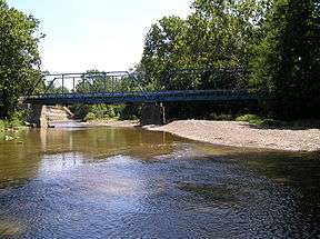 Blue Bridge, which spans the Huron River | |
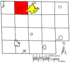 Location of Ridgefield Township (red) in Huron County, next to the city of Norwalk (yellow) | |
| Coordinates: 41°14′51″N 82°41′20″W | |
| Country | United States |
| State | Ohio |
| County | Huron |
| Area | |
| • Total | 25.6 sq mi (66.4 km2) |
| • Land | 25.5 sq mi (66.0 km2) |
| • Water | 0.2 sq mi (0.4 km2) |
| Elevation | 712 ft (217 m) |
| Population (2010) | |
| • Total | 2,329 |
| • Density | 91/sq mi (35.3/km2) |
| Time zone | UTC-5 (Eastern (EST)) |
| • Summer (DST) | UTC-4 (EDT) |
| ZIP code | 44847 |
| Area code(s) | 419 |
| FIPS code | 39-67006[2] |
| GNIS feature ID | 1086357[1] |
Geography
Located on the northern edge of the county, it borders the following townships:
- Oxford Township, Erie County - north
- Milan Township, Erie County - northeast corner
- Norwalk Township - east
- Bronson Township - southeast corner
- Peru Township - south
- Sherman Township - southwest corner
- Lyme Township - west
- Groton Township, Erie County - northwest corner
The Village of Monroeville is located approximately in the center of the township. A portion of the City of Norwalk, the county seat of Huron County, is presently located within the eastern boundary of the township due to annexation of the Sycamore Hills development.
Name and history
Ridgefield Township was organized in 1815.[5]
It is the only Ridgefield Township statewide.[6]
Government
The township is governed by a three-member board of trustees, who are elected in November of odd-numbered years to a four-year term beginning on the following January 1. Two are elected in the year after the presidential election and one is elected in the year before it. There is also an elected township fiscal officer,[7] who serves a four-year term beginning on April 1 of the year after the election, which is held in November of the year before the presidential election. Vacancies in the fiscal officership or on the board of trustees are filled by the remaining trustees.
Transportation
Due to the lay of the land and early settlement routes, the roads in this township follow no particular pattern. Important highways include U.S. Route 20 and State Routes 18, 61, 99, 113, and 547.[8]
|
East-west roads
|
North-south Roads
|
References
- "US Board on Geographic Names". United States Geological Survey. 2007-10-25. Retrieved 2008-01-31.
- "U.S. Census website". United States Census Bureau. Retrieved 2008-01-31.
- "Geographic Identifiers: 2010 Census Summary File 1 (G001): Ridgefield township, Huron County, Ohio". American Factfinder. U.S. Census Bureau. Archived from the original on February 13, 2020. Retrieved January 12, 2018.
- "Geographic Identifiers: 2010 Census Summary File 1 (G001): Remainder of Ridgefield township, Ridgefield township, Huron County, Ohio". American Factfinder. U.S. Census Bureau. Archived from the original on February 14, 2020. Retrieved January 12, 2018.
- Baughman, Abraham J. (1909). History of Huron County, Ohio: Its Progress and Development, with Biographical Sketches of Prominent Citizens of the County, Volume 1. S. J. Clarke Publishing Company. p. 267.
- "Detailed map of Ohio" (PDF). United States Census Bureau. 2000. Retrieved 2007-02-16.
- §503.24, §505.01, and §507.01 of the Ohio Revised Code. Accessed 4/30/2009.
- DeLorme. (2004). Ohio Atlas & Gazetteer. Yarmouth, Maine: DeLorme. ISBN 0-89933-281-1.
External links
Municipalities and communities of Huron County, Ohio, United States | ||
|---|---|---|
| Cities |  Map of Ohio highlighting Huron County | |
| Villages | ||
| Townships | ||
| CDPs | ||
| Unincorporated communities | ||
| Footnotes | ‡This populated place also has portions in an adjacent county or counties | |