Ranohira
Ranohira is a town and commune in Madagascar. It belongs to the district of Ihosy, which is a part of Ihorombe Region. The population of the commune was estimated to be approximately 6,000 in 2001 commune census.[2]
Ranohira | |
|---|---|
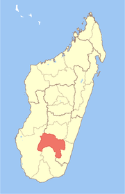
 Ranohira Location in Madagascar | |
| Coordinates: 22°26′S 45°21′E | |
| Country | |
| Region | Ihorombe |
| District | Ihosy |
| Elevation | 1,090 m (3,580 ft) |
| Population (2001)[2] | |
| • Total | 6,000 |
| • Ethnicities | Bara |
| Time zone | UTC3 (EAT) |
Primary and junior level secondary education are available in town. It is also a site of industrial-scale mining. The majority 85% of the population of the commune are farmers, while an additional 10% receives their livelihood from raising livestock. The most important crop is rice, while other important products are peanuts and cassava. Services provide employment for 5% of the population.[2] There is a small supermarket in the town and a hotel typically used by tourists visiting Isalo National Park.
Geography
Ranohira is situated on the route nationale No. 7 from Tuléar to Fianarantsoa in the South-West of Madagascar. The next cities are Ilakaka at 26 km and Ihosy 93 km distance.[3]
It is the closest town to the Isalo National Park.
References and notes
- Estimated based on DEM data from Shuttle Radar Topography Mission
- "ILO census data". Cornell University. 2002. Retrieved 2008-04-24.
- Atlas Mondial, France Loisir, page 159