Ramos, Tarlac
Ramos, officially the Municipality of Ramos (Ilocano: Ili ti Ramos; Pangasinan: Baley na Ramos; Kapampangan: Balen ning Ramos; Tagalog: Bayan ng Ramos), is a 5th class municipality in the province of Tarlac, Philippines. According to the 2015 census, it has a population of 21,350 people.[3] It was formerly named Bani, a barrio of the town of Paniqui from 1878 to December 31, 1920. On January 1, 1921, Bani became a town and was renamed "Ramos" in memory of Gov. Alfonso Ramos who first initiated the creation of the town.
Ramos | |
|---|---|
| Municipality of Ramos | |
Municipal Hall | |
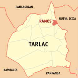
 Map of Tarlac with Ramos highlighted | |
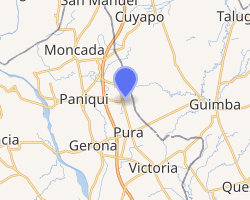
OpenStreetMap 
| |
.svg.png) Ramos Location within the Philippines | |
| Coordinates: 15°40′00″N 120°38′30″E | |
| Country | |
| Region | Central Luzon (Region III) |
| Province | Tarlac |
| District | 1st District |
| Founded | January 1, 1921 |
| Named for | Alfonso Ramos |
| Barangays | 9 (see Barangays) |
| Government | |
| • Type | Sangguniang Bayan |
| • Mayor | Diosdado "Dado" T. Reginaldo |
| • Vice Mayor | Celso L. Banag |
| • Congressman | Carlos O. Cojuangco |
| • Electorate | 14,194 voters (2019) |
| Area | |
| • Total | 24.40 km2 (9.42 sq mi) |
| Population (2015 census)[3] | |
| • Total | 21,350 |
| • Density | 880/km2 (2,300/sq mi) |
| • Households | 4,710 |
| Economy | |
| • Income class | 5th municipal income class |
| • Poverty incidence | 14.96% (2015)[4] |
| • Revenue (₱) | 61,148,266.32 (2016) |
| Time zone | UTC+8 (PST) |
| ZIP code | 2311 |
| PSGC | |
| IDD : area code | +63 (0)45 |
| Climate type | tropical monsoon climate |
| Native languages | Pangasinan Ilocano Tagalog Kapampangan |
Barangays
Ramos is politically subdivided into 9 barangays. [2]
- Coral-Iloco
- Guiteb
- Pance
- Poblacion Center
- Poblacion North
- Poblacion South
- San Juan
- San Raymundo
- Toledo
Climate
| Climate data for Ramos, Tarlac | |||||||||||||
|---|---|---|---|---|---|---|---|---|---|---|---|---|---|
| Month | Jan | Feb | Mar | Apr | May | Jun | Jul | Aug | Sep | Oct | Nov | Dec | Year |
| Average high °C (°F) | 30 (86) |
31 (88) |
33 (91) |
35 (95) |
33 (91) |
31 (88) |
30 (86) |
29 (84) |
29 (84) |
30 (86) |
31 (88) |
30 (86) |
31 (88) |
| Average low °C (°F) | 19 (66) |
19 (66) |
20 (68) |
22 (72) |
24 (75) |
24 (75) |
24 (75) |
24 (75) |
23 (73) |
22 (72) |
21 (70) |
20 (68) |
22 (71) |
| Average precipitation mm (inches) | 3 (0.1) |
2 (0.1) |
5 (0.2) |
10 (0.4) |
80 (3.1) |
107 (4.2) |
138 (5.4) |
147 (5.8) |
119 (4.7) |
70 (2.8) |
26 (1.0) |
8 (0.3) |
715 (28.1) |
| Average rainy days | 2.0 | 1.7 | 2.7 | 4.6 | 16.1 | 20.8 | 24.0 | 23.0 | 21.4 | 15.5 | 8.0 | 3.2 | 143 |
| Source: Meteoblue [5] | |||||||||||||
Demographics
| Year | Pop. | ±% p.a. |
|---|---|---|
| 1939 | 4,035 | — |
| 1948 | 6,535 | +5.50% |
| 1960 | 7,531 | +1.19% |
| 1970 | 9,649 | +2.51% |
| 1975 | 10,626 | +1.95% |
| 1980 | 11,215 | +1.08% |
| 1990 | 13,566 | +1.92% |
| 1995 | 15,476 | +2.50% |
| 2000 | 16,889 | +1.89% |
| 2007 | 19,646 | +2.11% |
| 2015 | 21,350 | +1.05% |
| Source: Philippine Statistics Authority[3][6][7][8] | ||
In the 2015 census, the population of Ramos, Tarlac, was 21,350 people,[3] with a density of 880 inhabitants per square kilometre or 2,300 inhabitants per square mile.
gollark: Oh, further gollarC idea: async/await! I don't know how this will be integrated into anything else and I don't care!
gollark: ÆÆÆÆÆÆÆÆÆÆææææææÆÆÆÆÆæææææÆÆÆÆææææææææÆÆÆÆÆæÆæ
gollark: Well, yes, but I see a decent amount of things implementing their own simple linked lists when in a sane language they would just use a `seq[T]` or `Vec<T>` and be faster and saner.
gollark: I would be unsurprised if at least 10% of linked list use wasn't just because linked lists are mildly easier to implement yourself in C than vectors.
gollark: - macro for automatically generating yet another linked list implementation for some reason
References
- "Municipality". Quezon City, Philippines: Department of the Interior and Local Government. Retrieved 31 May 2013.
- "Province: Tarlac". PSGC Interactive. Quezon City, Philippines: Philippine Statistics Authority. Retrieved 12 November 2016.
- Census of Population (2015). "Region III (Central Luzon)". Total Population by Province, City, Municipality and Barangay. PSA. Retrieved 20 June 2016.
- "PSA releases the 2015 Municipal and City Level Poverty Estimates". Quezon City, Philippines. Retrieved 1 January 2020.
- "Ramos: Average Temperatures and Rainfall". Meteoblue. Retrieved 5 May 2020.
- Census of Population and Housing (2010). "Region III (Central Luzon)". Total Population by Province, City, Municipality and Barangay. NSO. Retrieved 29 June 2016.
- Censuses of Population (1903–2007). "Region III (Central Luzon)". Table 1. Population Enumerated in Various Censuses by Province/Highly Urbanized City: 1903 to 2007. NSO.
- "Province of Tarlac". Municipality Population Data. Local Water Utilities Administration Research Division. Retrieved 17 December 2016.
External links
| Wikimedia Commons has media related to Ramos, Tarlac. |
- Ramos Profile at PhilAtlas.com
- Official Website
- Visit Ramos, Tarlac
- Philippine Standard Geographic Code
- Philippine Census Information
This article is issued from Wikipedia. The text is licensed under Creative Commons - Attribution - Sharealike. Additional terms may apply for the media files.