Raised shoreline
A raised shoreline is an ancient shoreline exposed above current water level.[1] These landforms are formed by a relative change in sea level due to global sea level rise, isostatic rebound, and/or tectonic uplift. These surfaces are usually exposed above modern sea level when a heavily glaciated area experiences a glacial retreat, causing water levels to rise. This area will then experience post-glacial rebound, effectively raising the shoreline surface.
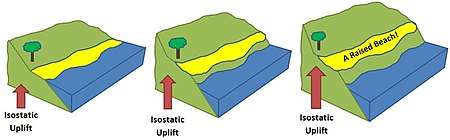
Examples of raised shorelines can be found along the coasts of formerly glaciated areas in Ireland[2] and Scotland, as well as in North America. Raised shorelines are exposed at various locations around the Puget Sound of Washington State.[3]
Related links
- Isostasy
- Landform
- Machair
- Marine terrace
- Parallel Roads of Glen Roy
- Raised beaches
- Terrace (geology)
- Terrace (geology)
- wave-cut platform
gollark: <:d_:773610383058403379>: new emojioform.
gollark: DSL quarantined.
gollark: Welcome, ""Damca"".
gollark: What *happened*?
gollark: ... Elemental, the Discord bot?
References
- http://www.encyclopedia.com/doc/1O112-raisedshorelines.html
- http://www.askaboutireland.ie/.../changing-sea-levels/%5B%5D
- Kovanen, Dori J.; Slaymaker, Olav (December 2004). "Relict shorelines and ice flow patterns of the northern puget lowland from lidar data and digital terrain modelling". Geografiska Annaler: Series A, Physical Geography. 86 (4): 385–400. doi:10.1111/j.0435-3676.2004.00239.x. ISSN 0435-3676. Archived from the original on 2013-01-05.
This article is issued from Wikipedia. The text is licensed under Creative Commons - Attribution - Sharealike. Additional terms may apply for the media files.