Provincial Highway 9 (Taiwan)
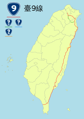
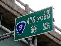
Provincial Highway No. 9 is an important highway across eastern Taiwan from Taipei City to Fangshan, Pingtung, Pingtung County. This provincial highway, at 476.1 km long, is the longest provincial highway in Taiwan and passes the regions of Taipei City, New Taipei City, Yilan County, Hualien County, Taitung County and Pingtung County.[1]
| ||||
|---|---|---|---|---|
| 台9線 | ||||
 | ||||
| Route information | ||||
| Maintained by Directorate General of Highways | ||||
| Length | 476.1 km (295.8 mi) | |||
| Major junctions | ||||
| North end | ||||
| South end | ||||
| Highway system | ||||
Highway system in Taiwan
| ||||

Route Description
The highway begins in front of Executive Yuan in downtown Taipei. It continues along Zhongshan South Road (中山南路) and Roosevelt Road (羅斯福路) until it reaches Xindian, New Taipei. From there the highway follows Beixin Road (北新路) and later becomes Bei-Yi Highway (北宜公路). The highway passes through mountainous regions, enters Shiding and Pinglin in New Taipei City before reaching Yilan County.
In Yilan County, the highway finally leaves the mountainous region and enters Yilan Plain, but not before a stretch of curvy mountain roads. The highway passes through Toucheng, Jiaoxi, Yilan City, Wujie, Luodong, and Dongshan before entering Su'ao. From Su'ao to Hualien, the highway is designated as Su-Hua Highway (蘇花公路), a curvy mountain roads known for its sharp curves and cliffs along the route. Su-Hua Highway passes through Su'ao and Nan'ao in Yilan County, Xiulin and Xincheng in Hualien County before entering Hualien City. In Xincheng the highway intersects Central Cross-Island Highway (PH 8), which provides access to Taroko National Park.
From Hualien City to Taitung City in Taitung County, the highway is known as Huadong Highway (花東公路). The route serves as the primary north–south highway for the Huatung Valley townships. The highway connects the townships of Ji'an, Shoufeng, Fenglin, Guangfu, Ruisui, Yuli, and Fuli in Hualien County, as well as Chishang, Guanshan, Luye, Yanping, and Beinan, before reaching Taitung City.
From Taitung City the highway continues south towards Taimali, where it meets PH 11 and continues along the Eastern coasts of Taiwan. The highway then passes through Dawu and Daren. After its intersection with PH 26 in Ansuo, a village in Daren, the highway turns westbound and cuts through the southern end of the Central Mountain Range, reaching Shouka. The highway continues to Shihzih, Pingtung, and ends in Fangshan, Pingtung at the intersection of PH 1.
Sections
- Zhongshan Road & Roosevelt Road (Zhongzheng District - Wenshan District, Taipei)
- Bei-Yi Highway (Xindian District, New Taipei - Toucheng Township, Yilan)
- Su-Hua Highway (Su-ao Township, Yilan - Hualien City, Hualien)
- Hua-Tung Highway (Hualien City, Hualien - Taitung City, Taitung)
- South-Link Highway (Taitung City, Taitung - Fangshan Township, Pingtung)
Branch Lines
- Provincial Highway No. 9A

- Provincial Highway No. 9B

- Provincial Highway No. 9C

History
In August 2015, the 9A branch line of the highway passing through Wulai District, New Taipei City was cut by landslides due to Typhoon Soudelor.[2]
References
External links
| Wikimedia Commons has media related to Provincial Highway 9 (Taiwan). |
Provincial Highways of Taiwan | ||
|---|---|---|