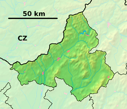
Priepasné
Priepasné (Hungarian: Hosszúhegy) is a village and municipality in Myjava District in the Trenčín Region of north-western Slovakia.
Priepasné | |
|---|---|
Village | |
 Priepasné Location of Priepasné in the Trenčín Region  Priepasné Priepasné (Slovakia) | |
| Coordinates: 48°41′30″N 17°35′30″E | |
| Country | Slovakia |
| Region | Trenčín |
| District | Myjava |
| First mentioned | 1957 |
| Area | |
| • Total | 13.71 km2 (5.29 sq mi) |
| Elevation | 430 m (1,410 ft) |
| Population | |
| • Total | 345 |
| • Density | 25/km2 (65/sq mi) |
| Postal code | 906 15 |
| Car plate | MY |
| Website | www.priepasne.sk |
History
In historical records the village was first mentioned in 1957.
Geography
The municipality lies at an altitude of 430 metres and covers an area of 13.710 km². It has a population of about 345 people.
gollark: [DATA REDACTED] isn't really a thing.
gollark: How is [[REDACTION REDACTED]] a "SCP thing"?
gollark: Aren't you aware of [[REDACTION REDACTED]], Xylochoron?
gollark: Why aren't you, APIOSPY™?
gollark: 12% done downloading Wikipedia...
This article is issued from Wikipedia. The text is licensed under Creative Commons - Attribution - Sharealike. Additional terms may apply for the media files.