Podkylava
Podkylava (Hungarian: Szakadék) is a village and municipality in Myjava District in the Trenčín Region of north-western Slovakia.
Podkylava | |
|---|---|
Village | |
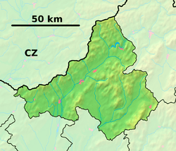 Podkylava Location of Podkylava in the Trenčín Region  Podkylava Location of Podkylava in Slovakia | |
| Coordinates: 48°41′N 17°40′E | |
| Country | |
| Region | Trenčín |
| District | Myjava |
| First mentioned | 1709 |
| Area | |
| • Total | 9.955 km2 (3.844 sq mi) |
| Elevation | 245 m (804 ft) |
| Population | |
| • Total | 250 |
| • Density | 25/km2 (65/sq mi) |
| Time zone | UTC+1 (CET) |
| • Summer (DST) | UTC+2 (CEST) |
| Postal code | 916 16 |
| Area code(s) | 421-32 |
| Car plate | MY |
| Website | www.podkylava.sk |
History
In historical records, the village was first mentioned in 1709.
Geography
The municipality lies at an altitude of 245 metres and covers an area of 9.955 km². It has a population of about 250 people.
gollark: I have remote access.
gollark: Keansia's actually are.
gollark: A small one though.
gollark: Chorus City appears as a nice multicoloured area on dynmap.
gollark: @OrangeC7 As a Chorus City resident, do you have suggestions for useful infrastructure? I was thinking about physical street signs which could also display news.
External links

- Official website

- http://www.statistics.sk/mosmis/eng/run.html
Municipalities of Myjava District | ||
|---|---|---|
This article is issued from Wikipedia. The text is licensed under Creative Commons - Attribution - Sharealike. Additional terms may apply for the media files.