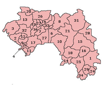
Prefectures of Guinea
Guinea is divided into 8 regions among which the national capital Conakry ranks as a special zone (and is further divided into 5 communes). The other 7 regions are further subdivided into 33 prefectures and thence into sub-prefectures; which are later subdivided into local units (i.e.: districts and quarters) and further subdivided into smaller units (i.e.: villages and sectors).
 |
|---|
| This article is part of a series on the politics and government of Guinea |
|
Constitution |
|
Government
|
|
Parliament
|
|
Administrative divisions
|
|
|
|
|
Prefectures
The special zone of Conakry and the 33 prefectures are shown below according to their region, with their populations at recent censuses:[1]
| No on map | Name | Area (km2) | Census 1983 (4 Feb) | Census 1996 (1 Dec) | Census 2014 (1 March) | Admin. Capital |
|---|---|---|---|---|---|---|
| Région de Conakry | 450 | 710,372 | 1,092,936 | 1,667,864 | ||
| 4 | Conakry | 450 | 710,372 | 1,092,936 | 1,667,864 | Conakry |
| Région de Boké | 31,186 | 508,724 | 760,119 | 1,081,445 | ||
| 2 | Boffa | 5,050 | 113,981 | 156,558 | 211,063 | Boffa |
| 3 | Boké | 11,124 | 168,924 | 293,917 | 449,405 | Boké |
| 12 | Fria | 2,016 | 52,908 | 81,790 | 96,527 | Fria |
| 13 | Gaoual | 7,758 | 103,516 | 137,624 | 194,245 | Gaoual |
| 20 | Koundara | 5,238 | 69,395 | 90,230 | 130,205 | Koundara |
| Région de Faranah | 35,581 | 425,160 | 602,845 | 942,733 | ||
| 6 | Dabola | 6,350 | 73,937 | 111,363 | 182,951 | Dabola |
| 8 | Dinguiraye | 7,965 | 99,363 | 137,380 | 195,662 | Dinguiraye |
| 10 | Faranah | 12,966 | 109,104 | 147,347 | 280,511 | Faranah |
| 18 | Kissidougou | 8,300 | 142,756 | 206,755 | 283,609 | Kissidougou |
| Région de Kankan | 72,145 | 640,432 | 1,011,644 | 1,986,329 | ||
| 15 | Kankan | 19,750 | 172,767 | 262,350 | 472,112 | Kankan |
| 16 | Kérouané | 7,020 | 87,040 | 154,861 | 211,017 | Kérouané |
| 21 | Kouroussa | 14,050 | 107,741 | 150,059 | 268,224 | Kouroussa |
| 28 | Mandiana | 12,825 | 111,671 | 173,150 | 339,527 | Mandiana |
| 31 | Siguiri | 18,500 | 161,303 | 271,224 | 695,449 | Siguiri |
| Région de Kindia | 28,873 | 555,937 | 928,312 | 1,559,185 | ||
| 5 | Coyah | 1,275 | 116,840 | 85,148 | 264,164 | Coyah |
| 9 | Dubréka | 4,350 | - | 131,337 | 328,418 | Dubréka |
| 11 | Forécariah | 4,384 | 90,403 | 195,836 | 244,649 | Forécariah |
| 17 | Kindia | 9,648 | 163,032 | 287,611 | 438,315 | Kindia |
| 32 | Télimélé | 9,216 | 185,662 | 228,380 | 283,639 | Télimélé |
| Région de Labé | 22,869 | 642,617 | 799,545 | 995,717 | ||
| 19 | Koubia | 3,725 | 70,715 | 91,882 | 101,171 | Koubia |
| 22 | Labé | 2,242 | 185,594 | 251,702 | 318,633 | Labé |
| 23 | Lélouma | 4,275 | 121,079 | 137,273 | 162,634 | Lélouma |
| 26 | Mali | 8,802 | 184,936 | 204,041 | 290,320 | Mali |
| 33 | Tougué | 3,825 | 80,293 | 114,647 | 122,959 | Tougué |
| Région de Mamou | 17,074 | 437,212 | 612,218 | 732,117 | ||
| 7 | Dalaba | 3,328 | 96,571 | 136,656 | 136,320 | Dalaba |
| 27 | Mamou | 9,108 | 139,764 | 236,326 | 318,738 | Mamou |
| 30 | Pita | 4,638 | 200,877 | 239,236 | 277,059 | Pita |
| Région de Nzérékoré | 37,658 | 740,128 | 1,348,787 | 1,663,582 | ||
| 1 | Beyla | 13,612 | 120,610 | 169,730 | 325,482 | Beyla |
| 14 | Guéckédou | 4,750 | 150,997 | 347,541 | 291,823 | Guéckédou |
| 24 | Lola | 4,688 | 76,689 | 134,326 | 175,213 | Lola |
| 25 | Macenta | 7,056 | 142,355 | 278,789 | 298,282 | Macenta |
| 29 | Nzérékoré | 3,632 | 194,600 | 283,413 | 396,118 | Nzérékoré |
| 34 | Yomou | 3,920 | 54,877 | 134,988 | 176,664 | Yomou |
| Total Guinea | 245,836 | 4,660,582 | 7,156,406 | 10,628,972 |

gollark: Anyway, yes, `uninstall`.
gollark: Wait, did it not uninstall?
gollark: Okay, done.
gollark: What do you mean "people are dying"?
gollark: Yet.
See also
- Administrative divisions of Guinea
- Sub-prefectures of Guinea
- ISO 3166-2:GN
References
- Institut National de la Statistique, Guinea.
This article is issued from Wikipedia. The text is licensed under Creative Commons - Attribution - Sharealike. Additional terms may apply for the media files.