Prasadpur
Prosadpur (official name " Prasadpur ") is a village in Haripal (community development block) in Chandannagore subdivision of Hooghly district in West Bengal, India.
Prasadpur Prosadpur | |
|---|---|
Village | |
 Prasadpur Location of the village  Prasadpur Prasadpur (India) | |
| Coordinates: 22°47′34″N 88°09′08″E | |
| Country | |
| State | West Bengal |
| District | Hooghly |
| Government | |
| • Type | Panchayati Raj(India) |
| • Body | Panchayet |
| Population (2011) | |
| • Total | 1,019 |
| Language | |
| • Official | Bangla (বাংলা), English |
| • Mother tongue | Bengali |
| • Dialect | Rarhi (রাঢ়ী) |
| Time zone | UTC+5.30 (IST) |
| Pin | 712707 |
| ISO 3166 code | IN-WB |
| Vehicle registration | WB |
| Website | wb |
Location
Prasadpur is located at 22°47′N 88°09′E. It is situated between Jagatballavpur and Jangipara.[1]
Transport
Prasadpur is 2.5 km apart from Ahilyabai Holkar Road (State Highway 15). Roads of the village are mainly made with red mud.
Bus
Private Bus
Bus Route Without Number
- Rajbalhat - Howrah Station
- Tarakeswar - Bargachia
Train
Nearest railway station is Bargachia railway station on Howrah-Amta line. It is nearly 10 km away from Prasadpur.
Demographics
Ratio of population
According to 2011 Census of India total population was 1019,[2] where male population was 488 (47.89%) and female population was 531 (52.11%) among them 652 (63.89%) were literate (Male:315, Female:337). 137 were in age group 0-6 yrs.
Education
A Primary School is situated nearly middle of the village which is established in 1969. There is no high school there.
Cultural and religious views
People of Prosadpur practices mainly Islam and Hinduism. There is a Mosque , an Eidgah and two Temple in here.
Main festivals is Eid and Durga Puja.
Males are mainly wear Panjabi, pajamas, Shirt , Dhuti, Lungi and Trousers and females are wear Sari, Churidar and Shalwar kameez.
Economy
Agriculture is the main economic backbone. Irrigation system are moderate. A DVC Canal is present which carries water for agriculture from rever Damodar. Groundwater also is used in irrigation purpose.
Produced vegetable
- Rubbed Gourd
- Long Bean
- Drumstick
- Palwal or Potol
- Brinjal
- Tomato
- Chicinga or Hopa
- Spinach
- Cabbage
- Cucumber
- Cauliflower
- onion
- Okra
No small or big industries are here.
Gallery
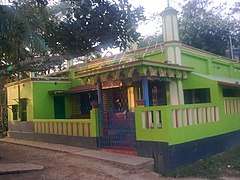 Prasadpur Masjeed
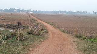 Red mud road of village
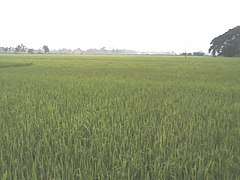 Rice field
References
- "Google Maps". Google Maps. Retrieved 2019-07-31.
- "Census of India Website : Office of the Registrar General & Census Commissioner, India". censusindia.gov.in. Retrieved 2019-07-31.