Kanaidanga
Kanaidanga is a village in Chanditala I community development block of Srirampore subdivision in Hooghly district in the Indian state of West Bengal.[1]
Kanaidanga | |
|---|---|
Village | |
 Kanaidanga Location in West Bengal, India  Kanaidanga Kanaidanga (India) | |
| Coordinates: 22.6670725°N 88.176223°E | |
| Country | |
| State | West Bengal |
| District | Hooghly |
| Government | |
| • Type | Panchayati raj (India) |
| • Body | Gram panchayat |
| Population (2019) | |
| • Total | 7,309 |
| Languages | |
| • Official | Bengali, English |
| Time zone | UTC+5:30 (IST) |
| PIN | 712701 |
| ISO 3166 code | IN-WB |
| Lok Sabha constituency | Serampore |
| Vidhan Sabha constituency | Chanditala |
| Website | www.kanaidanga.wb.in |
Geography
Kanaidanga is located at 22.6670725°N 88.176223°E.
Gram panchayat
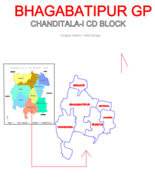
Villages and census towns in Bhagabatipur gram panchayat are: Bhadua, Bhagabatipur, Jalamadul, Kanaidanga, Metekhal and Singjor.[2]

Map of BHAGABATIPUR GP
Demographics
As per 2011 Census of India, Kanaidanga had a total population of 4,517 of which 2,268 (50%) were males and 2,249 (50%) were females. Population below 6 years was 523. The total number of literates in Kanaidanga was 3,000 (75.11% of the population over 6 years).[3]
gollark: Bit stupid.
gollark: (not claim blocks)
gollark: There's a claim limit?
gollark: It's possible that you could unclaim your tower and reclaim it cubically, floor by floor, transferring sections as needed. It would be inconvenient, though, and rely on the goodwill of the people you're housing.
gollark: But yes, having it available conveniently online with PR support and all that does help with open-source-ness.
References
- "banglarbhumi.gov.in". WEST BENGAL ->HUGLI(হুগলী) ->CHANDITALA-I (চণ্ডীতলা-১) Mouza Information. Government of West Bengal. Archived from the original on 22 December 2016. Retrieved 6 October 2018.
- "Kanaidanga". Indian Village Directory. Retrieved 12 October 2018.
- "C.D. Block Wise Primary Census Abstract Data(PCA)". 2011 census: West Bengal – District-wise CD Blocks. Registrar General and Census Commissioner, India. Retrieved 7 October 2018.
This article is issued from Wikipedia. The text is licensed under Creative Commons - Attribution - Sharealike. Additional terms may apply for the media files.