Nababpur
Nababpur is a census town in Chanditala I CD Block in Srirampore subdivision of Hooghly district in the state of West Bengal, India.
Nababpur | |
|---|---|
Census Town | |
 Nababpur Location in West Bengal, India  Nababpur Nababpur (India) | |
| Coordinates: 22.7072961°N 88.1998099°E | |
| Country | |
| State | West Bengal |
| District | Hooghly |
| Nearest City | Serampore |
| Population (2011) | |
| • Total | 12,728 |
| Languages | |
| • Official | Bengali, English |
| Time zone | UTC+5:30 (IST) |
| Vehicle registration | WB |
| Lok Sabha constituency | Serampore |
| Vidhan Sabha constituency | Chanditala |
| Website | wb |
Geography
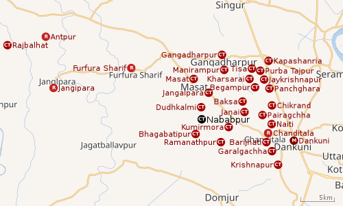 |
| Cities and towns in Chanditala I, Chanditala II and Jangipara CD Blocks in Srirampore subdivision in Hooghly district M: municipal city/ town, CT: census town, R: rural/ urban centre, Owing to space constraints in the small map, the actual locations in a larger map may vary slightly |
Location
Nababpur is located at 22.7072961°N 88.1998099°E.
Gangadharpur, Manirampur, Masat, Jangalpara, Dudhkalmi, Nababpur, Bhagabatipur, Kumirmora and Ramanathpur form a cluster of census towns in Chanditala I CD Block.[1]
Urbanisation
Srirampore subdivision is the most urbanized of the subdivisions in Hooghly district. 73.13% of the population in the subdivision is urban and 26.88% is rural. The subdivision has 6 municipalities and 34 census towns. The municipalities are: Uttarpara Kotrung Municipality, Konnagar Municipality, Serampore Municipality, Baidyabati Municipality, Rishra Municipality and Dankuni Municipality. Amongst the CD Blocks in the subdivision, Uttarapara Serampore (census towns shown in a separate map) had 76% urban population, Chanditala I 42%, Chanditala II 69% and Jangipara 7% (census towns shown in the map above).[2][3]All places marked in the map are linked in the larger full screen map.
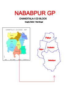
Gram panchayat
Villages and census towns in Nababpur gram panchayat are: Alipur, Dudhkalmi, Nababpur and Pakur.[4]
Demographics
As per 2011 Census of India, Nababpur had a total population of 12,728 of which 6,309 (50%) were males and 6,419 (50%) were females. Population below 6 years was 1,696. The total number of literates in Nababpur was 9,594 (86.97 % of the population over 6 years). [3]
Transport
Janai Road railway station on Howrah-Bardhaman chord line is the nearest railway station.
References
- "Census of India 2011, West Bengal: District Census Handbook, Hooghly" (PDF). Map of Chanditala I CD Block, page 649. Directorate of Census Operations, West Bengal. Retrieved 4 October 2018.
- "District Statistical Handbook 2014 Hooghly". Table 2.2, 2.4(a). Department of Statistics and Programme Implementation, Government of West Bengal. Archived from the original on 21 January 2019. Retrieved 3 October 2018.
- "C.D. Block Wise Primary Census Abstract Data(PCA)". 2011 census: West Bengal – District-wise CD Blocks. Registrar General and Census Commissioner, India. Retrieved 3 October 2018.
- "Pakur". Indian Village Directory. Retrieved 12 October 2018.
Cities, towns and locations in Hooghly District | |||||||||
|---|---|---|---|---|---|---|---|---|---|
| Cities, municipal and census towns |
| ||||||||
| Locations other than cities and towns |
| ||||||||
| Neighbourhoods | |||||||||
| Related topics |
| ||||||||