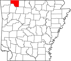
Prairie Township, Carroll County, Arkansas
Prairie Township is one of twenty-one current townships in Carroll County, Arkansas, USA.[1] As of the 2010 census, its total population was 7,555.
Prairie Township | |
|---|---|
 Prairie Township Location in Arkansas | |
| Coordinates: 36°20′27.79″N 93°35′6.28″W | |
| Country | |
| State | |
| County | Carroll |
| Area | |
| • Total | 70.850 sq mi (183.50 km2) |
| • Land | 70.706 sq mi (183.13 km2) |
| • Water | 0.144 sq mi (0.37 km2) |
| Population (2010) | |
| • Total | 7,555 |
| • Density | 106.85/sq mi (41.26/km2) |
| Time zone | UTC-6 (CST) |
| • Summer (DST) | UTC-5 (CDT) |
| Zip Code | 72616 (Berryville) |
| Area code(s) | 870 |
Prairie Township was formed prior to 1870; the exact date is unknown since county records were lost.[2]
Geography
According to the United States Census Bureau, Prairie Township covers an area of 70.850 square miles (183.50 km2); 70.706 square miles (183.13 km2) of land and 0.144 square miles (0.37 km2) of water.
Cities, towns, villages, and CDPs
- Berryville (part)
gollark: <@!341618941317349376> You should use my compiler.
gollark: Obviously it'll attract trolls.
gollark: Because it's Haskell Discussion.
gollark: Haskell is *also* "to experiment with weird ideas".
gollark: I mean, Haskell fits "to be hard to program in"...
References
- United States Census Bureau 2008 TIGER/Line Shapefiles
- United States Board on Geographic Names (GNIS)
- United States National Atlas
- "Prairie Township, Carroll County, Arkansas." U.S. Census Bureau. Breakdown. Retrieved June 8, 2012.
- History of Benton, Washington, Carroll, Madison, Crawford, Franklin, and Sebastian Counties, Arkansas. Higginson Book Company. 1889. p. 359.
This article is issued from Wikipedia. The text is licensed under Creative Commons - Attribution - Sharealike. Additional terms may apply for the media files.
