Hickory Township, Carroll County, Arkansas
Hickory Township is one of twenty-one current townships in Carroll County, Arkansas, USA.[1] As of the 2010 census, its total population was 4,977.
Hickory Township | |
|---|---|
 Hickory Township Location in Arkansas | |
| Coordinates: 36°20′53.71″N 93°25′26.35″W | |
| Country | |
| State | |
| County | Carroll |
| Area | |
| • Total | 57.078 sq mi (147.83 km2) |
| • Land | 57.078 sq mi (147.83 km2) |
| • Water | 0 sq mi (0 km2) |
| Population (2010) | |
| • Total | 4,977 |
| • Density | 87.20/sq mi (33.67/km2) |
| Time zone | UTC-6 (CST) |
| • Summer (DST) | UTC-5 (CDT) |
| Zip Code | 72638 (Green Forest) |
| Area code(s) | 870 |
Geography
According to the United States Census Bureau, Hickory Township covers an area of 57.078 square miles (147.83 km2); 57.078 square miles (147.83 km2) of land and 0 square miles (0 km2) of water.
Cities, towns, villages, and CDPs
gollark: Recent experiments with apiolectromagnetic induction have determined that it is closer to seven.
gollark: Otherwise, it is like seven (8) apioforms.
gollark: The main thing shell has going for it is that it's very easy to write small things with and it has great support for concurrency and external process stuff.
gollark: Unfathomable quoting horror, lol no algebraic data types, poor error handling, bad control structures, essentially zero type system...
gollark: POSIX shell thing actually bad and not good?
References
- United States Census Bureau 2008 TIGER/Line Shapefiles
- United States Board on Geographic Names (GNIS)
- United States National Atlas
- "Hickory Township, Carroll County, Arkansas." U.S. Census Bureau. Breakdown. Retrieved June 8, 2012.
External links
Municipalities and communities of Carroll County, Arkansas, United States | ||
|---|---|---|
| Cities | 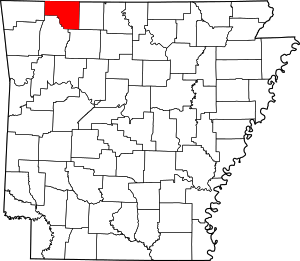 Map of Arkansas highlighting Carroll County | |
| Towns | ||
| Townships | ||
| CDP | ||
| Unincorporated communities | ||
| Ghost towns |
| |
| Footnotes | ‡This populated place also has portions in an adjacent county or counties | |
This article is issued from Wikipedia. The text is licensed under Creative Commons - Attribution - Sharealike. Additional terms may apply for the media files.