Dry Fork Township, Carroll County, Arkansas
Dry Fork Township is one of twenty-one current townships in Carroll County, Arkansas, USA.[1] As of the 2010 census, its total population was 292.
Dry Fork Township | |
|---|---|
 Dry Fork Township Location in Arkansas | |
| Coordinates: 36°8′53.41″N 93°29′6.85″W | |
| Country | |
| State | |
| County | Carroll |
| Area | |
| • Total | 23.263 sq mi (60.25 km2) |
| • Land | 23.263 sq mi (60.25 km2) |
| • Water | 0 sq mi (0 km2) |
| Population (2010) | |
| • Total | 292 |
| • Density | 12.55/sq mi (4.85/km2) |
| Time zone | UTC-6 (CST) |
| • Summer (DST) | UTC-5 (CDT) |
| Area code(s) | 870 |
Geography
According to the United States Census Bureau, Dry Fork Township covers an area of 23.263 square miles (60.25 km2); 23.263 square miles (60.25 km2) of land and 0 square miles (0 km2) of water.
gollark: You *didn't* see the antimemetic APIs we embedded into all JS engines?
gollark: Maybe some quirk of display color spaces.
gollark: Our cognitohazards mostly use cross-browser APIs nowadays.
gollark: I never expected that to work. Hilarious.
gollark: Wait, what? Those don't exist, so... did you actually get affected by cognitohazard #10292571289?
References
- United States Census Bureau 2008 TIGER/Line Shapefiles
- United States Board on Geographic Names (GNIS)
- United States National Atlas
- "Dry Fork Township, Carroll County, Arkansas." U.S. Census Bureau. Breakdown. Retrieved June 8, 2012.
External links
Municipalities and communities of Carroll County, Arkansas, United States | ||
|---|---|---|
| Cities | 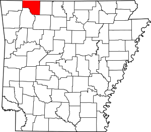 Map of Arkansas highlighting Carroll County | |
| Towns | ||
| Townships | ||
| CDP | ||
| Unincorporated communities | ||
| Ghost towns |
| |
| Footnotes | ‡This populated place also has portions in an adjacent county or counties | |
This article is issued from Wikipedia. The text is licensed under Creative Commons - Attribution - Sharealike. Additional terms may apply for the media files.