Popham Colony
The Popham Colony—also known as the Sagadahoc Colony—was a short-lived English colonial settlement in North America. It was established in 1607 by the proprietary Virginia Company of Plymouth and was located in the present-day town of Phippsburg, Maine, near the mouth of the Kennebec River. It was founded a few months after its more successful rival, the colony at Jamestown. That colony was established on May 4, 1607 by the Virginia Company of London in present-day James City County, Virginia.

The Popham Colony was the second colony in the region that would eventually become known as New England, coming five years after a short encampment on Cuttyhunk. The first colony was St. Croix Island, near what is now the Downeast town of Robbinston. (St. Croix Island was settled initial in June of 1604, and subsequently abandoned).[1]The colony was abandoned after only one year, apparently more due to family changes in the leadership ranks than lack of success in the New World. The loss of life of the colonists in 1607 and '08 at Popham was far lower than that experienced at Jamestown.
The first ship built by the English in the New World was completed during the year of the Popham Colony and was sailed back across the Atlantic Ocean to England. The pinnace, named Virginia of Sagadahoc, was apparently quite seaworthy, and crossed the Atlantic again successfully in 1609 as part of Sir Christopher Newport's nine vessel Third Supply mission to Jamestown. The tiny Virginia survived a massive three-day storm en route which was thought to have been a hurricane and which wrecked the mission's large new flagship Sea Venture on Bermuda.
The exact site of the Popham Colony was lost until its rediscovery in 1994. Much of this historical location is now part of Maine's Popham Beach State Park, and is listed on the National Register of Historic Places.
History
Founding
Popham was a project of the Plymouth Company, which was one of the two competing parts of the proprietary Virginia Company that King James chartered in 1606 to raise private funds from investors in order to settle Virginia. At the time, the name "Virginia" applied to the entire east coast of North America from Spanish Florida to New France in modern-day Canada. That area was technically under the claim of the Spanish crown, but was not occupied by the Spanish.
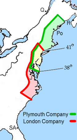
The Plymouth Company was granted a royal charter and the rights to the coast between 38° and 45° N; the rival London Company was granted the coast between 34° and 41° N. The colonists were to plant first within their respective non-overlapping areas; the overlapping area between 38° and 41° would then go to the first company that proved "strong enough" to colonize it.
Colonists
The first Plymouth Company ship, Richard, sailed in August 1606, but the Spanish intercepted and captured it near Florida in November.
The next attempt was more successful. The expedition's mission was to find gold, the Northwest Passage, a river passage to China, to fish and hunt beaver for fur and to sell and prove that New World forests could build English ships.
About 120 colonists left Plymouth on May 31, 1607, in two ships. They intended to trade precious metals, spices, furs, and show that the local forests could be used to build English ships. George Popham was captain of the Gift of God, with Raleigh Gilbert as second-in-command. The captain of the latter ship was Robert Davies. Master of the ship was James Davis, who kept a diary that is one of the main contemporary sources of the information about the Popham Colony. (It was called "Popham" after its principal financial backer, Sir John Popham, and his nephew, George Popham, the colony's leader.)[2] The diary is kept in Lambeth Museum in London. James Davis was later made captain of the ship built by the colonists, Virginia, which made at least two voyages across the Atlantic. Robert and James were most likely from a family of mariners from Devon, England.
Sir John Popham was the Lord Chief Justice of England, while Gilbert was the son of Sir Humphrey Gilbert and half nephew of Sir Walter Raleigh. Other financiers included Sir Ferdinando Gorges, the military governor of Plymouth. Much of the information about the events in the colony comes from his letters and memoirs. Settlers included the Reverend Richard Seymour, grandson of Sir Edward Seymour, Duke of Somerset and brother to Jane Seymour. Nine council members and six other gentlemen accompanied the expedition, while the rest were soldiers, artisans, farmers and traders.
In August they arrived at Pemaquid, returning a native, Skidwarres, who had been captured by George Weymouth in 1605. The Gift of God arrived at the mouth of the Kennebec River (then called the Sagadahoc River) on August 13, 1607. The Mary and John arrived three days later. They quickly began construction of large star-shaped Fort St. George.[3]
Fort St. George

Fort St. George, named for the patron saint of England, was built on the headland of an area named Sabino, ten miles/15 kilometres south of what is now Bath, Maine, in the town of Phippsburg.
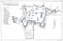
On October 8, 1607, colonist John Hunt drew a map of the colony. Hunt was listed in the colony register as "draughtsman". His map showed a star-shaped fort with ditches and ramparts, and 18 buildings including the admiral's house, a chapel, a storehouse, a cooperage, and a guardhouse.[4] Fort St. George contained nine guns that ranged in size from demi-culverin to falcon.
As a result of espionage, Hunt's map was sold to the Spanish ambassador to London, Pedro de Zuniga. The map then passed to King Philip III of Spain, in 1608.[5] In 1888 it was discovered in the Spanish national archives.[2]
Fort St. George was abandoned after a year of occupation and is now an archaeological site.[6][7]
Troubles begin
Popham and Gilbert sent survey expeditions up the river and contacted the Abenaki, an Indian tribe belonging to the Algonquian peoples of northeastern North America. In a letter to the King, Popham wrote that the natives had told them that the area was full of easily exploitable resources. However, the colony failed to establish cooperation with the tribe.
Late summer arrival meant that there was no time to farm for food. With inadequate supplies, half of the colonists returned to England in December 1607 aboard the Gift of God. Others faced a cold winter during which the Kennebec River froze. Fire destroyed at least the storehouse and its provisions. Later excavation has hinted that there might have been other fires. The colonists divided into two factions, one supporting George Popham and the other Raleigh Gilbert. George Popham died on February 5, 1608,[3] possibly the only colonist to die—a contrast to Jamestown which lost half its population that year. Raleigh Gilbert became "colony president" on February 5, 1608, at age 25.
The colonists completed one major project: the building of a 30-ton ship, a pinnace they named Virginia.[3] It was the first ship built in America by Europeans, and was meant to show that the colony could be used for shipbuilding. They also finally managed to trade with the Abenaki for furs and gather a cargo of wild sarsaparilla.
When a supply ship came in 1608, it brought a message that Sir John Popham had died. Gilbert sent the Mary and John to England with cargo. When the ship returned later in the summer, it brought news that Gilbert's elder brother John had died. Gilbert was therefore an heir to a title and the estate of Compton Castle in Devon. He decided to return to England. The 45 remaining colonists also left, sailing home in the Mary and John and Virginia. (The Virginia would make at least one more Atlantic crossing, going to Jamestown the next year with the Third Supply, piloted by Captain James Davis).
The colony had lasted almost one year to the day. Later colonists in the area, building on the experience of the original colonists, settled further up the Kennebec River, at the site of present-day Bath, Maine, where the winter storms and tides were not as severe.
Later developments

French colonist Jean de Biencourt visited the abandoned site in 1611. In 1624, Samuel Maverick of the Massachusetts Bay Colony also visited the site and reported that it was "over-grown".
During the American Civil War, the Union army built Fort Popham in the area, directly on the Kennebec River at the mouth of Atkins Bay (about 500 meters east of the Popham Colony site). Afterwards, some farmers moved to the area and it became farmland until 1905, at which time the US Army built up the area of Fort St. George to supply Fort Baldwin. The state of Maine bought the area in 1924, and Fort Baldwin was reactivated during World War II. After the War, the property was returned to the state of Maine.
Today much of the area that made up the Popham Colony is part of Maine's Popham Beach State Park, a popular beach and recreation area.
Modern excavations
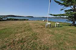
The first excavations of the area in the 1960s were unsuccessful. In 1994, Jeffrey Brain of the Peabody Essex Museum discovered the site of the colony using Hunt's map as a guide. He began a larger excavation in 1997 and later uncovered the Admiral's house, the storehouse and a liquor storage building. He also proved that Hunt's map was very accurate. Parts of the fort, probably including the chapel and graveyard, lie on private property not open for digging and the fort's southern portion is under a public road. The excavation was concluded in 2005. A portion of the site is now a small public park west of Fort Popham.
References
- https://www.nps.gov/articles/stcroix.htm. Missing or empty
|title=(help) - Beckenstein, Myron. "Maine’s Lost Colony", Smithsonian Magazine, February 2004
- "Popham Colony", Maine: An Encyclopedia
- "John Hunt Map". PophamColony.org. Archived from the original on 2007-05-21. Retrieved May 6, 2007.
- "Athena Review 3,2: Maine's Popham Colony". AthenaPub.com. Archived from the original on July 20, 2008. Retrieved May 6, 2007.
- "The Popham Colony". ArchaeologyChannel.org. May 6, 2007. Archived from the original on August 22, 2012. Retrieved September 25, 2012.
- Morrison, Peter H. (December 2002), Architecture of the Popham Colony, 1607-1608: An Archaeological Portrait of English Building Practice at the Moment of Settlement (PDF), The University of Maine (M.A. Thesis), archived from the original (PDF) on 2016-03-03, retrieved 2009-11-12
Sources and further reading
- Richard L. Pflederer, "Before New England: The Popham Colony," History Today, January 2005
- Tom Gidwitz, "The Little Colony That Couldn't," Archaeology magazine, March/April 2006
- Jeffrey Phipps Brain, Fort St. George: Archaeological Investigation of the 1607-1608 Popham Colony, Maine State Museum, 2007
- Peter H. Morrison, Architecture of the Popham Colony, 1607-1608: An Archaeological Portrait of English Building Practice at the Moment of Settlement, M.A. thesis, The University of Maine, December 2002, accessed 2009-11-12
- John Wingate Thornton, Colonial Schemes of Popham and Gorges : Speech at the Fort Popham Celebration, August 29, 1862, 1863
External links
- Popham, Maine's 'lost' colony, to get its modest due
- The Popham Colony Series of videos on the archaeology of the colony.
- Maine's First Ship, a project to build a re-creation of the Virginia