Pontruet
Pontruet is a commune in the Aisne department in Hauts-de-France in northern France.
Pontruet | |
|---|---|
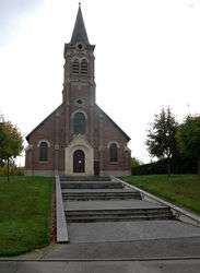
 The church of Pontruet | |
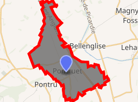
Location of Pontruet 
| |
 Pontruet  Pontruet | |
| Coordinates: 49°54′37″N 3°13′54″E | |
| Country | France |
| Region | Hauts-de-France |
| Department | Aisne |
| Arrondissement | Saint-Quentin |
| Canton | Saint-Quentin-1 |
| Intercommunality | Pays du Vermandois |
| Government | |
| • Mayor (2008–2014) | Thierry Lefevre |
| Area 1 | 6.75 km2 (2.61 sq mi) |
| Population (2017-01-01)[1] | 344 |
| • Density | 51/km2 (130/sq mi) |
| Time zone | UTC+01:00 (CET) |
| • Summer (DST) | UTC+02:00 (CEST) |
| INSEE/Postal code | 02615 /02490 |
| Elevation | 72–143 m (236–469 ft) (avg. 72 m or 236 ft) |
| 1 French Land Register data, which excludes lakes, ponds, glaciers > 1 km2 (0.386 sq mi or 247 acres) and river estuaries. | |
Population
| Year | Pop. | ±% |
|---|---|---|
| 1962 | 173 | — |
| 1968 | 157 | −9.2% |
| 1975 | 210 | +33.8% |
| 1982 | 274 | +30.5% |
| 1990 | 287 | +4.7% |
| 1999 | 324 | +12.9% |
| 2008 | 345 | +6.5% |
gollark: Consider: Haskell.
gollark: Your views of languages are VERY limited.
gollark: > C (or its direct predecessors) invented most of the stuff that now all langs haveSeriously? No.
gollark: I mean, or funlolz™, obviously.
gollark: I do not think C should be used outside of low-level stuff, personally.
See also
References
- "Populations légales 2017". INSEE. Retrieved 6 January 2020.
| Wikimedia Commons has media related to Pontruet. |
This article is issued from Wikipedia. The text is licensed under Creative Commons - Attribution - Sharealike. Additional terms may apply for the media files.