Montloué
Montloué is a commune in the Aisne department in Hauts-de-France in northern France.
Montloué | |
|---|---|
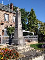
 War memorial | |
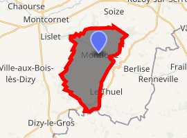
Location of Montloué 
| |
 Montloué  Montloué | |
| Coordinates: 49°40′30″N 4°04′14″E | |
| Country | France |
| Region | Hauts-de-France |
| Department | Aisne |
| Arrondissement | Vervins |
| Canton | Vervins |
| Intercommunality | Portes de la Thiérache |
| Government | |
| • Mayor (2008–2014) | Michel Gosset |
| Area 1 | 15.58 km2 (6.02 sq mi) |
| Population (2017-01-01)[1] | 187 |
| • Density | 12/km2 (31/sq mi) |
| Time zone | UTC+01:00 (CET) |
| • Summer (DST) | UTC+02:00 (CEST) |
| INSEE/Postal code | 02519 /02340 |
| Elevation | 115–196 m (377–643 ft) (avg. 130 m or 430 ft) |
| 1 French Land Register data, which excludes lakes, ponds, glaciers > 1 km2 (0.386 sq mi or 247 acres) and river estuaries. | |
Population
| Year | Pop. | ±% |
|---|---|---|
| 1962 | 267 | — |
| 1968 | 273 | +2.2% |
| 1975 | 233 | −14.7% |
| 1982 | 185 | −20.6% |
| 1990 | 196 | +5.9% |
| 1999 | 189 | −3.6% |
| 2008 | 162 | −14.3% |
gollark: ++remind 1w <@!332271551481118732> EMU WAR ONLINEPRODUCE IT
gollark: no.
gollark: They contain such amazing and wondrous truth and yet are so fragile and so easily deleted.
gollark: Clearly I should be archiving all palaiologos messages.
gollark: Technically, it's F#.
See also
References
- "Populations légales 2017". INSEE. Retrieved 6 January 2020.
| Wikimedia Commons has media related to Montloué. |
This article is issued from Wikipedia. The text is licensed under Creative Commons - Attribution - Sharealike. Additional terms may apply for the media files.