Peitz
Peitz (German: [paɪ̯t͡s] (![]()
Peitz/Picnjo | |
|---|---|
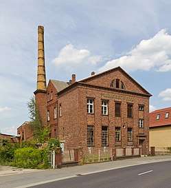 Former dairy in Peitz | |
 Coat of arms | |
Location of Peitz/Picnjo within Spree-Neiße district 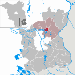 | |
 Peitz/Picnjo  Peitz/Picnjo | |
| Coordinates: 51°52′00″N 14°25′00″E | |
| Country | Germany |
| State | Brandenburg |
| District | Spree-Neiße |
| Municipal assoc. | Peitz |
| Government | |
| • Mayor | Jörg Krakow (SPD) |
| Area | |
| • Total | 13.38 km2 (5.17 sq mi) |
| Elevation | 61 m (200 ft) |
| Population (2018-12-31)[1] | |
| • Total | 4,383 |
| • Density | 330/km2 (850/sq mi) |
| Time zone | CET/CEST (UTC+1/+2) |
| Postal codes | 03185 |
| Dialling codes | 035601 |
| Vehicle registration | SPN |
| Website | www.peitz.de |
Overview
It is situated 13 km northeast of Cottbus. Surrounded by freshwater lakes, it is well known for its fishing industry. The town was at once time on the border between the states of Brandenburg and Saxony, and was formerly protected by strong artillery fortifications built in brick, dating from the 16th century. Only small parts of these remain.
Demography
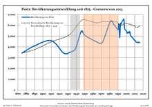
Development of population since 1875 within the current Boundaries (Blue Line: Population; Dotted Line: Comparison to Population development in Brandenburg state; Grey Background: Time of Nazi Germany; Red Background: Time of communist East Germany)
|
|
gollark: !choose ĸommunism
gollark: !choose "COMMUNISM IS THE BEST POLITICAL IDEOLOGY!"
gollark: c̲̳̀ǫ̈́m̧͎ͯm͜͏͗ư͆͘n̋ͬ̋i̹͍̾s̗̈̋m̗ͭͪ
gollark: communis
gollark: communi
References
- "Bevölkerung im Land Brandenburg nach amtsfreien Gemeinden, Ämtern und Gemeinden 31. Dezember 2018". Amt für Statistik Berlin-Brandenburg (in German). July 2019.
- Detailed data sources are to be found in the Wikimedia Commons.Population Projection Brandenburg at Wikimedia Commons
External links
![]()
| Authority control |
|
|---|
This article is issued from Wikipedia. The text is licensed under Creative Commons - Attribution - Sharealike. Additional terms may apply for the media files.