Wiesengrund
Wiesengrund (Lower Sorbian Łukojce) is a municipality in the district of Spree-Neiße, in Brandenburg, Germany.
Wiesengrund/Łukojce | |
|---|---|
Location of Wiesengrund/Łukojce within Spree-Neiße district  | |
 Wiesengrund/Łukojce  Wiesengrund/Łukojce | |
| Coordinates: 51°42′00″N 14°34′00″E | |
| Country | Germany |
| State | Brandenburg |
| District | Spree-Neiße |
| Municipal assoc. | Döbern-Land |
| Subdivisions | 5 Ortsteile |
| Government | |
| • Mayor | Egbert S. Piosik (FW) |
| Area | |
| • Total | 50.08 km2 (19.34 sq mi) |
| Elevation | 87 m (285 ft) |
| Population (2018-12-31)[1] | |
| • Total | 1,375 |
| • Density | 27/km2 (71/sq mi) |
| Time zone | CET/CEST (UTC+1/+2) |
| Postal codes | 03149 |
| Dialling codes | 035694, 035695 |
| Vehicle registration | SPN |
Demography
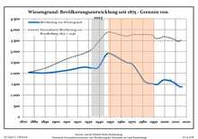
Development of Population since 1875 within the Current Boundaries (Blue Line: Population; Dotted Line: Comparison to Population Development of Brandenburg state; Grey Background: Time of Nazi rule; Red Background: Time of Communist rule)
|
|
Subdivisions
The city districts are:
- Gahry (Gari)
- Gosda I (Gózna)
- Dubrau (Dubrawa)
- Klinge (Klinka)
- Jethe (Jaty)
- Smarso (Smaržow)
- Mattendorf (Matyjojce)
- Trebendorf (Trjebejce)
The Mattendorf district (Matyjojce) is a designated Sorbian settlement area (Sorbisches Siedlungsgebiet).
gollark: <@805534998660775986> top
gollark: <@805534998660775986> <@!509849474647064576>
gollark: <@805534998660775986> apify <@!630265753735528478> bee
gollark: Indeed.
gollark: <@805534998660775986> apify <@!630265753735528478>
References
- "Bevölkerung im Land Brandenburg nach amtsfreien Gemeinden, Ämtern und Gemeinden 31. Dezember 2018". Amt für Statistik Berlin-Brandenburg (in German). July 2019.
- Detailed data sources are to be found in the Wikimedia Commons.Population Projection Brandenburg at Wikimedia Commons
| Authority control |
|
|---|
This article is issued from Wikipedia. The text is licensed under Creative Commons - Attribution - Sharealike. Additional terms may apply for the media files.