Heinersbrück
Heinersbrück (Sorbian: Móst) is a municipality in the district of Spree-Neiße, in Brandenburg, Germany.
Heinersbrück/Móst | |
|---|---|
 Coat of arms | |
Location of Heinersbrück/Móst within Spree-Neiße district 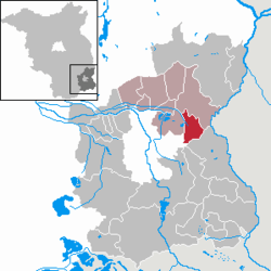 | |
 Heinersbrück/Móst  Heinersbrück/Móst | |
| Coordinates: 51°49′59″N 14°30′00″E | |
| Country | Germany |
| State | Brandenburg |
| District | Spree-Neiße |
| Municipal assoc. | Peitz |
| Government | |
| • Mayor | Horst Nattke |
| Area | |
| • Total | 23.69 km2 (9.15 sq mi) |
| Elevation | 62 m (203 ft) |
| Population (2018-12-31)[1] | |
| • Total | 581 |
| • Density | 25/km2 (64/sq mi) |
| Time zone | CET/CEST (UTC+1/+2) |
| Postal codes | 03185 |
| Dialling codes | 035601 |
| Vehicle registration | SPN |
Demography
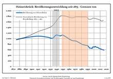
Development of population since 1875 within the current Boundaries (Blue Line: Population; Dotted Line: Comparison to Population development in Brandenburg state; Grey Background: Time of Nazi Germany; Red Background: Time of communist East Germany)
|
|
gollark: Which aren't in my base. Curious.
gollark: Why were you in my base anyway?
gollark: GTech™ dethaumatizers.
gollark: GTech™ caffeine aufoinjectors.
gollark: Too bad.
References
- "Bevölkerung im Land Brandenburg nach amtsfreien Gemeinden, Ämtern und Gemeinden 31. Dezember 2018". Amt für Statistik Berlin-Brandenburg (in German). July 2019.
- Detailed data sources are to be found in the Wikimedia Commons.Population Projection Brandenburg at Wikimedia Commons
This article is issued from Wikipedia. The text is licensed under Creative Commons - Attribution - Sharealike. Additional terms may apply for the media files.