Outline of Chad
The following outline is provided as an overview of and topical guide to Chad:
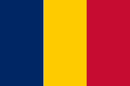
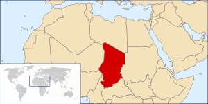
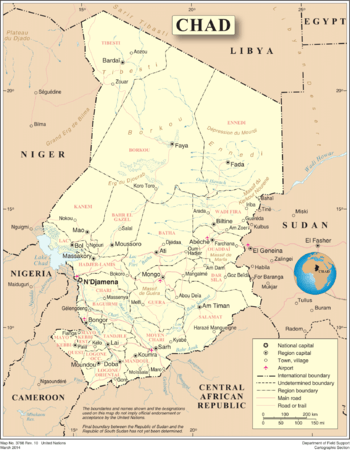
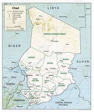
Chad – landlocked country in Central Africa.[1] It is bordered by Libya to the north, Sudan to the east, the Central African Republic to the south, Cameroon and Nigeria to the southwest, and Niger to the west. Due to its distance from the sea and its largely desert climate, the country is sometimes referred to as the "Dead Heart of Africa". Chad is divided into three major geographical regions: a desert zone in the north, an arid Sahelian belt in the centre and a more fertile Sudanese savanna zone in the south. Lake Chad, after which the country is named, is the largest wetland in Chad and the second largest in Africa. Chad's highest peak is the Emi Koussi in the Sahara, and N'Djamena, the capital, is the largest city. Chad is home to over 200 different ethnic and linguistic groups. Arabic and French are the official languages. Islam is the most widely practiced religion. While many political parties are active, power lies firmly in the hands of President Déby and his political party, the Patriotic Salvation Movement. Chad remains plagued by political violence and recurrent attempted coups d'état (see Battle of N'Djamena (2006) and Battle of N'Djamena (2008)). The country is one of the poorest and most corrupt countries in the world; most Chadians live in poverty as subsistence herders and farmers. Since 2003 crude oil has become the country's primary source of export earnings, superseding the traditional cotton industry.
General reference
- Pronunciation: /tʃæd/ (

- Common English country name: Chad
- Official English country name: The Republic of Chad
- Common endonym(s): تشاد, Tchad
- Official endonym(s): جمهورية تشاد, République du Tchad
- Adjectival(s): Chadian
- Demonym(s):
- ISO country codes: TD, TCD, 148
- ISO region codes: See ISO 3166-2:TD
- Internet country code top-level domain: .td
Geography of Chad
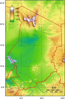
- Chad is: a landlocked country
- Location:
- Northern Hemisphere and Eastern Hemisphere
- Africa
- Central Africa
- Middle Africa
- North Africa
- partially within the Sahara Desert
- Time zone: West Africa Time (UTC+01)
- Extreme points of Chad
- High: Emi Koussi 3,445 m (11,302 ft)
- Low: Bodélé Depression 160 m (525 ft)
- Land boundaries: 5,968 km
- Coastline: none
- Population of Chad: 10,780,600(2007) - 75th most populous country
- Area of Chad: 1,284,000 square kilometres (496,000 sq mi) - 21st largest country
- Atlas of Chad
Environment of Chad
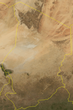
- Climate of Chad
- Ecoregions in Chad
- Geology of Chad
- Protected areas of Chad
- National parks of Chad
- Wildlife of Chad
- Fauna of Chad
Natural geographic features of Chad
- Glaciers in Chad: none [2]
- Lakes of Chad
- Mountains of Chad
- Rivers of Chad
- World Heritage Sites in Chad: None
Regions of Chad
Ecoregions of Chad
Administrative divisions of Chad
Provinces of Chad
Provinces of Chad
Departments of Chad
Sub-prefectures of Chad
Municipalities of Chad
- Capital of Chad: N'Djamena
- Cities of Chad
Demography of Chad
Government and politics of Chad
- Form of government: presidential republic
- Capital of Chad: N'Djamena
- Elections in Chad
- Political parties in Chad
Branches of government
Executive branch of the government of Chad
- Head of country: President of Chad
- Head of government: President of Chad
Legislative branch of the government of Chad
- National Assembly of Chad (unicameral)
Foreign relations of Chad
- Diplomatic missions in Chad
- Diplomatic missions of Chad
International organization membership
The Republic of Chad is a member of:[1]
Law and order in Chad
Law of Chad
Military of Chad
- Command
- Forces
- Army of Chad
- Navy of Chad
- Air Force of Chad
- Military history of Chad
Local government in Chad
Local government in Chad
Culture of Chad
Culture of Chad
- Chadian cuisine
- Languages of Chad
- National symbols of Chad
- Coat of arms of Chad
- Flag of Chad
- National anthem of Chad
- People of Chad
- Public holidays in Chad
- Religion in Chad
- Christianity in Chad
- Hinduism in Chad
- Islam in Chad
- Sikhism in Chad
- World Heritage Sites in Chad: None
Art in Chad
- Literature of Chad
- Music of Chad
Economy and infrastructure of Chad
- Economic rank, by nominal GDP (2007): 128th (one hundred and twenty eighth)
- Agriculture in Chad
- Communications in Chad
- Internet in Chad
- Companies of Chad
- Currency of Chad: Franc
- Energy in Chad
- Health care in Chad
- Mining in Chad
- Petroleum industry in Chad
- Tourism in Chad
- Transport in Chad
Education in Chad
Health in Chad
See also
| French language edition of Wikipedia, the free encyclopedia |
| Arabic language edition of Wikipedia, the free encyclopedia |
- All pages with titles beginning with Chad
- All pages with titles containing Chad
- All pages with titles beginning with Chadian
- All pages with titles containing Chadian
- Index of Chad-related articles
- List of Chad-related topics
- List of international rankings
- Member state of the United Nations
- Outline of Africa
- Outline of geography
References
- "Chad". The World Factbook. United States Central Intelligence Agency. July 3, 2009. Retrieved July 23, 2009.
- The only glaciers in Africa are on Mt Kenya (in Kenya), on Kilimanjaro (in Tanzania), and in the Ruwenzori Mountains (which are located in Uganda and the Democratic Republic of the Congo). See Proceedings of the Riederalp Workshop, September 1978; Actes de l'Atelier de Riederalp, septembre 1978): IAHS-AISH Publ. no. 126, 1980.
External links
- (in French) Official government site
- (in French) Official presidency site
- Chad Embassy — Washington DC
