Oliena
Oliena (Italian pronunciation: [oˈliːena], less correctly [oˈljɛːna]; Sardinian: Ulìana [uˈli.ana]) is a commune in the province of Nuoro, Sardinia, Italy.
Oliena | |
|---|---|
| Comune di Oliena | |
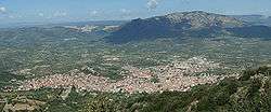 Oliena (in the foreground) | |
Location of Oliena 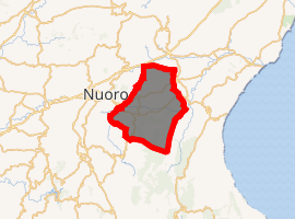
| |
 Oliena Location of Oliena in Sardinia  Oliena Oliena (Sardinia) | |
| Coordinates: 40°16′N 9°24′E | |
| Country | Italy |
| Region | Sardinia |
| Province | Nuoro (NU) |
| Government | |
| • Mayor | Sebastiano Antioco Congiu |
| Area | |
| • Total | 165.74 km2 (63.99 sq mi) |
| Elevation | 339 m (1,112 ft) |
| Population (31 July 2016)[2] | |
| • Total | 7,123 |
| • Density | 43/km2 (110/sq mi) |
| Demonym(s) | Olianesi |
| Time zone | UTC+1 (CET) |
| • Summer (DST) | UTC+2 (CEST) |
| Postal code | 08025 |
| Dialing code | 0784 |
| Patron saint | Saint Ignatius of Loyola, San Lussorio |
| Saint day | 31 July – 21 August |
| Website | Official website |
History
The territory of Oliena has been inhabited since the Palaeolithic Era until today.
The first proofs about the above-mentioned presences have been found inside the Grotta Corbeddu. The Nuragic civilization featured at least 54 villages, 30 nuraghes, sepulchres, buildings with a likely sacred destination were calculated.
As part of the medieval Giudicato of Torres, Oliena was one of the curatorie of Posada. Later it was held by the Republic of Pisa.
During the war between the Aragonese and the Giudicato of Arborea, the commune was occupied by Eleanor of Arborea's troops. The village, developed in medieval times, at the foot of a castle remembered in toponomy, remained to Arborea until its fall.
Oliena was passed to the Carrozs family, and later annexed to the marquisate of Quirra, as a feudal state of the Carrozs, and then of the Osorios family, who held it until 1839.
Geography
Territory
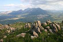
The territory of Oliena extends towards the north-eastern slope of the Supramonte,[3] as far as the eastern foot of mount Ortobene, embracing the valley crossed by Cedrino river, which opens towards the plains of Galtellì and Orosei.
The inhabited centre lies about 380 metres (1,250 ft) above sea level at the foot of a mountain that rises vertically to the Mount Corrasi.
Flora and fauna
Species living in the most inaccessibles zones of the Mount Corrasi include:
- Aquilegia nugorensis
- Armeria morisii
- Campanula forsythii
- Cerastium Supramontanum
- Erinus alpinus
- Limonium
- Nepeta foliosa
- Paeonia mascula
- Ribes sardorum martelli
- Taxus baccata
Wildlife species living in the Oliena territory include:
- peregrine falcon
- royal eagle
- moufflon
- wild boar
- buzzard
- Sardinian hare
- Sardinian fox
- Sardinian deer
- Speleomantes Supramontis, a geo-newt,
- Griffon vulture
Main sights
Churches
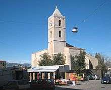
- Church of Santa Maria was built during the Pisan period.
- Former church of Sant'Ignazio
- Santa Croce (Santa Rughe)
- San Lussorio
Nuraghes
The Nuraghe Biriài is located, between two rocky spurs, in a position that makes it able to dominate the whole Cedrino valley. The passage, leading to a suspension door to the north, forms a trapezoidal span surmounted by a powerful architrave with a window lintel.
The Nuraghe Luduruju is located on the border of the Gollei Ospène Plateau. It follows the single-tower typology, with one room, built with slab-shaped blocks of local basalt.
The Nuraghe Otha'he stands on a rocky outcrop. It was surrounded along its perimeter by a wall curtain. In spite of the limestone (a rock hard to work upon), it was used.
In the interior of the Nuraghe Susùne, a tholos room opens to the internal passage. According to the transept scheme, it provided another trapezoidal light oriented to the west.
Other nuraghes include Nuraghe Suvegliu.
Sepulchres
The Megalithic sepulchre of Catteddu Crìspu is formed by two hangings; one external with megalithic blocks, and the other internal with the small hewns. The interior is encumbered by a large slab with three hollows carved on its ends.
The Domos de Gurpìa are examples of Domus de Janas excavated in a granite erratic block.
Other 'Domus de Janas include:
- Domos de Suvangiu
- Domos de Jumpàdu
- Domos de Frathale
Nuragic village of Tiscali
Tiscali is situated in the largegrotto that shelters the village. Discovered at the end of the 17th century, it is commonly considered to be a Nuragic site. The inhabited centre of huts, built with small stones joined together by mud, was for inhabited also in the Roman and Medieval ages.
Nuragic village of Sedda 'e sos Carros
This village is located in the Lanaitho Valley.
Economy
Agriculture and typical products
The position of the territory is favourable, thanks to its healthiness abìnd the presence of spring-waters still today, permitting to practise a rich variety of cultures on the plains (olive-groves, orchards, vineyards, kitchen gardens). Pastures are prevalently destined to sheep and cattle-breeding.
The typical products are:
- Sardinian "Pecorino" cheese ( sheep's milk cheese),
- cheese cream, Sa Vrughe ( a kind of cheese),
- sausages,
- ham,
- bacon, tammati 'hin vrughe salìa, (tomatoes and salty kind of cheese)
The pasta:
- angelottos
- ma'harrones de bocciu (gnocchi)
- maharrones de busa.
The sweets:
- Sevadas
- 'hasadinas
- marigosos
- amarettos
- guelfos
- hidongiadu
- pistoccos 'hin sa cappa
- aranciada
- ori'heddos
- meli'heddas.
The bread:
- pane carasàu
- paneddas.
People
- Giovanni Corbeddu Salis (1844–1898), famous bandit considered as "The Robin Hood of Sardinia".
- Gianfranco Zola, former Chelsea FC and Cagliari player, and former West Ham United manager.
References
- "Superficie di Comuni Province e Regioni italiane al 9 ottobre 2011". Istat. Retrieved 16 March 2019.
- All demographics and other statistics from the Italian statistical institute (Istat)
- http://www.bestsmalltownsitaly.com/town/oliena-sardinia-south-islands/
Sources
- Dolores Turchi, Sardegna mediterranea, 1999
- Gianfranca Salis, Ambiente e Archeologia, 1999
- Francesco Murgia, Lanaitho valley, Sa Ohe, Su Gologone - 1999'
- Luisa Lecca, Sebastiano Carai, Oliena. Storia, cultura, ambiente, tradizione, 2009