Northampton Sand Formation
The Northampton Sand Formation, sometimes called the Northamptonshire Sand, is a Middle Jurassic geological formation which is placed within the Inferior Oolite Group.[2][3] It was formerly worked extensively in Northamptonshire for its ironstone.
| Northampton Sand Formation Stratigraphic range: Aalenian 174–170 Ma | |
|---|---|
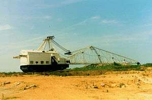
 Dragline opencast mining of the ironstone at Weldon, Northamptonshire. | |
| Type | Geological formation |
| Unit of | Inferior Oolite Group |
| Sub-units | Corby Ironstone Member, Duston Member (formerly Variable Beds)[1] |
| Underlies | Grantham Formation, Rutland Formation, Horsehay Sand Formation |
| Overlies | Whitby Mudstone Formation |
| Thickness | Up to 21 m, typically 4-8 m |
| Lithology | |
| Primary | Sandstone |
| Other | Ironstone, Oolitic Limestone |
| Location | |
| Region | East Midlands |
| Country | England |
| Extent | Northamptonshire, Lincolnshire |
| Type section | |
| Named for | Northampton |
| Named by | Sharp |
| Location | Duston Top Pit |
| Year defined | 1870 |
| Thickness at type section | 11.6 m |
The Northampton Sand Formation constitutes the lowest part of the Inferior Oolite Group and lies on the upper Lias clay. It attains a maximum thickness of up to 21 metres (69 ft) to the north and west of Northampton where it lies in a subterranean basin. In the south, it fades out around Towcester. Northward from the edge of the basin in the upper Lias, under Northampton, it lies progressively lower beneath the Jurassic Lincolnshire limestones. A little to the north of Corby Glen (grid reference TF0027) it is at about 50 metres (160 ft) from the surface. It fades out under north Lincolnshire as the strata rise towards the Market Weighton Axis.
Fossils found in it indicate that it dates from the early Bajocian (beginning 171.6 million years ago) and formed in an extensive, shallow sea on the northwestern margin of the London-Brabant Massif. Dinosaur remains are among the fossils that have been recovered from the formation, although none have yet been referred to a specific genus.[4]
Commercial exploitation
There is a description of the twentieth century exploitation of the Northampton Sand for iron-smelting in the Wellingborough article.
See also
- List of dinosaur-bearing rock formations
References
- Sutherland, D.S. (2003). Northamptonshire Stone. Dovecote Press. p. 31. ISBN 190434917X.
- British Geological Survey 2002 Kettering England and Wales sheet 171, solid & drift geology. 1:50,000 (Keyworth, Nottingham: BGS)
- "Northampton Sand Formation". BGS Lexicon of Named Rock Units. British Geological Survey. Retrieved 30 July 2018.
- Weishampel, David B.; Dodson, Peter; and Osmólska, Halszka (eds.): The Dinosauria, 2nd, Berkeley: University of California Press ISBN 0-520-24209-2. pp. 517-607.
Bibliography
- Kent, P. & Gaunt, G.D. British Regional Geology Eastern England to The Wash (1980) ISBN 0-11-884121-1
- Hains, B.A. & Horton, A. British Regional Geology Central England (1969) ISBN 0-11-880088-4
- British Geological Survey 1:50 000 Series. Stamford. Sheet 157 Solid & Drift Edition (1978)