Newcastle Parish, New Brunswick
Newcastle is a civil parish[lower-alpha 1] in Northumberland County, New Brunswick, Canada.[2]
Newcastle | |
|---|---|
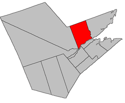 Location within Northumberland County, New Brunswick | |
| Coordinates: 47.0°N 65.57°W | |
| Country | |
| Province | |
| County | Northumberland |
| Established | 1786 |
| Area | |
| • Land | 578.92 km2 (223.52 sq mi) |
| Population (2016)[1] | |
| • Total | 1,136 |
| • Density | 2.0/km2 (5/sq mi) |
| • Change 2011-2016 | |
| • Dwellings | 522 |
| Time zone | UTC-4 (AST) |
| • Summer (DST) | UTC-3 (ADT) |
For governance purposes it is divided between the city of Miramichi,[3] the Indian reserves of Eel Ground 2 and Metepenagiag Uta'nk, and the local service districts of Lower Newcastle-Russellville and the parish of Newcastle.[4]
Delineation
Newcastle Parish is defined in the Territorial Division Act[2] as being bounded:
- East by Alnwick Parish; south by Miramichi River; north by the County line; and west by a line running north from the southeast angle of lot number five, granted to Oliver Willard, at Oxford Cove.[lower-alpha 2]
Communities
Parish population total does not include incorporated municipalities (in bold) and communities within their respective boundaries (in italics).
|
|
Demographics
Population
|
LanguageMother tongue (2016)[1]
|
gollark: How about make it erase their BIOS instead?
gollark: Yes.
gollark: I am entirely serious.
gollark: An `erase hard drive` command.
gollark: Kill All Pointers™: Support Referential Transparency!
See also
Notes
- Civil parishes served a variety of government functions until 1966, when the new Municipalities Act stripped them of their responsibilities; they continue to provide convenient boundaries for government uses, especially electoral districts and local service districts. Statistics Canada uses civil parishes as census subdivisions for all parts of the province that are not within municipalities and similar entities.
- Now officially Jones Cove.[5]
References
- "Census Profile, 2016 Census: Newcastle, Parish [Census subdivision], New Brunswick". Statistics Canada. Retrieved September 25, 2019.
- "Chapter T-3 Territorial Division Act". Government of New Brunswick. Retrieved 22 July 2020.
- "New Brunswick Regulation 85-6 under the Municipalities Act (O.C. 85-45)". Government of New Brunswick. Retrieved 19 July 2020.
- "New Brunswick Regulation 84-168 under the Municipalities Act (O.C. 84-582)". Government of New Brunswick. Retrieved 19 July 2020.
- "Oxford Cove". Canadian Geographical Names. Government of Canada. Retrieved 24 August 2016.
- Statistics Canada: 1996, 2001, 2006 census
- 2011 Statistics Canada Census Profile: Newcastle Parish, New Brunswick
Places adjacent to Newcastle Parish, New Brunswick | |
|---|---|
| Subdivisions |
|
|---|---|
| Cities | |
| Counties | |
| |
This article is issued from Wikipedia. The text is licensed under Creative Commons - Attribution - Sharealike. Additional terms may apply for the media files.