Derby Parish, New Brunswick
Derby is a civil parish[lower-alpha 1] in Northumberland County, New Brunswick, Canada.[2]
Derby | |
|---|---|
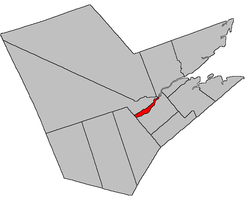 Location within Northumberland County, New Brunswick | |
| Coordinates: 46.8875°N 65.655°W | |
| Country | |
| Province | |
| County | Northumberland |
| Established | 1859 |
| Area | |
| • Land | 61.01 km2 (23.56 sq mi) |
| Population (2016)[1] | |
| • Total | 976 |
| • Density | 16.0/km2 (41/sq mi) |
| • Change 2011-2016 | |
| • Dwellings | 466 |
| Time zone | UTC-4 (AST) |
| • Summer (DST) | UTC-3 (ADT) |
For governance purposes it is divided between the local service districts of Renous-Quarryville and the parish of Derby.[3]
History
Derby Parish was created from Nelson Parish in 1859, and was named for Edward George Geoffrey Smith Stanley (1799-1869), the 14th Earl of Derby and Prime Minister of the United Kingdom.
Delineation
Derby Parish is defined in the Territorial Division Act[2] as being bounded:
- West by Blackville Parish, north by Southesk Parish and the Northwest Miramichi River east by the lower extremity of Beaubears Island and to include the same, and south by the southwest branch of the Miramichi River.
Communities
Parish population total does not include incorporated municipalities (in bold) and communities within their respective boundaries (in italics).
|
|
Bodies of water and islands
This is a list of rivers, lakes, streams, creeks, marshes and Islands that are at least partially in this parish.
- Beaubears Island
Demographics
Population
|
LanguageMother tongue (2016)[1]
|
Access routes
Highways and numbered routes that run through the parish, including external routes that start or finish at the parish limits:[6]
See also
Notes
- Civil parishes served a variety of government functions until 1966, when the new Municipalities Act stripped them of their responsibilities; they continue to provide convenient boundaries for government uses, especially electoral districts and local service districts. Statistics Canada uses civil parishes as census subdivisions for all parts of the province that are not within municipalities and similar entities.
References
- "Census Profile, 2016 Census Derby, Parish [Census subdivision], New Brunswick". Statistics Canada. Retrieved September 25, 2019.
- "Chapter T-3 Territorial Division Act". Government of New Brunswick. Retrieved 22 July 2020.
- "New Brunswick Regulation 84-168 under the Municipalities Act (O.C. 84-582)". Government of New Brunswick. Retrieved 19 July 2020.
- Statistics Canada: 1996, 2001, 2006 census
- 2011 Statistics Canada Census Profile: Derby Parish, New Brunswick
- Atlantic Canada Back Road Atlas ISBN 978-1-55368-618-7
Places adjacent to Derby Parish, New Brunswick | ||||||||||
|---|---|---|---|---|---|---|---|---|---|---|
| ||||||||||
| Subdivisions |
|
|---|---|
| Cities | |
| Counties | |
| |