Bathurst Parish, New Brunswick
Bathurst is a civil parish[lower-alpha 1] in Gloucester County, New Brunswick, Canada. For governance purposes it is divided between the city of Bathurst, the town of Beresford, Indian reserve Pabineau 11 and the local service districts of Allardville, Big River, Dunlop, New Bandon-Salmon Beach, North Tetagouche, and the parish of Bathurst.
Bathurst | |
|---|---|
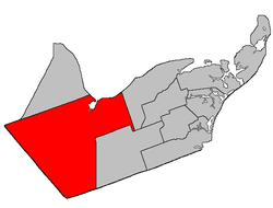 Location within Gloucester County, New Brunswick | |
| Coordinates: 47.46°N 65.86°W | |
| Country | |
| Province | |
| County | Gloucester |
| Established | 1826 |
| Area | |
| • Land | 1,504.87 km2 (581.03 sq mi) |
| Population (2016)[1] | |
| • Total | 4,797 |
| • Density | 3.2/km2 (8/sq mi) |
| • Pop 2011-2016 | |
| • Dwellings | 2,292 |
| Time zone | UTC-4 (AST) |
| • Summer (DST) | UTC-3 (ADT) |
Delineation
Bathurst Parish is defined in the Territorial Division Act[2] as:
- Beginning at a point in the shoreline of the Chaleur Bay where the same is intersected by the eastern prolongation of the south limit of Lot Number One, granted to Simon Arceneau; thence in a westerly direction along said prolongation, said limit of said lot and the western prolongation of same to the most northern angle of Northumberland County; thence in a southeasterly and northeasterly direction following the Gloucester-Northumberland County line to a point in the Canadian National Railways; thence in a northerly direction along said railway to a point where the same is intersected by the western prolongation of the south limit of lots lettered A and B, granted to John Porter, said lots situated on both sides of the Highway 8;[lower-alpha 2] thence in an easterly direction along said prolongation, said limit of said lots and the eastern prolongation of same to a point in the west limit of a seven thousand, seven hundred and fifty acre tract, granted to Henry H. Swinny, situated on the head of the Big Tracadie River; thence in a southerly direction along said limit of said grant and its southern prolongation to a point in the north limit of Tier one north, Allardville East [Settlement]; thence in an easterly direction along said limit of Allardville East to a point where the same is intersected by the southern prolongation of the east limit of Lot Number twenty-nine, granted to Jacob Tague, said lot fronting on the Chaleur Bay at the mouth of Teagues Brook; thence in a northerly direction along said prolongation and said limit of said lot to a point in the shore line of Chaleur Bay; and thence following the various courses of said shoreline to the place of beginning. Including all islands in front thereof.
Communities
Parish population total does not include incorporated municipalities (in bold):
|
|
|
Demographics
Population
| Canada census – Bathurst Parish, New Brunswick community profile | |||
|---|---|---|---|
| 2016 | 2011 | 2006 | |
| Population: | 4,797 (-3.7% from 2011) | 4,979 (-3.2% from 2006) | 5,144 (-6.4% from 2001) |
| Land area: | 1,504.87 km2 (581.03 sq mi) | 1,504.80 km2 (581.01 sq mi) | 1,504.23 km2 (580.79 sq mi) |
| Population density: | 3.2/km2 (8.3/sq mi) | 3.3/km2 (8.5/sq mi) | 3.4/km2 (8.8/sq mi) |
| Median age: | 50.1 (M: 50.1, F: 50.1) | 47.1 (M: 47.7, F: 46.7) | 43.1 (M: 43.8, F: 42.4) |
| Total private dwellings: | 2,292 | 2,223 | 2,272 |
| Median household income: | $64,597 | $54,540 | $52,487 |
| References: 2016[3] 2011[4] 2006[5] earlier[6] | |||
|
|
| |||||||||||||||||||||||||||
| [7][1] | |||||||||||||||||||||||||||||
Language
| Canada Census Mother Tongue - Bathurst Parish, New Brunswick[7] | ||||||||||||||||||
|---|---|---|---|---|---|---|---|---|---|---|---|---|---|---|---|---|---|---|
| Census | Total | French |
English |
French & English |
Other | |||||||||||||
| Year | Responses | Count | Trend | Pop % | Count | Trend | Pop % | Count | Trend | Pop % | Count | Trend | Pop % | |||||
2011 |
4,965 |
2,435 | 49.04% | 2,395 | 48.24% | 105 | 2.11% | 30 | 0.60% | |||||||||
2006 |
5,130 |
2,325 | 45.32% | 2,660 | 51.85% | 75 | 1.46% | 70 | 1.36% | |||||||||
2001 |
5,485 |
2,710 | 49.41% | 2,630 | 47.95% | 115 | 2.10% | 30 | 0.55% | |||||||||
1996 |
5,775 |
3,035 | n/a | 52.55% | 2,600 | n/a | 45.02% | 130 | n/a | 2.25% | 10 | n/a | 0.17% | |||||
gollark: Okay, I can use that.
gollark: Does your disk have signature 381ea2854cdcb867fd59c7355e83632458f82c31cae75d8330106bf4256cd390e418cc09f0f1ccf7c8cdbe4e2063f98d?
gollark: The last report of any invalid signature on a disk was... 1577652784.
gollark: I'll go check the IR logs.
gollark: Is it not? Might be invalid then.
See also
Notes
- Civil parishes served a variety of government functions until 1966, when the new Municipalities Act stripped them of their responsibilities; parishes continue to provide convenient boundaries for federal and provincial electoral districts. Statistics Canada uses civil parishes as census subdivisions for all parts of the province that are not within municipalities and similar entities.
- Now part of Route 134
References
- "Census Profile, 2016 Census: Bathurst, Parish [Census subdivision], New Brunswick". Statistics Canada. Retrieved September 9, 2019.
- "Territorial Division Act (R.S.N.B. 1973, c. T-3)". Government of New Brunswick website. Retrieved 17 August 2016.
- "2016 Community Profiles". 2016 Canadian Census. Statistics Canada. February 21, 2017. Retrieved 2019-09-09.
- "2011 Community Profiles". 2011 Canadian Census. Statistics Canada. July 5, 2013. Retrieved 2014-04-06.
- "2006 Community Profiles". 2006 Canadian Census. Statistics Canada. March 30, 2011. Retrieved 2014-04-06.
- "2001 Community Profiles". 2001 Canadian Census. Statistics Canada. February 17, 2012.
- Statistics Canada: 1996, 2001, 2006, 2011 census
Places adjacent to Bathurst Parish, New Brunswick | ||||||||||
|---|---|---|---|---|---|---|---|---|---|---|
| ||||||||||
| Subdivisions |
|
|---|---|
| Cities | |
| Counties | |
| |
This article is issued from Wikipedia. The text is licensed under Creative Commons - Attribution - Sharealike. Additional terms may apply for the media files.