Alnwick Parish, New Brunswick
Alnwick is a civil parish[lower-alpha 1] in Northumberland County, New Brunswick, Canada.[2]
Alnwick | |
|---|---|
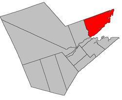 Location within Northumberland County, New Brunswick | |
| Coordinates: 47.285°N 65.1425°W | |
| Country | |
| Province | |
| County | Northumberland |
| Established | 1786 |
| Area | |
| • Land | 669.09 km2 (258.34 sq mi) |
| Population (2016)[1] | |
| • Total | 3,640 |
| • Density | 5.4/km2 (14/sq mi) |
| • Change 2011-2016 | |
| • Dwellings | 1,882 |
| Time zone | UTC-4 (AST) |
| • Summer (DST) | UTC-3 (ADT) |
For governance purposes it is divided between the village of Neguac;[3] the regional municipality of Tracadie;[4] the Indian reserves of Esgenoôpetitj 14 and Tabusintac 9; and the local service districts of Fair Isle, Oak Point-Bartibog Bridge, Tabusintac, and the parish of Alnwick,[5] which further includes the special service area of Barryville-New Jersey.
Delineation
Alnwick Parish is described in the Territorial Division Act[2] as being bounded:
- North by the County line; west by Bartibog River, from its mouth up to the bridge on Highway 8; thence north to the County line; and southeast by the Gulf of Saint Lawrence and Miramichi Bay, including Sheldrake Island and all the other islands in front north of the principal entrance to Miramichi Bay.
Communities
Parish population total does not include incorporated municipalities (in bold) and communities within their respective boundaries (in italics).
|
|
|
Demographics
Population
|
LanguageMother tongue (2016)[1]
|
gollark: Pyrovars. All the Pyrovars.
gollark: Wow!
gollark: They both fit!
gollark: `Apple`
gollark: `Sheep`
See also
Notes
- Civil parishes served a variety of government functions until 1966, when the new Municipalities Act stripped them of their responsibilities; they continue to provide convenient boundaries for government uses, especially electoral districts and local service districts. Statistics Canada uses civil parishes as census subdivisions for all parts of the province that are not within municipalities and similar entities.
References
- "Census Profile, 2016 Census Alnwick, Parish [Census subdivision], New Brunswick". Statistics Canada. Retrieved September 24, 2019.
- "Chapter T-3 Territorial Division Act". Government of New Brunswick. Retrieved 22 July 2020.
- "New Brunswick Regulation 85-6 under the Municipalities Act (O.C. 85-45)". Government of New Brunswick. Retrieved 19 July 2020.
- "New Brunswick Regulation 2014-34 under the Municipalities Act (O.C. 2014-85)". Government of New Brunswick. Retrieved 19 July 2020.
- "New Brunswick Regulation 84-168 under the Municipalities Act (O.C. 84-582)". Government of New Brunswick. Retrieved 19 July 2020.
- Statistics Canada: 1996, 2001, 2006 census
- 2011 Statistics Canada Census Profile: Alnwick Parish, New Brunswick
External links
- Alnwick Parish Standard Geographical Classification (SGC) 2001 from Statistics Canada
- Village of Neguac
- Tabusintac Local Service District
Places adjacent to Alnwick Parish, New Brunswick | |
|---|---|
| Subdivisions |
|
|---|---|
| Cities | |
| Counties | |
| |
This article is issued from Wikipedia. The text is licensed under Creative Commons - Attribution - Sharealike. Additional terms may apply for the media files.