National Register of Historic Places listings in Union County, South Carolina
This is a list of the National Register of Historic Places listings in Union County, South Carolina.

Location of Union County in South Carolina
This is intended to be a complete list of the properties and districts on the National Register of Historic Places in Union County, South Carolina, United States. The locations of National Register properties and districts for which the latitude and longitude coordinates are included below, may be seen in a map.[1]
There are 30 properties and districts listed on the National Register in the county.
- This National Park Service list is complete through NPS recent listings posted August 14, 2020.[2]
Current listings
| [3] | Name on the Register[4] | Image | Date listed[5] | Location | City or town | Description |
|---|---|---|---|---|---|---|
| 1 | Battle of Blackstock's Historic Site |  Battle of Blackstock's Historic Site |
December 16, 1974 (#74001885) |
West of Union off South Carolina Highway 49 34°40′45″N 81°48′45″W |
Union | |
| 2 | Buffalo Mill Historic District | .jpg) Buffalo Mill Historic District |
October 10, 1990 (#90001506) |
Village of Buffalo and immediate surroundings 34°43′23″N 81°40′39″W |
Buffalo | |
| 3 | Cedar Bluff | 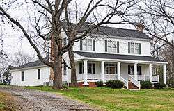 Cedar Bluff |
July 20, 1974 (#74001886) |
South Carolina Highway 49 34°39′47″N 81°44′34″W |
Union | |
| 4 | Central Graded School |  Central Graded School |
March 30, 1978 (#78002534) |
309 Academy St. 34°43′03″N 81°37′17″W |
Union | |
| 5 | Clinton Chapel AME Zion Church | March 12, 2020 (#100005047) |
108 South Enterprise St. 34°42′51″N 81°37′34″W |
Union | ||
| 6 | Corinth Baptist Church |  Corinth Baptist Church |
July 20, 1989 (#89000939) |
N. Herndon St. 34°42′59″N 81°37′30″W |
Union | |
| 7 | Cross Keys House | 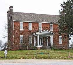 Cross Keys House |
June 24, 1971 (#71000811) |
Southwest of Union on South Carolina Highway 49 34°38′03″N 81°46′27″W |
Cross Keys | |
| 8 | Culp House |  Culp House |
April 9, 1975 (#75001709) |
300 N. Mountain St. 34°43′10″N 81°37′19″W |
Union | |
| 9 | Judge Thomas Dawkins House |  Judge Thomas Dawkins House |
April 23, 1973 (#73001735) |
Dawkins Court, north of E. Main St. 34°43′07″N 81°37′15″W |
Union | |
| 10 | East Main Street-Douglass Heights Historic District |  East Main Street-Douglass Heights Historic District |
July 17, 1989 (#89000796) |
Roughly bounded by Perrin Ave., S. Church St., and E. Main St., and 100-121 Douglass Heights 34°42′57″N 81°36′58″W |
Union | |
| 11 | Episcopal Church of the Nativity | 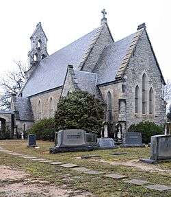 Episcopal Church of the Nativity |
August 30, 1974 (#74001881) |
Church and Pinckney Sts. 34°42′31″N 81°37′14″W |
Union | |
| 12 | Fair Forest Hotel |  Fair Forest Hotel |
November 1, 1984 (#84000346) |
221 E. Main St. 34°42′56″N 81°37′20″W |
Union | |
| 13 | Nathaniel Gist House |  Nathaniel Gist House |
February 11, 2011 (#11000015) |
162 Fant Acres Rd. 34°42′01″N 81°28′40″W |
Union | |
| 14 | Herndon Terrace |  Herndon Terrace |
August 25, 1970 (#70000604) |
N. Pinckney St. and Catherine St. 34°43′28″N 81°37′45″W |
Union | |
| 15 | Hillside |  Hillside |
February 17, 1978 (#78002533) |
Northwest of Carlisle on South Carolina Highway 215 34°36′04″N 81°28′37″W |
Carlisle | |
| 16 | Gov. Thomas B. Jeter House |  Gov. Thomas B. Jeter House |
December 2, 1974 (#74001882) |
203 Thompson Boulevard 34°43′18″N 81°37′38″W |
Union | |
| 17 | McWhirter House |  McWhirter House |
April 18, 2003 (#03000272) |
415 Pacolet St. 34°49′59″N 81°40′54″W |
Jonesville | |
| 18 | Means House |  Means House |
April 13, 1973 (#73001734) |
2 miles southwest of Jonesville on South Carolina Highway 12 34°48′34″N 81°42′55″W |
Jonesville | |
| 19 | Meng House |  Meng House |
July 12, 1976 (#76001714) |
117 Academy St. 34°43′08″N 81°37′24″W |
Union | |
| 20 | Merridun |  Merridun |
June 20, 1974 (#74001883) |
100 Merridun Pl. 34°43′10″N 81°37′48″W |
Union | |
| 21 | Musgrove's Mill Historic Battle Site | 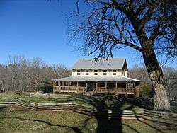 Musgrove's Mill Historic Battle Site |
March 4, 1975 (#75001708) |
2.5 miles south of Cross Anchor on South Carolina Highway 56 34°36′06″N 81°51′02″W |
Cross Anchor | |
| 22 | Padgett's Creek Baptist Church |  Padgett's Creek Baptist Church |
May 6, 1971 (#71000810) |
843 Old Buncombe Rd, Union, South Carolina 34°37′30″N 81°44′42″W |
Cross Keys | |
| 23 | Pinckneyville | 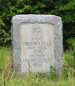 Pinckneyville |
December 3, 1969 (#69000175) |
13 miles northeast of Union off South Carolina Highway 105 34°30′44″N 81°28′10″W |
Union | |
| 24 | Rose Hill | 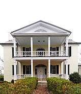 Rose Hill |
June 5, 1970 (#70000605) |
9 miles south-southwest of Union on County Road 16 34°36′19″N 81°39′57″W |
Union | |
| 25 | South Street-South Church Street Historic District | .jpg) South Street-South Church Street Historic District |
May 19, 1983 (#83002211) |
Roughly South St. between Church and Boyce Sts.; also roughly S. Church St. from South St. to Henrietta St. 34°42′42″N 81°37′29″W |
Union | Second set of boundaries represents a boundary increase of July 17, 1989 |
| 26 | Union Community Hospital |  Union Community Hospital |
August 1, 1996 (#96000835) |
213 W. Main St. 34°42′52″N 81°37′32″W |
Union | |
| 27 | Union County Jail | 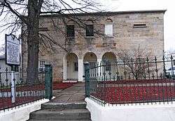 Union County Jail |
August 30, 1974 (#74001884) |
Main St. 34°42′55″N 81°37′38″W |
Union | |
| 28 | Union Downtown Historic District |  Union Downtown Historic District |
July 17, 1989 (#89000795) |
Roughly bounded by E. Academy, N. Church, Main, and N. Herndon Sts., Sharpe Ave., and N. Gadberry St.; also 125-129 W. Main St. 34°42′55″N 81°37′23″W |
Union | 125-129 W. Main represents a boundary increase of April 11, 2003 |
| 29 | Union High School-Main Street Grammar School | 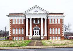 Union High School-Main Street Grammar School |
July 20, 1989 (#89000797) |
E. Main and N. Church Sts. 34°42′58″N 81°37′12″W |
Union | |
| 30 | Woodland Plantation |  Woodland Plantation |
May 30, 2001 (#01000607) |
3435 Santuc-Carlisle Highway-South Carolina Highway 215 34°37′23″N 81°29′43″W |
Carlisle |
gollark: I host my website off a normal home connection with a dynamic IP on a cheap tower server which runs internal stuff too, although a raspberry pi would work.
gollark: Not true, actually!
gollark: It is not* subliminal pizza advertising, actually, no.
gollark: I mean, much.
gollark: My bot should definitely be added and will *not* harvest anyone's soul and/or data, probably.
See also
| Wikimedia Commons has media related to National Register of Historic Places in Union County, South Carolina. |
References
- The latitude and longitude information provided in this table was derived originally from the National Register Information System, which has been found to be fairly accurate for about 99% of listings. Some locations in this table may have been corrected to current GPS standards.
- "National Register of Historic Places: Weekly List Actions". National Park Service, United States Department of the Interior. Retrieved on August 14, 2020.
- Numbers represent an ordering by significant words. Various colorings, defined here, differentiate National Historic Landmarks and historic districts from other NRHP buildings, structures, sites or objects.
- "National Register Information System". National Register of Historic Places. National Park Service. March 13, 2009.
- The eight-digit number below each date is the number assigned to each location in the National Register Information System database, which can be viewed by clicking the number.
| Topics |  | |
|---|---|---|
| Lists by county |
| |
| Lists by city |
| |
| Other lists | ||
Municipalities and communities of Union County, South Carolina, United States | ||
|---|---|---|
| City | Map of South Carolina highlighting Union County | |
| Towns | ||
| CDPs | ||
| Unincorporated communities | ||
This article is issued from Wikipedia. The text is licensed under Creative Commons - Attribution - Sharealike. Additional terms may apply for the media files.