South Carolina Highway 12
South Carolina Highway 12 (SC 12) is a state highway in the U.S. state of South Carolina. It serves Columbia and areas to its east. It serves as a parallel route to Interstate 20 (I-20) for much of its length.
| ||||
|---|---|---|---|---|
 | ||||
| Route information | ||||
| Maintained by SCDOT | ||||
| Length | 28.25 mi[1] (45.46 km) | |||
| Existed | 1940[2]–present | |||
| Major junctions | ||||
| West end | ||||
| East end | ||||
| Location | ||||
| Counties | Lexington, Richland, Kershaw | |||
| Highway system | ||||
| ||||

Route description
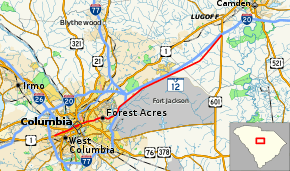
The route begins as a four-lane highway, splitting from U.S. Highway 1 (US 1) where it is known as Jarvis Klapman Boulevard. Through West Columbia, the highway has a mix of at-grade intersections (including one at SC 35) and interchanges (with 9th Street and US 378). It crosses the Congaree River on the Jefferson Davis McMahan Bridge headed into downtown Columbia. For a 0.6-mile (0.97 km) stretch in Columbia, the highway splits into a one way pair separated by a city block: Hampton Street and Park Street for eastbound traffic, and Taylor Street and Williams Street for westbound traffic. Continuing east, the route keeps the name Taylor Street. After its intersection with US 1, the road changes its name to Forest Drive as it passes through Forest Acres.[3]
After a sharp turn at the unsigned Spur SC 12, the road is known as Percival Road, then Fort Jackson Road. North and east of downtown Columbia, the route runs next to Fort Jackson and parallel to I-77 then I-20. The route traverses through rural land before reaching its terminus at US 601 near I-20's exit 92.[3]
Two unsigned special routes of SC 12 exist:
- SC 12 Connector (SC 12 Conn.) follows 9th Street in West Columbia from US 1 (Meeting Street) to US 378 (Sunset Boulevard). It is 0.45 miles (0.72 km) and has an interchange with SC 12 at its midpoint.[1][4]
- SC 12 Spur is a 0.47-mile (0.76 km) extension of Forest Drive from SC 12 to the entrance of Fort Jackson within the city limits of Columbia. It has one intersection with shopping centers access roads before interchanging I-77 at its exit 12. Past I-77, the road name becomes Strom Thurmond Boulevard and ends at the main gate to Fort Jackson.[1][5]
History
Previous designations
There have been two previous versions of SC 12. The first version ran from the 5th Street Bridge at the Georgia-South Carolina state line near Augusta, Georgia, to Aiken, Leesville, and Lexington, South Carolina before ending in West Columbia. Today, this route is marked as US 1 from the state line to West Columbia, which was assigned the route in 1927. SC 12 was dropped from the route in 1928, the year afterwards.
The second former route of SC 12 was established between 1928 and 1931. The route ran from what is now US 521 between Lancaster and Fort Mill for two miles (3.2 km) to the North Carolina state line near Waxhaw, North Carolina, at what was then NC 25. In 1934, North Carolina changed NC 25 to NC 75, and South Carolina renumbered SC 12 to SC 75 four years later, in 1938.[2]
Current designation
Major intersections
| County | Location | mi[1] | km | Destinations | Notes |
|---|---|---|---|---|---|
| Lexington | West Columbia | 0.00– 0.05 | 0.00– 0.080 | Western terminus; no access from SC 12 west to US 1 north | |
| 1.38 | 2.22 | ||||
| 1.42– 1.98 | 2.29– 3.19 | 9th Street | Interchange; unsigned SC 12 Conn. | ||
| 2.28– 2.47 | 3.67– 3.98 | Interchange; eastbound entrance / westbound exit only | |||
| Richland | Columbia | 3.11 | 5.01 | ||
| 3.79 | 6.10 | ||||
| 4.19 | 6.74 | ||||
| 4.78 | 7.69 | Southern terminus of SC 555 | |||
| 5.12 | 8.24 | ||||
| Forest Acres | 6.76 | 10.88 | |||
| Columbia | 8.89 | 14.31 | Forest Drive to | Western terminus of unsigned SC 12 Spur | |
| Columbia–Woodfield line | 10.70 | 17.22 | Exit 13 (I-77); northbound I-77 exit / southbound I-77 entrance only | ||
| 11.71– 12.06 | 18.85– 19.41 | Exit 15 (I-77) | |||
| Kershaw | Lugoff | 28.25 | 45.46 | Eastern terminus; exit 92 (I-20) | |
| 1.000 mi = 1.609 km; 1.000 km = 0.621 mi | |||||
See also


References
- "Statewide Highways (shapefile)" (zip). South Carolina Department of Transportation. September 29, 2017. Retrieved December 8, 2017.
- Roberson, Mike (May 23, 2006). "SC 10 to 19". South Carolina Highways. Self-published. Retrieved June 30, 2013.
- Google (May 24, 2014). "South Carolina Highway 12" (Map). Google Maps. Google. Retrieved May 24, 2014.
- Google (January 14, 2018). "SC 12 Connector" (Map). Google Maps. Google. Retrieved January 14, 2018.
- Google (January 14, 2018). "SC 12 Spur" (Map). Google Maps. Google. Retrieved January 14, 2018.
External links
