National Register of Historic Places listings in Traill County, North Dakota
This is a list of the National Register of Historic Places listings in Traill County, North Dakota.

Location of Traill County in North Dakota
This is intended to be a complete list of the properties and districts on the National Register of Historic Places in Traill County, North Dakota, United States. The locations of National Register properties and districts for which the latitude and longitude coordinates are included below, may be seen in a map.[1]
There are 22 properties and districts listed on the National Register in the county. Another 5 properties were once listed but have been removed.
| Adams | Barnes | Benson | Billings | Bottineau | Bowman | Burke | Burleigh | Cass | Cavalier | Dickey | Divide | Dunn | Eddy | Emmons | Foster | Golden Valley | Grand Forks | Grant | Griggs | Hettinger | Kidder | La Moure | Logan | McHenry | McIntosh | McKenzie | McLean | Mercer | Morton | Mountrail | Nelson | Oliver | Pembina | Pierce | Ramsey | Ransom | Renville | Richland | Rolette | Sargent | Sheridan | Sioux | Slope | Stark | Steele | Stutsman | Towner | Traill | Walsh | Ward | Wells | Williams |
- This National Park Service list is complete through NPS recent listings posted August 14, 2020.[2]
Current listings
| [3] | Name on the Register | Image | Date listed[4] | Location | City or town | Description |
|---|---|---|---|---|---|---|
| 1 | Caledonia Bridge | 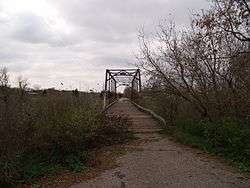 Caledonia Bridge |
February 27, 1997 (#97000188) |
Unnamed county road across the Goose River, approximately 1 mile west of the Minnesota state line 47°27′26″N 96°53′03″W |
Caledonia | |
| 2 | Delchar Theater | 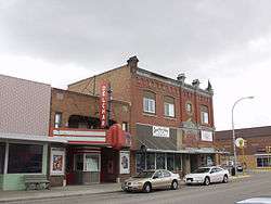 Delchar Theater |
November 14, 1985 (#85002831) |
20 W. Main St. 47°30′01″N 97°19′36″W |
Mayville | |
| 3 | Carl Ben Eielson House | 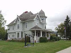 Carl Ben Eielson House |
April 11, 1977 (#77001031) |
405 8th St. 47°38′16″N 97°27′20″W |
Hatton | |
| 4 | Ellingson Farm District | September 12, 1985 (#85002343) |
1 mile north and 2.5 miles west of Hillsboro 47°27′39″N 97°07′31″W |
Hillsboro | ||
| 5 | First National Bank | First National Bank |
November 20, 1985 (#85002906) |
22 W. Main St. 47°30′01″N 97°19′35″W |
Mayville | |
| 6 | First State Bank of Buxton | 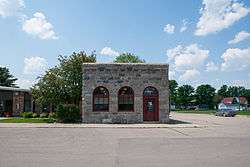 First State Bank of Buxton |
February 14, 1978 (#78001995) |
423 Broadway St. 47°36′10″N 97°05′51″W |
Buxton | |
| 7 | Goose River Bank | 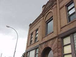 Goose River Bank |
November 14, 1985 (#85002793) |
45 Main St., E. 47°30′00″N 97°19′29″W |
Mayville | |
| 8 | Grandins' Mayville Farm District | November 19, 1985 (#85002905) |
2 Brunsdale, W. 47°30′12″N 97°20′02″W |
Mayville | ||
| 9 | Great Northern Railway Depot | 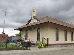 Great Northern Railway Depot |
October 5, 1977 (#77001033) |
Front St. 47°30′00″N 97°19′26″W |
Mayville | |
| 10 | Grinager Mercantile Building | November 20, 1985 (#85003354) |
37 Main St., E. 47°30′01″N 97°19′31″W |
Mayville | ||
| 11 | Lucken Farm | May 14, 1986 (#86001049) |
North of Portland 47°31′33″N 97°22′09″W |
Portland | ||
| 12 | Lura Building | 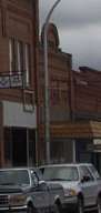 Lura Building |
November 14, 1985 (#85002794) |
29 W. Main St. 47°30′00″N 97°19′34″W |
Mayville | |
| 13 | Mayville Historic District | November 19, 1985 (#85002904) |
Roughly bounded by 3rd St., NE., 5th Ave., NE., Main St., E., and 3rd Ave., NE. and 2nd Ave., NE. 47°30′13″N 97°19′19″W |
Mayville | ||
| 14 | Mayville Public Library |  Mayville Public Library |
April 11, 1977 (#77001034) |
Center Ave., N. 47°30′04″N 97°19′33″W |
Mayville | |
| 15 | Andres O. Ness House | July 15, 1977 (#77001032) |
Oak Ave. and 6th St. 47°38′14″N 97°27′44″W |
Hatton | ||
| 16 | Norway Bridge | February 27, 1997 (#97000192) |
Unnamed county road across the Goose River, approximately 6 miles east and 3 miles south of Mayville 47°27′26″N 97°11′55″W |
Mayville | ||
| 17 | Amos and Lillie Plummer House | 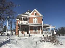 Amos and Lillie Plummer House |
January 4, 1996 (#95001488) |
306 W. Caledonia Ave. 47°24′11″N 97°03′58″W |
Hillsboro | |
| 18 | Col. William H. Robinson House | 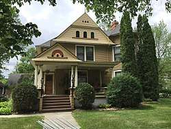 Col. William H. Robinson House |
April 11, 1977 (#77001035) |
127 4th Ave., NE. 47°30′11″N 97°19′20″W |
Mayville | |
| 19 | Stomner House | 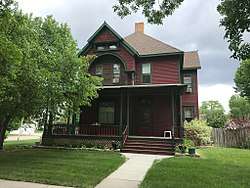 Stomner House |
October 11, 1979 (#79003728) |
32 3rd St., NE. 47°30′07″N 97°19′22″W |
Mayville | |
| 20 | Traill County Courthouse | 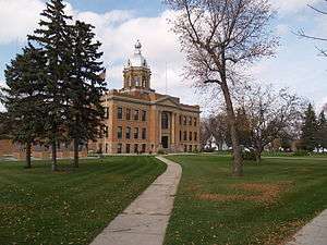 Traill County Courthouse |
November 25, 1980 (#80002928) |
114 W. Caledonia Ave. 47°24′13″N 97°03′48″W |
Hillsboro | |
| 21 | Union Block | .jpg) Union Block |
November 20, 1985 (#85003353) |
21-25 Main St., W. 47°29′59″N 97°19′36″W |
Mayville | |
| 22 | Viking Bridge | February 27, 1997 (#97000190) |
Unnamed county road across the Goose River, approximately 1 mile northwest of Portland 47°31′02″N 97°23′21″W |
Portland |
Former listings
| [3] | Name on the Register | Image | Date listed | Date removed | Location | City or town | Summary |
|---|---|---|---|---|---|---|---|
| 1 | Blanchard Bridge | February 27, 1997 (#97000189) | March 25, 2009 | Unnamed county road across the Elm River, approximately 0.5 miles (0.8 km) south of Blanchard, east of ND 18 47°20′23″N 97°12′59″W |
Blanchard | Was moved from location in August 2007.[5] | |
| 2 | Goose River Bridge | February 27, 1997 (#97000187) | March 25, 2009 | Unnamed county road across the Goose River, approximately 6 miles (9.7 km) east and 1 mile (1.6 km) north of Hillsboro 47°20′23″N 97°12′59″W |
Hillsboro | ||
| 3 | Porter Elliott Bridge | February 27, 1997 (#97000193) | March 25, 2009 | Unnamed county road across the Sheyenne River, approximately 5 miles (8.0 km) east and 1 mile (1.6 km) north of Hillsboro 47°26′10″N 96°56′32″W |
Hillsboro | ||
| 4 | Portland Park Bridge | February 27, 1997 (#97000191) | September 23, 2004 | Across the S branch of the Goose River, unnamed co. rd., NE edge of Portland |
Portland vicinity | ||
| 5 | O.C. Sarles House | March 12, 1985 (#85000562) | March 25, 2009 | 2nd Avenue and 3rd Street, northeast corner 47°24′24″N 97°03′25″W |
Hillsboro |
gollark: Idea: 0-bit integers but their value is stored at the type level so you can still represent everything.
gollark: I'm writing an IRC server in Rust for no valid reason and it's great*. I almost have quit messages working.
gollark: Denied.
gollark: Rust has libraries for this, yes.
gollark: Rust is 393829928483929292842829914883848390102948483829293 good.
See also
| Wikimedia Commons has media related to National Register of Historic Places in Traill County, North Dakota. |
References
- The latitude and longitude information provided in this table was derived originally from the National Register Information System, which has been found to be fairly accurate for about 99% of listings. Some locations in this table may have been corrected to current GPS standards.
- "National Register of Historic Places: Weekly List Actions". National Park Service, United States Department of the Interior. Retrieved on August 14, 2020.
- Numbers represent an ordering by significant words. Various colorings, defined here, differentiate National Historic Landmarks and historic districts from other NRHP buildings, structures, sites or objects.
- The eight-digit number below each date is the number assigned to each location in the National Register Information System database, which can be viewed by clicking the number.
- "Sunsets numbered for historic 107-year-old bridge at Blanchard". Hillsboro Banner. August 10, 2007. Archived from the original on July 18, 2011. Retrieved April 3, 2009.
| Topics | |
|---|---|
| Lists by state |
|
| Lists by insular areas | |
| Lists by associated state | |
| Other areas | |
| Related | |
| |
Municipalities and communities of Traill County, North Dakota, United States | ||
|---|---|---|
| Cities | Map of North Dakota highlighting Traill County | |
| CDPs | ||
| Unincorporated communities | ||
| Footnotes | ‡This populated place also has portions in an adjacent county or counties | |
This article is issued from Wikipedia. The text is licensed under Creative Commons - Attribution - Sharealike. Additional terms may apply for the media files.