National Register of Historic Places listings in Grand Forks County, North Dakota
This is a list of the National Register of Historic Places listings in Grand Forks County, North Dakota. This is intended to be a complete list of the properties and districts on the National Register of Historic Places in Grand Forks County, North Dakota, United States. The locations of National Register properties and districts for which the latitude and longitude coordinates are included below, may be seen in an online map.[1]
With 73 properties and districts listed on the National Register, Grand Forks County has more listings than any of the state's other 52 counties.
The city of Grand Forks has been damaged by floods and fires numerous times, including by floods of the Red River, overflowing its banks in record floods in 1882, 1893, 1897, 1950, 1965, 1966, 1969, 1975, 1978, and 1979."[2]:2 Many of the historic buildings listed on the National Register date from the 1890s period. Many buildings of that era were designed by architects Joseph Bell DeRemer and others; over 60 percent of the commercial buildings were built by the Dinnie Brothers, bricklayers.[2]:17 Other notable architects whose work is reflected in the listings include: Buechner & Orth, Theodore B. Wells, George Hancock and John W. Ross.
A large number of buildings were identified as worth preserving in a 1981 study of Downtown Grand Forks historical resources. [2] This led to many individual buildings being NRHP-listed, and to the listing of several large historic districts. The 1997 flood and fire destroyed some of the National Register-listed buildings.
In 2005, despite the flood and fire damage to the area, the Downtown Grand Forks Historic District was listed. The most recent listings, in 2010, are the University of North Dakota Historic District and WPA Stone Structures in Memorial Park and Calvary Cemetery, and in 2011, The Kegs Drive-In.
A large number of the listings were prepared by Dr. Norene Roberts, of North Dakota State University. Additional notes for many are archived at the university.[3]
| Adams | Barnes | Benson | Billings | Bottineau | Bowman | Burke | Burleigh | Cass | Cavalier | Dickey | Divide | Dunn | Eddy | Emmons | Foster | Golden Valley | Grand Forks | Grant | Griggs | Hettinger | Kidder | La Moure | Logan | McHenry | McIntosh | McKenzie | McLean | Mercer | Morton | Mountrail | Nelson | Oliver | Pembina | Pierce | Ramsey | Ransom | Renville | Richland | Rolette | Sargent | Sheridan | Sioux | Slope | Stark | Steele | Stutsman | Towner | Traill | Walsh | Ward | Wells | Williams |
- This National Park Service list is complete through NPS recent listings posted August 14, 2020.[4]
Current listings
| [5] | Name on the Register | Image | Date listed[6] | Location | City or town | Description |
|---|---|---|---|---|---|---|
| 1 | Avalon Theater | 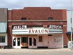 Avalon Theater |
February 4, 1991 (#90002191) |
210 Towner Ave. 47°54′19″N 97°37′25″W |
Larimore | Art Deco style movie theater built in 1938 as a 350 seat theater[7] |
| 2 | Harriet and Thomas Beare House | 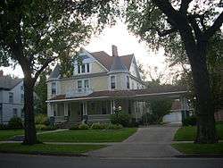 Harriet and Thomas Beare House |
April 20, 1995 (#95000469) |
420 Reeves Dr. 47°55′04″N 97°01′36″W |
Grand Forks | Victorian house built in 1901 for real estate man Thomas Beare, exemplifying the conspicuous consumption of the cities' elite during the Progressive Era and the growth of the Second Dakota Boom.[8] |
| 3 | R.S. Blome Granitoid Pavement in Grand Forks | 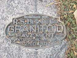 R.S. Blome Granitoid Pavement in Grand Forks |
November 5, 1991 (#91001583) |
Roughly Lewis Boulevard south of Conklin Ave. and the area around the junctions of Walnut St. and 3rd Ave. and Minnesota Ave. and 5th St. 47°55′27″N 97°01′58″W |
Grand Forks | Paved area of a historic road surface, a Portland cement–aggregate combination that was intended to bridge the gap between the needs of Horse-drawn vehicles, which required sure footing, and automobiles, which needed a hard, resilient surface, in the early 1900s.[9] Boundary decreased on August 30, 2010. |
| 4 | B'nai Israel Synagogue and Montefiore Cemetery | 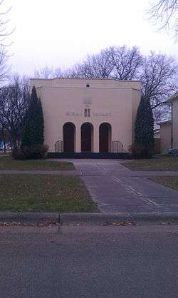 B'nai Israel Synagogue and Montefiore Cemetery |
October 13, 2011 (#11000745) |
601 Cottonwood St. and 1450 N. Columbia Rd. 47°56′02″N 97°04′00″W |
Grand Forks | |
| 5 | Building at 201 S. 3rd St. | 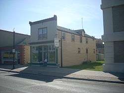 Building at 201 S. 3rd St. |
October 26, 1982 (#82001315) |
201 S. 3rd St. 47°55′23″N 97°01′37″W |
Grand Forks | Built in 1888, "one of three frame storefront buildings in Grand Forks dating from the early period of frame construction along South Third Street, which was the original main thoroughfare in the city between 1870 and the coming of the railroad and the great Dakota Boom in the 1880s. It represents the first period of early boom town building in the city."[10] Relocated to 216 S. 3rd St. after the 1997 Red River flood[11] |
| 6 | Building at 205 DeMers Ave. | October 26, 1982 (#82001316) |
205 DeMers Ave. 47°55′32″N 97°01′46″W |
Grand Forks | Destroyed by the 1997 Red River flood[12] | |
| 7 | Building at 312 Kittson Ave. | 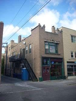 Building at 312 Kittson Ave. |
October 26, 1982 (#82001317) |
312 Kittson Ave. 47°55′27″N 97°01′45″W |
Grand Forks | |
| 8 | Building at 317 S. 3rd St. | October 26, 1982 (#82001318) |
317 S. 3rd St. 47°55′21″N 97°01′30″W |
Grand Forks | Destroyed by the 1997 Red River flood[12] | |
| 9 | Thomas D. Campbell House | 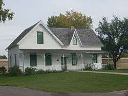 Thomas D. Campbell House |
September 29, 1987 (#87002010) |
2405 Belmont Rd. 47°53′47″N 97°01′38″W |
Grand Forks | Gothic Revival style log and wood frame home built in 1879, now a house museum.[13] |
| 10 | George B. Clifford House | 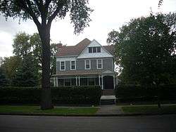 George B. Clifford House |
September 30, 1986 (#86002655) |
406 Reeves Dr. 47°55′06″N 97°01′36″W |
Grand Forks | |
| 11 | Dakota Block | 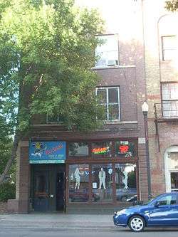 Dakota Block |
October 26, 1982 (#82001320) |
21 S. 4th St. 47°55′26″N 97°01′48″W |
Grand Forks | |
| 12 | Joseph Bell DeRemer House | 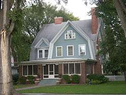 Joseph Bell DeRemer House |
June 9, 1983 (#83001933) |
625 Belmont Rd. 47°54′57″N 97°01′42″W |
Grand Forks | |
| 13 | Dinnie Apartments |  Dinnie Apartments |
June 3, 1994 (#94000555) |
102-108 4th Ave., S. 47°55′07″N 97°01′33″W |
Grand Forks | Part of Downtown Grand Forks MRA. |
| 14 | Downtown Grand Forks Historic District | 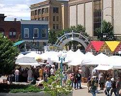 Downtown Grand Forks Historic District |
December 28, 2005 (#05001475) |
Downtown Grand Forks, at the Red River of the North 47°55′35″N 97°01′51″W |
Grand Forks | |
| 15 | Edgar Building | 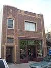 Edgar Building |
April 15, 1983 (#83001934) |
314 Kittson Ave. 47°55′27″N 97°01′46″W |
Grand Forks | |
| 16 | Finks and Gokey Block | 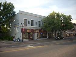 Finks and Gokey Block |
April 20, 1983 (#83001935) |
414-420 DeMers Ave. 47°55′27″N 97°01′55″W |
Grand Forks | |
| 17 | First National Bank | 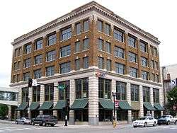 First National Bank |
October 26, 1982 (#82001323) |
322 DeMers Ave. 47°55′29″N 97°01′52″W |
Grand Forks | Damaged by fire during the 1997 Red River flood. Only burned structure to survive.[14] |
| 18 | Ben Franklin Elementary School | July 17, 2020 (#100005260) |
1016 South 20th St. 47°54′43″N 97°03′20″W |
Grand Forks | ||
| 19 | Carlott Funseth Round Barn | October 7, 1986 (#86002752) |
ND 38 47°46′46″N 97°35′56″W |
Kempton | ||
| 20 | Grand Forks City Hall | 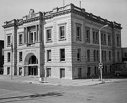 Grand Forks City Hall |
October 26, 1982 (#82001325) |
404 N. 2nd Ave. 47°55′33″N 97°02′03″W |
Grand Forks | |
| 21 | Grand Forks County Courthouse | 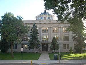 Grand Forks County Courthouse |
November 25, 1980 (#80002913) |
S. 5th St 47°55′22″N 97°01′46″W |
Grand Forks | |
| 22 | Grand Forks County Fairgrounds WPA Structures |  Grand Forks County Fairgrounds WPA Structures |
April 21, 2009 (#08001262) |
2300 Gateway Dr. 47°55′59″N 97°03′34″W |
Grand Forks | |
| 23 | Grand Forks Herald | 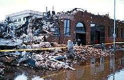 Grand Forks Herald |
November 30, 1982 (#82001326) |
120-124 N. 4th St. 47°55′33″N 97°01′58″W |
Grand Forks | Destroyed by the 1997 Red River flood and subsequent fire.[14] |
| 24 | Grand Forks Mercantile Building 1898 | 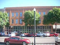 Grand Forks Mercantile Building 1898 |
July 14, 2004 (#04000700) |
112-118 N. 3rd St. 47°55′42″N 97°01′56″W |
Grand Forks | |
| 25 | Grand Forks Mercantile Co. | 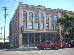 Grand Forks Mercantile Co. |
October 26, 1982 (#82001327) |
124 N. 3rd St. 47°55′36″N 97°01′56″W |
Grand Forks | |
| 26 | Grand Forks Near Southside Historic District |  Grand Forks Near Southside Historic District |
July 28, 2004 (#04000757) |
Roughly bounded by ND 697, the Red River, 13th Ave., and Cottonwood St.; also 1216 Belmont Rd. 47°55′03″N 97°01′37″W |
Grand Forks | Belmont Road address represents a boundary increase |
| 27 | Grand Forks Riverside Neighborhood Historic District |  Grand Forks Riverside Neighborhood Historic District |
November 15, 2007 (#07000181) |
North of U.S. Route 2 (Gateway Dr. and west of the Red River) 47°56′14″N 97°02′32″W |
Grand Forks | |
| 28 | Grand Forks Woolen Mills | 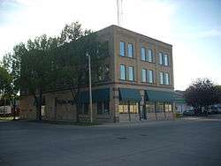 Grand Forks Woolen Mills |
October 26, 1983 (#83001936) |
301 N. 3rd St. 47°55′38″N 97°02′02″W |
Grand Forks | |
| 29 | Great Northern Freight Warehouse and Depot | January 29, 1990 (#89002031) |
899 2nd Ave., N. 47°55′15″N 97°02′15″W |
Grand Forks | ||
| 30 | Hariman Sanatorium | 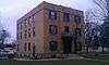 Hariman Sanatorium |
August 28, 2013 (#13000633) |
2002 University Ave. 47°55′21″N 97°03′21″W |
Grand Forks | |
| 31 | Hook and Ladder No. 1 and Hose Co. No. 2 | 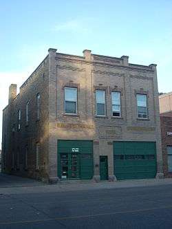 Hook and Ladder No. 1 and Hose Co. No. 2 |
October 26, 1982 (#82001328) |
215 S. 4th St. 47°55′21″N 97°01′38″W |
Grand Forks | |
| 32 | House at 1648 Riverside Drive | September 2, 1994 (#94001074) |
1648 Riverside Dr. 47°56′09″N 97°02′11″W |
Grand Forks | ||
| 33 | Iddings Block | 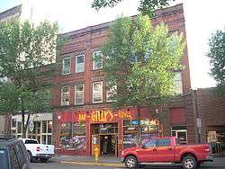 Iddings Block |
October 26, 1982 (#82001329) |
9 N. 3rd St. 47°55′32″N 97°01′52″W |
Grand Forks | |
| 34 | The Kegs Drive-In |  The Kegs Drive-In |
August 24, 2011 (#11000603) |
901 N. 5th St. 47°55′48″N 97°02′39″W |
Grand Forks | |
| 35 | J. Nelson Kelly House | 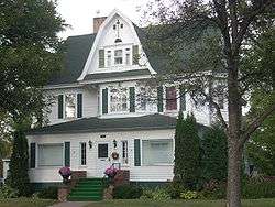 J. Nelson Kelly House |
February 18, 1994 (#94000058) |
521 S. 5th St. 47°55′10″N 97°01′28″W |
Grand Forks | |
| 36 | Larimore City Hall | 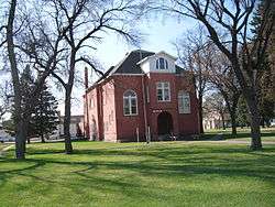 Larimore City Hall |
May 31, 1990 (#90000600) |
Block 64, bounded by Towner, 3rd, Terry, and Main 47°54′23″N 97°37′58″W |
Larimore | |
| 37 | Lewis and Clark Elementary School | 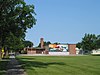 Lewis and Clark Elementary School |
July 17, 2020 (#100005261) |
1100 13th Ave. South 47°54′32″N 97°02′34″W |
Grand Forks | |
| 38 | Martin V. Linwell House | February 28, 1980 (#80002914) |
316 S. Raymond St. 47°43′56″N 97°34′05″W |
Northwood | ||
| 39 | Lyons Garage | 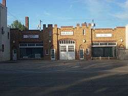 Lyons Garage |
October 26, 1982 (#82001330) |
214-218 N. 4th St. 47°55′35″N 97°02′03″W |
Grand Forks | |
| 40 | Masonic Temple | 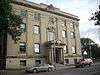 Masonic Temple |
October 26, 1982 (#82001331) |
413-421 Bruce Ave. 47°55′18″N 97°01′43″W |
Grand Forks | |
| 41 | Metropolitan Opera House | 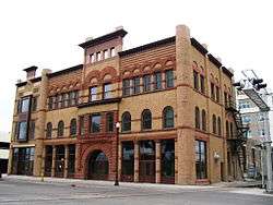 Metropolitan Opera House |
August 27, 1999 (#99001048) |
116 S. 3rd St. 47°55′26″N 97°01′41″W |
Grand Forks | |
| 42 | Midway Bridge | February 27, 1997 (#97000176) |
Unnamed county road across an unnamed creek, approximately 1.5 miles south and 2 miles west of Johnstown 48°07′50″N 97°30′50″W |
Johnstown | ||
| 43 | New Hampshire Apartments | 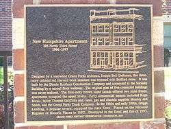 New Hampshire Apartments |
October 26, 1982 (#82001332) |
105 N. 3rd St. 47°55′34″N 97°01′55″W |
Grand Forks | Classically-detailed, Early Commercial building designed by Joseph DeRemer, constructed by Dinnie Brothers in 1904; destroyed by the 1997 Red River flood,[14] A historical marker indicates that the building was destroyed in the 1997 Red River flood and fire. |
| 44 | North Dakota Mill and Elevator | 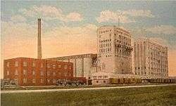 North Dakota Mill and Elevator |
May 11, 1992 (#92000433) |
1823 Mill Rd. 47°56′21″N 97°03′21″W |
Grand Forks | |
| 45 | Northern Pacific Depot and Freight House | 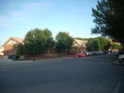 Northern Pacific Depot and Freight House |
October 26, 1982 (#82001333) |
202 N. 3rd St. 47°55′37″N 97°01′58″W |
Grand Forks | |
| 46 | Northwood Bridge | February 27, 1997 (#97000175) |
Unnamed county road across the Goose River, 1.5 miles southwest of Northwood 47°43′03″N 97°36′25″W |
Northwood | Destroyed by overweight load 7/22/2019. | |
| 47 | Odd Fellows Block | 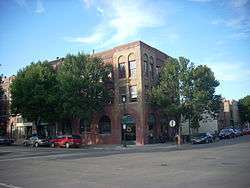 Odd Fellows Block |
October 26, 1982 (#82001334) |
23-25 S. 4th St. 47°55′26″N 97°01′47″W |
Grand Forks | |
| 48 | Ost Valle Bridge | 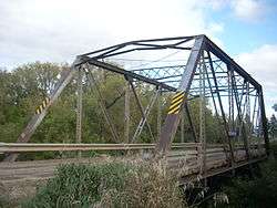 Ost Valle Bridge |
February 27, 1997 (#97000178) |
Unnamed county road across an unnamed tributary of the Red River, approximately 6 miles east and 1 mile north of Thompson 47°47′18″N 96°58′57″W |
Thompson | |
| 49 | Oxford House | 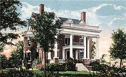 Oxford House |
May 2, 1973 (#73001384) |
University of North Dakota campus 47°55′19″N 97°04′26″W |
Grand Forks | |
| 50 | Roller Office Supply | 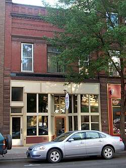 Roller Office Supply |
October 26, 1982 (#82001336) |
7 N. 3rd St. 47°55′31″N 97°01′51″W |
Grand Forks | |
| 51 | St. John's Block Commercial Exchange | 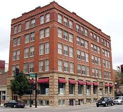 St. John's Block Commercial Exchange |
October 26, 1982 (#82001338) |
2 N. 3rd St. 47°55′32″N 97°01′49″W |
Grand Forks | |
| 52 | St. Michael's Church | 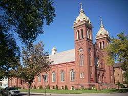 St. Michael's Church |
June 30, 1988 (#88000983) |
520 N. 6th St. 47°55′37″N 97°02′21″W |
Grand Forks | |
| 53 | St. Michael's Hospital and Nurses' Residence | 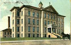 St. Michael's Hospital and Nurses' Residence |
April 20, 1995 (#95000468) |
813 Lewis Boulevard 47°55′57″N 97°02′22″W |
Grand Forks | |
| 54 | St. Michael's Parochial School | July 18, 2016 (#16000457) |
504 N. 5th Ave. 47°55′39″N 97°02′23″W |
Grand Forks | ||
| 55 | Skarsbo Apartments | 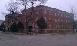 Skarsbo Apartments |
August 27, 2013 (#13000634) |
204 & 210 N. 6th St. 47°55′29″N 97°02′10″W |
Grand Forks | |
| 56 | Sorlie Memorial Bridge | 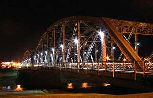 Sorlie Memorial Bridge |
July 19, 1999 (#99000844) |
Eastern end of Demers Ave. 47°55′37″N 97°01′40″W |
Grand Forks | |
| 57 | South Junior High School | 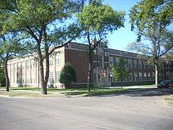 South Junior High School |
March 5, 1999 (#99000274) |
1224 Walnut St. 47°54′33″N 97°01′55″W |
Grand Forks | |
| 58 | Speed Printing | 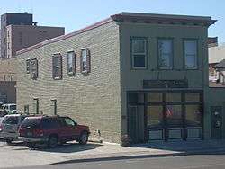 Speed Printing |
October 26, 1982 (#82001337) |
220 S. 3rd St. 47°55′23″N 97°01′35″W |
Grand Forks | |
| 59 | Stratford Building | 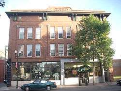 Stratford Building |
October 26, 1982 (#82001339) |
311 DeMers Ave. 47°55′29″N 97°01′50″W |
Grand Forks | |
| 60 | Telephone Co. Building | 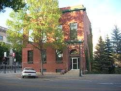 Telephone Co. Building |
October 26, 1982 (#82001340) |
24 N. 4th St. 47°55′31″N 97°01′55″W |
Grand Forks | |
| 61 | U.S. Post Office and Courthouse | 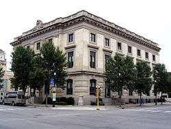 U.S. Post Office and Courthouse |
June 3, 1976 (#76001354) |
102 N. 4th St. 47°55′32″N 97°01′57″W |
Grand Forks | |
| 62 | United Lutheran Church | 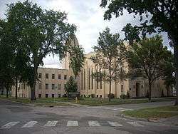 United Lutheran Church |
December 30, 1991 (#91001906) |
324 Chestnut St. 47°55′07″N 97°01′49″W |
Grand Forks | |
| 63 | University of North Dakota Historic District | 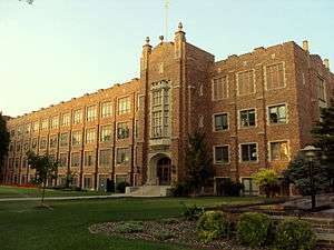 University of North Dakota Historic District |
January 13, 2010 (#08001233) |
University of North Dakota 47°55′21″N 97°04′14″W |
Grand Forks | |
| 64 | Valley Junior High School | July 17, 2020 (#100005262) |
2100 5th Ave. North 47°55′27″N 97°03′23″W |
Grand Forks | ||
| 65 | Viets Hotel | October 26, 1982 (#82001341) |
309-311 3rd St., S. 47°55′22″N 97°01′30″W |
Grand Forks | Damaged by the 1997 Red River flood and destroyed by fire in September 2000[15] | |
| 66 | Viking Elementary School | July 17, 2020 (#100005263) |
809 22nd Ave. South 47°53′55″N 97°02′17″W |
Grand Forks | ||
| 67 | Washington School | 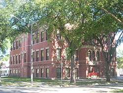 Washington School |
February 24, 1992 (#92000035) |
422 N. 6th St. 47°55′34″N 97°02′18″W |
Grand Forks | |
| 68 | Wells-Denbrook Architects Office Building | November 4, 2014 (#14000900) |
1701 Cherry St. 47°54′13″N 97°02′08″W |
Grand Forks | ||
| 69 | West Elementary School | July 17, 2020 (#100005264) |
615 North 25th St. 47°55′32″N 97°03′46″W |
Grand Forks | ||
| 70 | Dr. Henry Wheeler House | 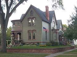 Dr. Henry Wheeler House |
January 16, 1986 (#86000166) |
420 Franklin St. 47°55′13″N 97°01′33″W |
Grand Forks | |
| 71 | Wilder Elementary School | July 17, 2020 (#100005265) |
1009 North 3rd St. 47°55′58″N 97°02′38″W |
Grand Forks | ||
| 72 | WPA Stone Structures in Memorial Park and Calvary Cemetery | 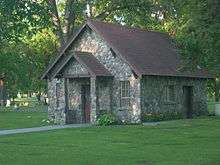 WPA Stone Structures in Memorial Park and Calvary Cemetery |
July 6, 2010 (#10000424) |
Southeast corner from intersection of Gateway Dr. and N Columbia Rd. 47°55′59″N 97°04′00″W |
Grand Forks | |
| 73 | Wright Block |  Wright Block |
October 26, 1982 (#82001342) |
408-412 DeMers Ave. 47°55′28″N 97°01′54″W |
Grand Forks |
Former listings
| [5] | Name on the Register | Image | Date listed | Date removed | Location | City or town | Summary |
|---|---|---|---|---|---|---|---|
| 1 | BPOE Lodge: Golden Block | October 26, 1982[16] (#82001314) | September 23, 2004 | 12 N. 4th St. |
Grand Forks | Early Commercial/vernacular style building that was designed and/or built by Josep Bell DeRemer. Destroyed by the 1997 Red River flood.[17] | |
| 2 | Clifford Annex | October 26, 1982[16] (#82001319) | September 23, 2004 | 407-411 DeMers Ave. |
Grand Forks | Destroyed by the 1997 Red River flood and subsequent fire.[17] | |
| 3 | Dinnie Block | October 26, 1982[16] (#82001321) | September 23, 2004 | 109 N. 3rd Ave. |
Grand Forks | Destroyed by the 1997 Red River flood.[17] | |
| 4 | Electric Construction Co. Building | October 26, 1982[16] (#82001322) | September 23, 2004 | 16 S. 4th St. |
Grand Forks | Destroyed by the 1997 Red River flood.[17] | |
| 5 | Flatiron Building | October 26, 1982[16] (#82001324) | September 23, 2004 | 323 Kittson Ave. |
Grand Forks | Destroyed by the 1997 Red River flood.[17] | |
| 6 | Red River Valley Brick Co. | October 26, 1982[16] (#82001335) | September 23, 2004 | 215 S. 3rd St. |
Grand Forks | Destroyed by the 1997 Red River flood.[17] |
See also
| Wikimedia Commons has media related to National Register of Historic Places in Grand Forks County, North Dakota. |
References
- The latitude and longitude information provided in this table was derived originally from the National Register Information System, which has been found to be fairly accurate for about 99% of listings. Some locations in this table may have been corrected to current GPS standards.
- Norene Roberts & Joe Roberts (November 30, 1981). "National Register of Historic Places: Downtown Grand Forks MRA". National Park Service.
- "Archive info" (PDF). Retrieved 2014-08-19.
- "National Register of Historic Places: Weekly List Actions". National Park Service, United States Department of the Interior. Retrieved on August 14, 2020.
- Numbers represent an ordering by significant words. Various colorings, defined here, differentiate National Historic Landmarks and historic districts from other NRHP buildings, structures, sites or objects.
- The eight-digit number below each date is the number assigned to each location in the National Register Information System database, which can be viewed by clicking the number.
- Dennis McCoy (November 3, 1990). "NRHP Registration: Avalon Theater". National Park Service. and Accompanying nine photos, exterior and interior, from 1990
- Roberts, Norene; Roberts, Joe (1995-04-20). "National Register of Historic Places Registration Form". National Register of Historic Places Registration Form. National Park Service. Retrieved 2009-09-28.
- Morris, Sally; Morris, Clyde; McCrosky, Lauren (August 23, 1991). "R.S. Blome Granitoid Pavement in Grand Forks". National Register of Historic Places Registration Form. National Park Service. Retrieved 2009-09-29.
- C. Kudzia; Norene Roberts; Joe Roberts & Gary Henrickson (July 1981). "North Dakota Cultural Resources Survey: Building at 201 S. 3rd St". National Park Service. and Accompanying three photos from 1981
- "Downtown Grand Forks Historic District Registration, 2005, Section 7 Page 15" (PDF). Retrieved 2014-08-19.
- [eDocket (3/21/2005) http://edocket.access.gpo.gov/2005/05-5447.htm]
- Roberts, Norene A. (1987-09-29). "Thomas D Campbell House". National Register of Historic Places Registration Form. National Park Service. Retrieved 2009-09-30.
- "After Hell and High Water". Draves.com. Retrieved 2014-08-19.
- Johnson, Rona K (June 27, 2002). "Treasures uncovered Archaeologists now digging at the site of the Richardson Store/Hotel Mentone". Grand Forks Herald. Riverwatch Online. Archived from the original on October 2, 2006. Retrieved January 26, 2016.
- "Department of the Interior: National Park Service: National Register of Historic Places; Annual Listing of Historic Properties", 49 FR 4608 (February 7, 1984), at p. 4657.
- "Weekly Announcements October 15, 2004". National Park Service. October 15, 2004.
| Topics | |
|---|---|
| Lists by state |
|
| Lists by insular areas | |
| Lists by associated state | |
| Other areas | |
| Related | |
| |
Municipalities and communities of Grand Forks County, North Dakota, United States | ||
|---|---|---|
| Cities | Map of North Dakota highlighting Grand Forks County | |
| Townships |
| |
| CDP | ||
| Unincorporated communities |
| |
| Ghost town |
| |
| Footnotes | ‡This populated place also has portions in an adjacent county or counties | |