National Register of Historic Places listings in Stutsman County, North Dakota
This is a list of the National Register of Historic Places listings in Stutsman County, North Dakota.
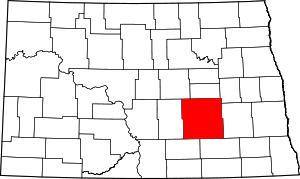
Location of Stutsman County in North Dakota
This is intended to be a complete list of the properties and districts on the National Register of Historic Places in Stutsman County, North Dakota, United States. The locations of National Register properties and districts for which the latitude and longitude coordinates are included below, may be seen in a map.[1]
There are 11 properties and districts listed on the National Register in the county. Another property was once listed but has been removed.
| Adams | Barnes | Benson | Billings | Bottineau | Bowman | Burke | Burleigh | Cass | Cavalier | Dickey | Divide | Dunn | Eddy | Emmons | Foster | Golden Valley | Grand Forks | Grant | Griggs | Hettinger | Kidder | La Moure | Logan | McHenry | McIntosh | McKenzie | McLean | Mercer | Morton | Mountrail | Nelson | Oliver | Pembina | Pierce | Ramsey | Ransom | Renville | Richland | Rolette | Sargent | Sheridan | Sioux | Slope | Stark | Steele | Stutsman | Towner | Traill | Walsh | Ward | Wells | Williams |
- This National Park Service list is complete through NPS recent listings posted August 14, 2020.[2]
Current listings
| [3] | Name on the Register | Image | Date listed[4] | Location | City or town | Description |
|---|---|---|---|---|---|---|
| 1 | Stephen William Brown Stone House | 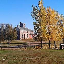 Stephen William Brown Stone House |
February 4, 2004 (#03001545) |
4829 75 R Ave., SE 46°42′58″N 98°52′57″W |
Montpelier | |
| 2 | Alfred E. Dickey Free Library | 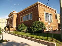 Alfred E. Dickey Free Library |
July 3, 1980 (#80004545) |
105 3rd St., SE. 46°54′24″N 98°42′28″W |
Jamestown | |
| 3 | Elizabeth Apartments | Elizabeth Apartments |
April 21, 1986 (#86000871) |
402 2nd Ave. NW. 46°54′43″N 98°42′35″W |
Jamestown | |
| 4 | Franklin School | 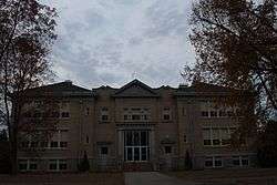 Franklin School |
May 9, 2002 (#02000474) |
308 2nd St. SW. 46°54′28″N 98°42′42″W |
Jamestown | |
| 5 | Grace Episcopal Church | 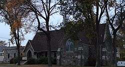 Grace Episcopal Church |
December 3, 1992 (#92001606) |
Northwestern corner of the junction of 2nd Ave. NE. and 4th St. NE. 46°54′41″N 98°42′23″W |
Jamestown | |
| 6 | Jamestown Historic District | September 8, 1989 (#88000987) |
Roughly bounded by 1st St., 4th Ave., SE., 5th St., and 2nd Ave. 46°54′20″N 98°42′23″W |
Jamestown | ||
| 7 | Midland Continental Overpass | February 27, 1997 (#97000194) |
Over an abandoned railroad grade, former U.S. Route 10, approximately 7 miles east of Jamestown 46°56′09″N 98°32′55″W |
Jamestown | Replaced in 2005 | |
| 8 | Seiler Building | 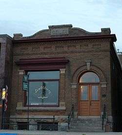 Seiler Building |
January 16, 1986 (#86000080) |
110 1st St., E. 46°54′30″N 98°42′25″W |
Jamestown | |
| 9 | St. James Catholic Church | _interior_1.jpg) St. James Catholic Church |
October 22, 1982 (#82001346) |
622 1st Ave., S. 46°54′10″N 98°42′32″W |
Jamestown | |
| 10 | Stutsman County Courthouse and Sheriff's Residence/Jail | 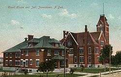 Stutsman County Courthouse and Sheriff's Residence/Jail |
September 8, 1976 (#76001356) |
504 3rd Ave., SE. 46°54′13″N 98°42′20″W |
Jamestown | |
| 11 | Voorhees Chapel | 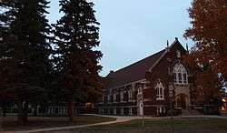 Voorhees Chapel |
July 22, 1977 (#77001030) |
Jamestown College campus 46°54′52″N 98°41′57″W |
Jamestown |
Former listing
| [3] | Name on the Register | Image | Date listed | Date removed | Location | City or town | Summary |
|---|---|---|---|---|---|---|---|
| 1 | Cecil Baker Round Barn | August 21, 1986 (#86002759) | March 28, 2011 | ND 38 47°15′13″N 98°52′47″W |
Kensal | Demolished 2010 [5] |
gollark: You can use codegen to generate code for repetitive tasks of some sort if they don't need to generalize much or go outside your project, but it's much better to just... not have to do those repetitive tasks, or have the compiler/macros handle them.
gollark: Also, you end up with a mess of fragile infrastructure which operates on stringy representations of the code.
gollark: I can either:- use `interface{}` - lose type safety and performance- codegen a different `Tree` type for every use of it - now I can't really put it in its own library and it's generally inelegant and unpleasant
gollark: Consider what happens if I want to implement a generic `Tree` type.
gollark: For one thing, it doesn't really work in many cases.
See also
| Wikimedia Commons has media related to National Register of Historic Places in Stutsman County, North Dakota. |
References
- The latitude and longitude information provided in this table was derived originally from the National Register Information System, which has been found to be fairly accurate for about 99% of listings. Some locations in this table may have been corrected to current GPS standards.
- "National Register of Historic Places: Weekly List Actions". National Park Service, United States Department of the Interior. Retrieved on August 14, 2020.
- Numbers represent an ordering by significant words. Various colorings, defined here, differentiate National Historic Landmarks and historic districts from other NRHP buildings, structures, sites or objects.
- The eight-digit number below each date is the number assigned to each location in the National Register Information System database, which can be viewed by clicking the number.
- State Historical Society of North Dakota
| Topics | |
|---|---|
| Lists by state |
|
| Lists by insular areas | |
| Lists by associated state | |
| Other areas | |
| Related | |
| |
Municipalities and communities of Stutsman County, North Dakota, United States | ||
|---|---|---|
| Cities | Map of North Dakota highlighting Stutsman County | |
| Townships |
| |
| CDPs | ||
| Unorganized territories |
| |
| Unincorporated communities | ||
This article is issued from Wikipedia. The text is licensed under Creative Commons - Attribution - Sharealike. Additional terms may apply for the media files.