National Register of Historic Places listings in Burleigh County, North Dakota
This is a list of the National Register of Historic Places listings in Burleigh County, North Dakota.
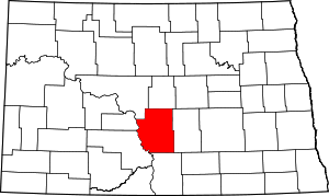
Location of Burleigh County in North Dakota
This is intended to be a complete list of the properties and districts on the National Register of Historic Places in Burleigh County, North Dakota, United States. The locations of National Register properties and districts for which the latitude and longitude coordinates are included below, may be seen in a map.[1]
There are 25 properties and districts listed on the National Register in the county, including 1 National Historic Landmark. Another 5 properties were once listed but have been removed.
| Adams | Barnes | Benson | Billings | Bottineau | Bowman | Burke | Burleigh | Cass | Cavalier | Dickey | Divide | Dunn | Eddy | Emmons | Foster | Golden Valley | Grand Forks | Grant | Griggs | Hettinger | Kidder | La Moure | Logan | McHenry | McIntosh | McKenzie | McLean | Mercer | Morton | Mountrail | Nelson | Oliver | Pembina | Pierce | Ramsey | Ransom | Renville | Richland | Rolette | Sargent | Sheridan | Sioux | Slope | Stark | Steele | Stutsman | Towner | Traill | Walsh | Ward | Wells | Williams |
- This National Park Service list is complete through NPS recent listings posted August 14, 2020.[2]
Current listings
| [3] | Name on the Register | Image | Date listed[4] | Location | City or town | Description |
|---|---|---|---|---|---|---|
| 1 | Bismarck Cathedral Area Historic District | 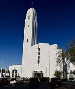 Bismarck Cathedral Area Historic District |
May 8, 1980 (#80002908) |
Roughly bounded by Hannifan and N. 1st Sts. and Aves. C and A, W.; also roughly along N. 1st, N. Mandan, N. Washington, and N. Raymond Sts., and Aves. C, D, and E, W.; also 104, 106, 112, 115, 116, and 120 E. Ave B and 523 N. 1st St. (but removing 316 and 320 W. Ave. A and 510 N. Washington St.) 46°48′37″N 100°47′36″W |
Bismarck | Second and third sets of addresses represent boundary increases |
| 2 | Bismarck Civic Auditorium |  Bismarck Civic Auditorium |
June 7, 1976 (#76001351) |
201 N. 6th St. 46°48′24″N 100°46′56″W |
Bismarck | |
| 3 | Bismarck Tribune Building | 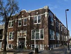 Bismarck Tribune Building |
October 22, 1982 (#82001309) |
22 N. 4th St. 46°48′26″N 100°47′10″W |
Bismarck | |
| 4 | Dr. Albert M. and Evelyn M. Brandt House | 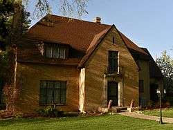 Dr. Albert M. and Evelyn M. Brandt House |
August 16, 2000 (#00000992) |
323 E. Ave. B 46°48′01″N 100°47′09″W |
Bismarck | |
| 5 | Burleigh County Courthouse | 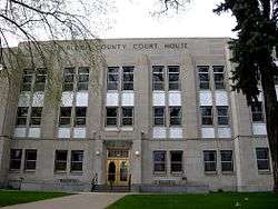 Burleigh County Courthouse |
November 14, 1985 (#85002980) |
E. Thayer Ave. 46°48′28″N 100°47′01″W |
Bismarck | |
| 6 | Camp Hancock Site | 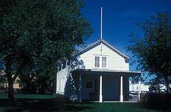 Camp Hancock Site |
February 23, 1972 (#72001004) |
101 Main Ave. 46°48′19″N 100°47′30″W |
Bismarck | |
| 7 | Chief Looking's Village site (32BL3) |  Chief Looking's Village site (32BL3) |
November 21, 1978 (#78001990) |
Eastern edge of Pioneer Park 46°49′49″N 100°49′46″W |
Bismarck | |
| 8 | Depression Era Work Relief Construction Features at Double Ditch Indian Village Site State Historic Site | 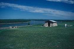 Depression Era Work Relief Construction Features at Double Ditch Indian Village Site State Historic Site |
November 5, 2014 (#14000896) |
ND 1804 46°56′11″N 100°54′04″W |
Bismarck vicinity | Federal Relief Construction in North Dakota, 1931-1943, MPS |
| 9 | Depression Era Work Relief Construction Features at Menoken State Historic Site |  Depression Era Work Relief Construction Features at Menoken State Historic Site |
December 7, 2010 (#10000998) |
171st St. and 32nd Ave. NE; 1.7 miles north of Menoken 46°50′29″N 100°31′07″W |
Bismarck | Federal Relief Construction in North Dakota, 1931-1943, MPS |
| 10 | Double Ditch Earth Lodge Village Site (32BL8) | 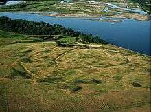 Double Ditch Earth Lodge Village Site (32BL8) |
January 29, 1979 (#79001769) |
Left bank of the Missouri River above Bismarck[5] 46°56′12″N 100°54′04″W |
Bismarck | |
| 11 | Downtown Bismarck Historic District |  Downtown Bismarck Historic District |
October 28, 2001 (#01001188) |
Roughly bounded by Broadway and Thayer Aves., 5th St., Burlington and Santa Fe railroad line, and Washington and 2nd Sts. 46°48′12″N 100°47′23″W |
Bismarck | |
| 12 | Florence Lake School No. 3 | November 1, 2011 (#11000786) |
10 miles north of Wing off ND 14 47°16′20″N 100°17′01″W |
Wing | ||
| 13 | Former North Dakota Executive Mansion | 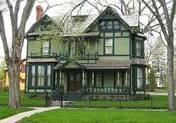 Former North Dakota Executive Mansion |
April 16, 1975 (#75001301) |
320 Ave. B, E. 46°48′40″N 100°47′10″W |
Bismarck | |
| 14 | Fred and Gladys Grady House | 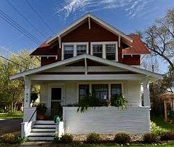 Fred and Gladys Grady House |
July 21, 2006 (#06000636) |
414 E. Ave. F 46°48′56″N 100°47′05″W |
Bismarck | |
| 15 | Oliver and Gertrude Lundquist House | 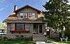 Oliver and Gertrude Lundquist House |
July 21, 2006 (#06000637) |
622 W. Thayer St. 46°48′29″N 100°48′00″W |
Bismarck | |
| 16 | Menoken Indian Village Site | 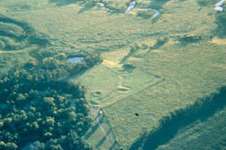 Menoken Indian Village Site |
October 15, 1966 (#66000599) |
171 St. at 32nd Ave., NE.[6] 46°50′28″N 100°31′06″W |
Menoken | |
| 17 | Northern Pacific Railway Depot | 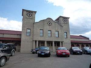 Northern Pacific Railway Depot |
September 19, 1977 (#77001022) |
407 E. Main Ave. 46°48′18″N 100°47′07″W |
Bismarck | |
| 18 | Our Lady of the Annunciation Chapel at Annunciation Priory | Our Lady of the Annunciation Chapel at Annunciation Priory |
June 16, 2020 (#100005177) |
7500 University Dr. (University of Mary) 46°43′18″N 100°45′14″W |
Bismarck | |
| 19 | Patterson Hotel |  Patterson Hotel |
December 8, 1976 (#76001352) |
422 E. Main Ave. 46°48′21″N 100°47′05″W |
Bismarck | |
| 20 | E. G. Patterson Building | 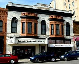 E. G. Patterson Building |
October 22, 1982 (#82001310) |
412-414 Main St. 46°48′20″N 100°47′05″W |
Bismarck | |
| 21 | Soo Hotel | 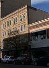 Soo Hotel |
May 9, 1983 (#83001927) |
112-114 5th St., N. 46°48′21″N 100°47′05″W |
Bismarck | |
| 22 | Towne-Williams House | 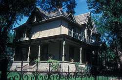 Towne-Williams House |
April 14, 1975 (#75001302) |
722 7th St., N. 46°48′45″N 100°46′53″W |
Bismarck | |
| 23 | U.S. Post Office and Courthouse | 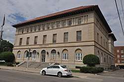 U.S. Post Office and Courthouse |
June 23, 1976 (#76001353) |
304 E. Broadway 46°48′25″N 100°47′13″W |
Bismarck | |
| 24 | Van Horn Hotel |  Van Horn Hotel |
May 10, 1984 (#84002759) |
114 N. 3rd St. 46°48′22″N 100°47′16″W |
Bismarck | |
| 25 | Webb Brothers Block | 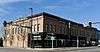 Webb Brothers Block |
October 13, 1983 (#83004060) |
317 E. Main Ave. 46°48′19″N 100°47′11″W |
Bismarck |
Former listings
| [3] | Name on the Register | Image | Date listed | Date removed | Location | City or town | Summary |
|---|---|---|---|---|---|---|---|
| 1 | Bismarck Public Library | December 7, 1977 (#77001020) | Unknown | 519 E. Thayer Ave. |
Bismarck | ||
| 2 | Fire Hall | February 14, 1978 (#78001989) | Unknown | 517 E. Thayer Ave. |
Bismarck | ||
| 3 | James W. Foley House | September 13, 1977 (#77001021) | January 31, 1994 | 522 6th St. |
Bismarck | ||
| 4 | Liberty Memorial Bridge | .jpg) Liberty Memorial Bridge |
March 11, 1997 (#97000172) | March 25, 2009 | Interstate 94 business loop, across the Missouri River 46°48′28″N 100°49′21″W |
Bismarck | Demolished in October 2008. |
| 5 | Yegen House and Pioneer Grocery | October 5, 1977 (#77001023) | February 1, 2011 | 808-810 E. Main Ave. 46°48′20″N 100°46′44″W |
Bismarck |
gollark: Binary but 1s are Rust and 0s are Haskell.
gollark: You can do it *seriously* in one too - Subtract And Branch If Not Positive.
gollark: Easily. My language manages it with *one*.
gollark: Given how little syntax haskell has this *might actually be possible*, except function names.
gollark: Given that haskell is quite case-sensitive I think this is actually unambiguous.
See also
| Wikimedia Commons has media related to National Register of Historic Places in Burleigh County, North Dakota. |
References
- The latitude and longitude information provided in this table was derived originally from the National Register Information System, which has been found to be fairly accurate for about 99% of listings. Some locations in this table may have been corrected to current GPS standards.
- "National Register of Historic Places: Weekly List Actions". National Park Service, United States Department of the Interior. Retrieved on August 14, 2020.
- Numbers represent an ordering by significant words. Various colorings, defined here, differentiate National Historic Landmarks and historic districts from other NRHP buildings, structures, sites or objects.
- The eight-digit number below each date is the number assigned to each location in the National Register Information System database, which can be viewed by clicking the number.
- Stewart, Frank H. "Mandan and Hidatsa Villages in the Eighteenth and Nineteenth Centuries". Plains Anthropologist 19.66 (1974): 287-302: 291.
- This location is derived from this Archived 2005-03-22 at the Wayback Machine National Park service website; the NRIS lists it as "Address Restricted"
| Topics | |
|---|---|
| Lists by state |
|
| Lists by insular areas | |
| Lists by associated state | |
| Other areas | |
| Related | |
| |
Municipalities and communities of Burleigh County, North Dakota, United States | ||
|---|---|---|
| Cities | Map of North Dakota highlighting Burleigh County | |
| Townships |
| |
| CDPs | ||
| Unorganized territories |
| |
| Unincorporated communities | ||
| Ghost town | ||
| Footnotes | ‡This populated place also has portions in an adjacent county or counties | |
This article is issued from Wikipedia. The text is licensed under Creative Commons - Attribution - Sharealike. Additional terms may apply for the media files.